NWS Birmingham, Alabama
Weather Forecast Office
Radar Images 2238Z
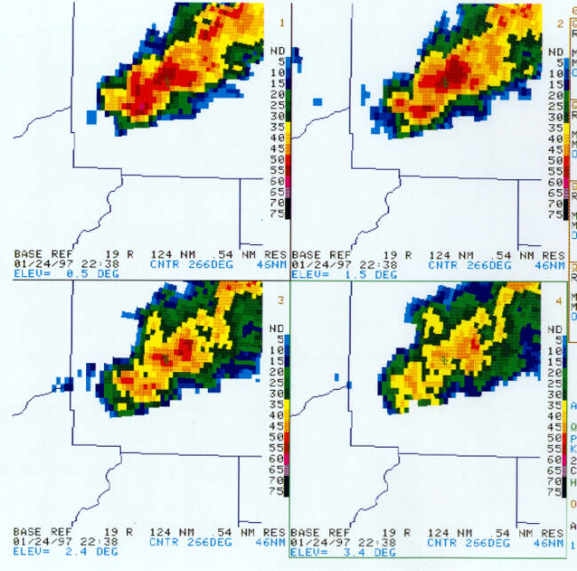 |
| The 2238Z REF data showed the storm was weighted in the lowest levels, i.e., the highest reflectivities were at 0.5 and 1.5 deg elevations. 0.5 deg = 5 kft; 1.5 deg = 10 kft; 2.4 deg = 14.1 kft; and 3.4 deg = 19.1 kft. The echo top at this time was less than 35 kft. |
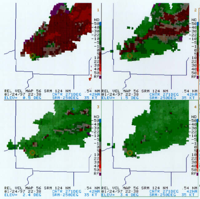 |
| Interestingly, a mesocyclone was detected by the meso algorithm at the end of the 2238Z volume scan. Vr = 26 kts at 0.5 deg; 26 kts at 1.5 deg; 22 kts at 2.4 deg; 19 kts at 3.4 deg; and 21 kts at 4.3 deg. It was only a minimal mesocyclone from an operator's viewpoint (as determined by the chart under the glass at each PUP workstation). |
Current Hazards
National Outlooks
Tropical
Local Storm Reports
Public Information Statement
Graphical Hazardous Weather Outlook
Current Conditions
Regional Weather Roundup
Rivers and Lakes
Drought Monitor
Forecasts
Graphical Forecasts
Forecast Discussion
Air Quality
Fire Weather
Aviation Weather
Climate and Past Weather
Past Events
Storm Data
Tornado Database
Daily Rainfall Plots
Tropical Cyclone Reports
Monthly Climate
Annual Climate
Warnings and Other Products
Tornado Warnings
Severe Thunderstorm Warnings
Flash Flood Warnings
Winter Weather Warnings
Special Weather Statements
Non-Precipitation Warnings
Flood/River Flood Warnings
Productos en Español
Conciencia y Preparación
Previsión de 7 Días
Weather Safety
NOAA Weather Radio
Severe Weather Preparedness
Severe Safety Rules
Tornado Safety Rules
Severe Safety w/ ASL
Awareness Weeks
Severe Weather
Hurricane Preparedness
Summer Safety Campaign
Winter Weather
US Dept of Commerce
National Oceanic and Atmospheric Administration
National Weather Service
NWS Birmingham, Alabama
465 Weathervane Road
Calera, AL 35040
205-664-3010
Comments? Questions? Please Contact Us.

