NWS Birmingham, Alabama
Weather Forecast Office
4-Panel Radar Images
|
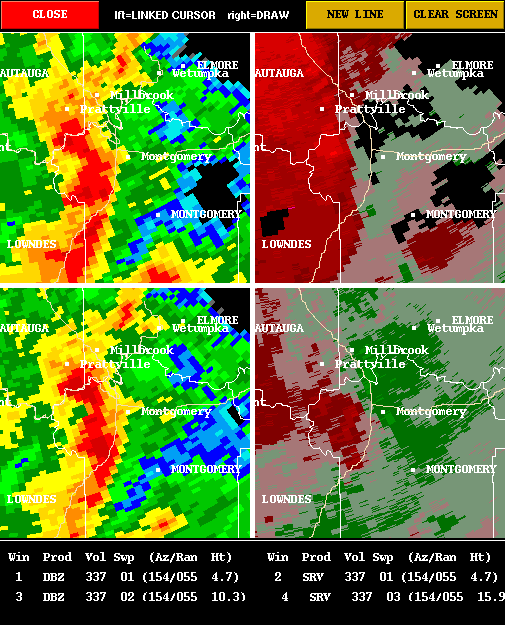
Radar images from the Shelby County Airport WSR-88D. Radar site is north, or top of images. The warm colors, reds to purple, show movement away from the radar, while cool colors, green to light green, shows movement towards the radar. The images are from 9:15 AM CST (1515 UTC) to 9:36 PM CST (1536 UTC). Top left image is 0.5 degree reflectivity and just below is 1.5 degree reflectivity. Top right storm relative velocity (SRM) image is at 0.5 degrees, and the image below is at 1.5 degrees. The damage caused by the tornado places it in the weak category as an F0. The tornado path was 2.3 miles long and about 100 yards wide. The initial touchdown occurred at 9:22 AM and ended at 9:25 AM. Note the weak rotation associated with the thunderstorm moving just north of Montgomery. |
 |
 |
|
|
|
|
|
|
Current Hazards
National Outlooks
Tropical
Local Storm Reports
Public Information Statement
Graphical Hazardous Weather Outlook
Current Conditions
Regional Weather Roundup
Rivers and Lakes
Drought Monitor
Forecasts
Aviation Weather
Graphical Forecasts
Forecast Discussion
Air Quality
Fire Weather
Climate and Past Weather
Past Events
Storm Data
Tornado Database
Daily Rainfall Plots
Tropical Cyclone Reports
Monthly Climate
Annual Climate
Warnings and Other Products
Tornado Warnings
Severe Thunderstorm Warnings
Flash Flood Warnings
Winter Weather Warnings
Special Weather Statements
Non-Precipitation Warnings
Flood/River Flood Warnings
Productos en Español
Conciencia y Preparación
Previsión de 7 Días
Weather Safety
NOAA Weather Radio
Severe Weather Preparedness
Severe Safety Rules
Tornado Safety Rules
Severe Safety w/ ASL
Awareness Weeks
Severe Weather
Hurricane Preparedness
Summer Safety Campaign
Winter Weather
US Dept of Commerce
National Oceanic and Atmospheric Administration
National Weather Service
NWS Birmingham, Alabama
465 Weathervane Road
Calera, AL 35040
205-664-3010
Comments? Questions? Please Contact Us.


