NWS Birmingham, Alabama
Weather Forecast Office
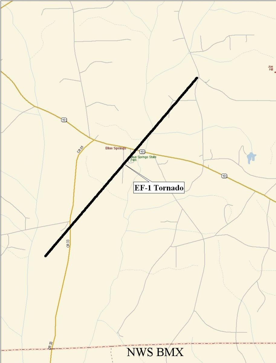
Blue Springs Tornado - January 11, 2008
|
Rating:
(Click for EF Scale) |
EF-1
|
|
Estimated Maximum Wind:
|
95 mph
|
|
Injuries/Fatalities:
|
None
|
|
Damage Path Length:
|
3.48 miles
|
|
Maximum Path Width:
|
150 yards
|
|
Approximate Start Point:
|
31.64/-85.53 at 204 AM
|
|
Approximate End Point:
|
31.68/-85.49 at 210 AM
|
A National Weather Service Damage Assessment Team has surveyed storm damage in southern Barbour County and has determined that the damage was the result of a tornado. The tornado has been rated an EF-1 on the Enhanced Fujita Scale with estimated maximum winds around 95 mph. The tornado damage path was 3.48 miles long and was 150 yards wide at its widest point.
The tornado touched down just southwest of the intersection of CR-33 and CR-72, where it damaged the roof of a mobile home, and tore off a covered deck and a portion of the attached roof of another home. Several large trees were also uprooted in this area. The tornado then tracked northeastward near Blue Springs State Park, with limited tree damage. Near the intersection of CR-70 and CR-41, a pecan tree was partially snapped and twisted, and another
home sustained significant roof damage. Tornado debris punctured the roof of another home across the street. A total of 4 homes and one mobile home was damaged.
|
|
|||||||||
Current Hazards
National Outlooks
Tropical
Local Storm Reports
Public Information Statement
Graphical Hazardous Weather Outlook
Current Conditions
Regional Weather Roundup
Rivers and Lakes
Drought Monitor
Forecasts
Graphical Forecasts
Forecast Discussion
Air Quality
Fire Weather
Aviation Weather
Climate and Past Weather
Past Events
Storm Data
Tornado Database
Daily Rainfall Plots
Tropical Cyclone Reports
Monthly Climate
Annual Climate
Warnings and Other Products
Tornado Warnings
Severe Thunderstorm Warnings
Flash Flood Warnings
Winter Weather Warnings
Special Weather Statements
Non-Precipitation Warnings
Flood/River Flood Warnings
Productos en Español
Conciencia y Preparación
Previsión de 7 Días
Weather Safety
NOAA Weather Radio
Severe Weather Preparedness
Severe Safety Rules
Tornado Safety Rules
Severe Safety w/ ASL
Awareness Weeks
Severe Weather
Hurricane Preparedness
Summer Safety Campaign
Winter Weather
US Dept of Commerce
National Oceanic and Atmospheric Administration
National Weather Service
NWS Birmingham, Alabama
465 Weathervane Road
Calera, AL 35040
205-664-3010
Comments? Questions? Please Contact Us.