Barbour and Tallapoosa Tornadoes - January 7, 2007
Barbour County
National Weather Service meteorologists surveyed storm damage in Barbour County. The damage was the result of a tornado.
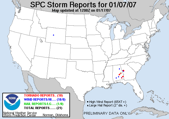
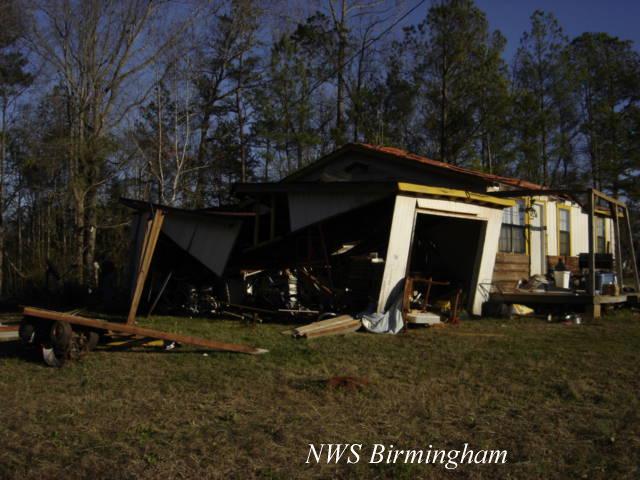
At approximately 829 PM CST...a tornado touched down in far southeastern Barbour County at the White Oak Shores Community. This location is nine miles south of Eufaula along Walter F. George Lake. Several hundred trees were snapped off or uprooted along the path. Numerous mobile homes were damaged and some were totally destroyed at White Oak Shores. The tornado tracked northeastward across White Oak Creek Park and into the far southern part of the Woodlawn Subdivision. The tornado track ended in the Chattahoochee River around 834 PM CST. The tornado damage path was 2.69 miles in length and 200 yards wide at its widest point. Maximum winds were estimated at 100 to 105 mph. The tornado has been rated an F1 on the Fujita Damage Intensity Scale.
A broken line of showers moved across Barbour County out ahead of a cold front. At times, the showers exhibited rotation aloft. Lightning activity was absent and was not typical of a tornadic situation. However, the shower did produce a brief tornado.
A Tornado Watch was in effect for Barbour from 3 PM CST until 10 PM CST.
|
|
||||||||||||||||||||||
Tallapoosa County
National Weather Service meteorologists surveyed storm damage in southern Tallapoosa County. The damage was the result of a tornado.
At approximately 410 PM CST...A tornado touched down south of the Walnut Hill Community...near the intersection of Prospect Road and State Highway 49. The tornado damaged a few homes and destroyed a mobile home on Butterfly Lane. The tornado tracked northeastward and damaged another home on Sandy Drive before lifting around 412 PM CST. Overall...at least three homes sustained damage, one trailer was totally destroyed and about 40 trees were snapped off. The tornado damage path was about one mile long and 50 yards wide at its widest point. Maximum winds were estimated at 85 to 90 mph. The tornado has been rated an F1 on the Fujita Damage Intensity Scale.
A supercell thunderstorm developed out ahead of a cold front and was isolated from other showers in the area. The supercell tracked from near Montgomery Alabama to near Atlanta Georgia. This storm produced the brief tornado anf golf ball size hail in Tallapoosa County and also produced additional damage in Georgia.
A Tornado Watch was in effect for Tallapoosa County from 3 PM CST until 10 PM CST. A Tornado Warning was in effect for Tallapoosa County from 352 PM CST until 415 PM CST. A Tornado Watch was in effect from 1230 PM CST until 8 PM CST.
|
|
||||||||||||||||||||
Preliminary Local Storm Report...Click Here