National Weather Service United States Department of Commerce


Tornadoes of March 30, 2022

Overview
 

A long-duration severe weather event occurred from the late morning hours of Tuesday, January 3rd to the early
morning hours of Wednesday, January 4th. Several rounds of rain and thunderstorms impacted Central Alabama, producing tornadoes, damaging straight-line winds, quarter size hail, and flooding.


View Larger Map

 
Surveys
 

**The data below are considered PRELIMINARY.**

 
Location/Clickable Detailed Summary Link
Damage Rating/Estimated Maximum Wind Speeds
Injuries/Fatalities
Damage Path Length/Width
Starting Point/Time
Ending Point/Time
Old Spring Hill Tornado
(Marengo/Hale Counties)
EF-1
90 mph
None 8.86 miles
275 yards
2 SSW Old Spring Hill
32.4151/-87.7827
11:21 am CST on Jan 3rd
2 ENE Gallion
33.5108/-87.6826
11:33 am CST on Jan 3rd
County Road 29 Tornado
(Perry County)
EF-1
95 mph

 
None 0.15 miles
100 yards
3 E Folsom
32.6835/-87.3491
12:10 pm CST on Jan 3rd
3 E Folsom
32.6848/-87.3469
12:10 pm CST on Jan 3rd
Liberty Road Tornado
(Bibb County)
EF-0
70 mph
None 2.82 miles
100 yards
4 NNW Oakmulgee
32.8493/-87.0548
12:41 pm CST on Jan 3rd
1 WSW Talladega National Forest
32.8737/-87.0158
12:45 pm CST on Jan 3rd
County Road 40 Tornado
(Autauga County)
EF-0
75 mph
None 3.18 miles
60 yards
4 NNW Booth
32.5609/-86.5972
1:18 pm CST on Jan 3rd
3 S Oak Grove
32.5841/-86.5506
1:26 pm CST on Jan 3rd
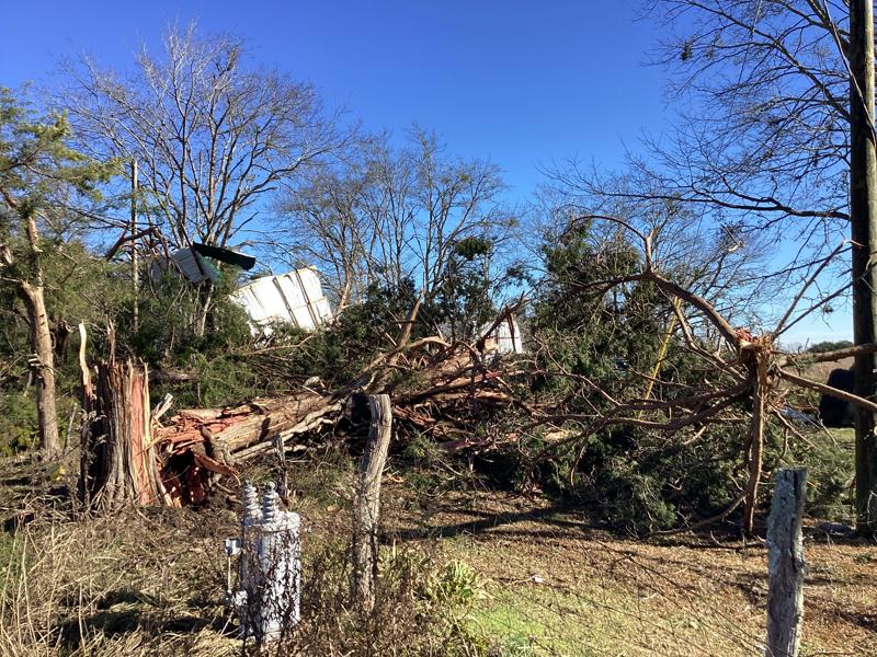
Lay Lake Tornado
(Chilton and Coosa Counties)
EF-1
90 mph
None 2.51 miles
250 yards
2 NNW Lay Lake Dam
32.9880/-86.5264
1:39 pm CST on Jan 3rd
3 NNE Lay Lake Dam
33.0059/-86.4899
1:43 pm CST on Jan 3rd
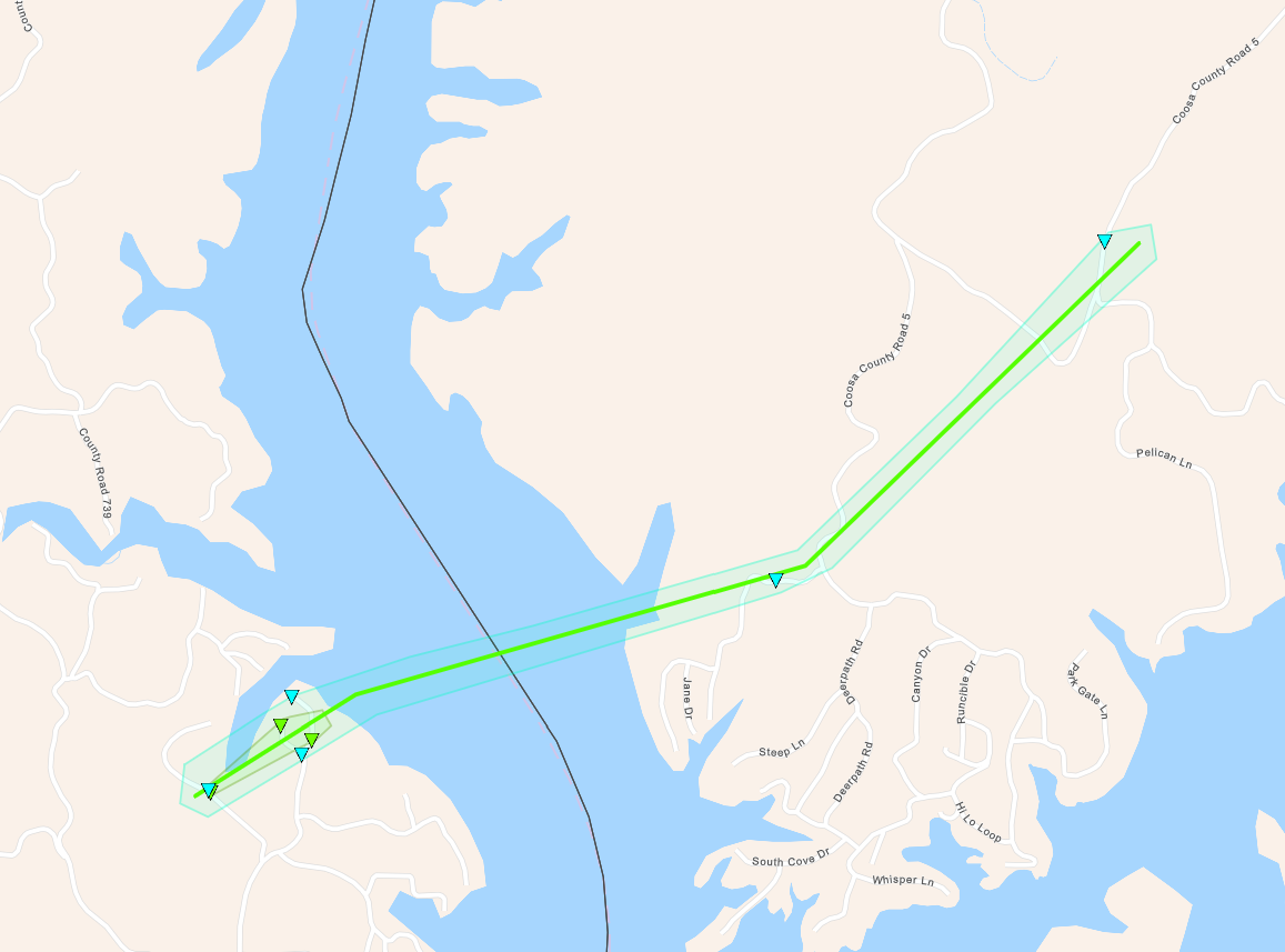
Jordan Lake Tornado
(Elmore County)
EF-2
120 mph
None 9.06 miles
800 yards
1 NW Deatsville
32.6239/-86.4098
1:42 pm CST on Jan 3rd
1 WNW Ten Cedar Estates
32.6747/-86.2678
1:59 pm CST on Jan 3rd
Horne Mountain Tornado
(Clay County)
EF-0
85 mph
None 6.41 miles
300 yards
3 NNW Roselle
33.2350/-86.0693
2:31 pm CST on Jan 3rd
4 SSE Chandler Springs
33.2769/-85.9707
2:45 pm CST on Jan 3rd
Fuller Crossroad Tornado
(Randolph County)
EF-0
80 mph
None 1.11 miles
150 yards
3 NW Ofelia
33.3464/-85.6469
3:17 pm CST on Jan 3rd
3 NNW Ofelia
33.3542/-85.6304
3:19 pm CST on Jan 3rd
Clackville Tornado
(Chambers County)
EF-0
75 mph
None 4.40 miles
500 yards
2 SW Mount Olive
33.0648/-85.4433
3:27 pm CST on Jan 3rd
2 SSW Roanoke Municipal Airport
33.1054/-85.3852
3:37 pm CST on Jan 3rd
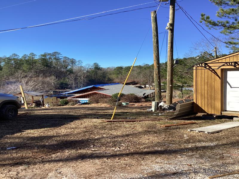
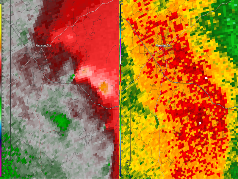
Dadeville Road Tornado
(Tallapoosa County)
EF-1
90 mph
None 3.77 miles
50 yards
2 N Wind Creek State Park
32.8837/-85.9362
2:59 am CST on Jan 4th
3 E Alexander City
32.9159/-85.8840
3:04 am CST on Jan 4th
Halcyon Tornado
(Montgomery County)
EF-1
110 mph

1 injury
0 fatalities

1.87 miles
130 yards
2 SW Auburn University in Montgomery
32.3467/-86.1964
3:00 am CST on Jan 4th
1 SSE Auburn University in Montgomery
32.3520/-86.1653
3:05 am CST on Jan 4th
Deer Run Tornado
(Macon County)
EF-0
70 mph
None 0.67 miles
75 yards
1 SE Shorter
32.3840/-85.9258
3:23 am CST on Jan 4th
1 ESE Shorter
32.3907/-85.9175
3:25 am CST on Jan 4th
Society Hill Tornado
(Macon County)
EF-0
75 mph
None 1.11 miles
100 yards
Society Hill
32.4249/-85.4533
4:07 am CST on Jan 4th
1 ENE Society Hill
32.4297/-85.4351
4:09 am CST on Jan 4th
 
Old Spring Hill EF-1
 

Old Spring Hill to Gallion EF-1 Tornado (Marengo & Hale Counties)
  January 3, 2023


Event Summary

EF-1
Estimated Maximum Wind:
90 mph
Injuries/Fatalities:
None
Damage Path Length:
8.86 miles
Maximum Path Width:
275 yards
Approximate Start Point/Time:
2 SSW Old Spring Hill
32.4151/-87.7827
at 11:21 am CST
Approximate End Point/Time:
2 ENE Gallion
32.5108/-87.6826
at 11:33 am CST


NWS meteorologists confirmed a tornado track extending from Old Spring Hill in northern Marengo County to Gallion in southern Hale County. The tornado began along Highway 43 near Old Spring Hill where a cluster of trees were uprooted and a couple snapped. The tornado continued northeastward with an area of maximum damage along Highway 54 where numerous cedar trees were uprooted and snapped. Metal roofing panels were also lofted into trees and downwind. It is this area of damage that pushed the tornado into EF-1 strength. Minimal vegetative damage continued to Highway 80 in Gallion where the tornado dissipated. The tornado vortex was quite narrow along most of its path, but much wider along Highway 54. 

Tornado Track Map


Radar Image
Reflectivity (left) and velocity (right).
Images are from KBMX at 11:24 am CST.


Damage Photo
 Cedar trees broken and metal roofing sheets lofted.
 
County Road 29 EF-1
 

County Road 29 EF-1 Tornado (Perry County)
  January 3, 2023


Event Summary

EF-1
Estimated Maximum Wind:
95 mph
Injuries/Fatalities:
None
Damage Path Length:
0.15 miles
Maximum Path Width:
100 yards
Approximate Start Point/Time:
3 E Folsom
32.6835/-87.3491
at 12:10 pm CST
Approximate End Point/Time:
3 E Folsom
32.6848/-87.3469
at 12:10 pm CST


NWS meteorologists confirmed a short-lived EF-1 tornado path along County Road 29, northwest of Marion in Perry County. The tornado vortex quickly developed and dissipated along one of the only residential areas along this stretch of road. A manufactured home was shifted off its block foundation with a large section of roofing material removed from the back side of the home. Two homeowners were present during the time of impact and were tossed onto the floor while having a meal. Thankfully, they were uninjured. Metal panels were lofted into trees either side of the highway. Some trees were also uprooted and snapped in the area. It is possible some additional light timber damage may have continued beyond the end of the estimated path, but the area is inaccessible and radar shows the area of rotation quickly weakening.  

Tornado Track Map


Radar Image
Reflectivity (left) and velocity (right).
Images are from KBMX at 12:09 pm CST.
 
Damage Photo
 Manufactured home shifted off its block foundation. Portions of the rear roof were also removed.
 
Liberty Road EF-0
 

Liberty Road EF-0 Tornado (Bibb County)
  January 3, 2023


Event Summary

EF-0
Estimated Maximum Wind:
70 mph
Injuries/Fatalities:
None
Damage Path Length:
2.82 miles
Maximum Path Width:
100 yards
Approximate Start Point/Time:
4 NNW Oakmulgee
32.8493/-87.0548
at 12:41 pm CST
Approximate End Point/Time:
1 WSW Talladega National Forest
32.8737/-87.0158
at 12:45 pm CST


The tornado touched down southwest of Liberty Road in extreme southeastern Bibb County where several large hard and softwood trees where uprooted.  This was mainly in rural and inaccessible wooded and pasture lands.  As the tornado continued northeast, it weakened rapidly but numerous tree debris was noted along County Road 19 and County Road 29.  There was also an additional tree uprooted along County Road 423.​ 

Tornado Track Map


Radar Image
Reflectivity (left) and velocity (right).
Images are from KBMX at 12:40 pm CST.


County Road 40 EF-0
 

County Road 40 EF-0 Tornado (Autauga County)
  January 3, 2023


Event Summary

EF-0
Estimated Maximum Wind:
75 mph
Injuries/Fatalities:
None
Damage Path Length:
3.18 miles
Maximum Path Width:
60 yards
Approximate Start Point/Time:
4 NNW Booth
32.5609/-86.5972
at 1:18 pm CST
Approximate End Point/Time:
3 S Oak Grove
32.5841/-86.5506
at 1:26 pm CST


NWS meteorologists confirmed an EF-0 tornado path from Old Kingston along County Road 21 North to Poseys Crossroads along County Road 57 in Autauga County, well northwest of Prattville. A few trees were uprooted and branches broken. A few manufactured homes sustained some damage including a porch being torn off, causing fascia damage as well, and pieces of metal peeled back. A metal parking structure was also tossed downwind.

Tornado Track Map


Radar Image
Reflectivity (left) and velocity (right).
Images are from KBMX at 1:17 pm CST.


Lay Lake EF-1
 

Lay Lake EF-1 Tornado (Chilton and Coosa Counties)
  January 3, 2023


Event Summary

EF-1
Estimated Maximum Wind:
90 mph
Injuries/Fatalities:
None
Damage Path Length:
2.51 miles
Maximum Path Width:
250 yards
Approximate Start Point/Time:
2 NNW Lay Lake Dam
32.9880/-86.5264
at 1:39 pm CST
Approximate End Point/Time:
3 NNE Lay Lake Dam
33.0059/-86.4899
at 1:43 pm CST


The tornado touched down just west of County Road 190 on the Chilton County side of Lay Lake. Several dozen trees were snapped or uprooted.  In addition several homes and boat houses sustained roof and siding damage, mainly along County Road 192. The tornado crossed Lay Lake into Coosa County where additional tree damage was noted on County Road 5 and Hidden Valley Dr.

Tornado Track Map


Radar Image
Reflectivity (left) and velocity (right).
Images are from KBMX at 1:40 pm CST.
 
Damage Photo
 Roof damage to various structures.
 
Jordan Lake EF-2
 

Jordan Lake EF-2 Tornado (Elmore County)
  January 3, 2023


Event Summary

EF-2
Estimated Maximum Wind:
120 mph
Injuries/Fatalities:
None
Damage Path Length:
9.06 miles
Maximum Path Width:
800 yards
Approximate Start Point/Time:
1 NW Deatsville
32.6239/-86.4098
at 1:42 pm CST
Approximate End Point/Time:
1 WNW Ten Cedar Estates
32.6747/-86.2678
at 1:59 pm CST


NWS meteorologists have determined via damage survey that damage in northwestern Elmore county was caused by an EF2 tornado. The tornado began in a wooded area near the Autauga/Elmore County line, with snapped tree tops observed west of Highway 143. It continued northeastward and began to intensify as it reached
Coosa River Road and Foreman Road, where multiple trees were uprooted, a barn was damaged, and minor shingle damage occurred to residences. It continued to down trees, damage outbuildings, and remove shingles from homes as it crossed Highway 111 near Chase Drive and Toad Road. More trees were downed along Shady
Nook Drive before it began to cross the Shoal Creek inlet of Lake Jordan. It remained over the lake for a little while but downed trees near the Lightwood Road bridge, some of which fell on residences. The tornado reached its maximum intensity as it reached the northeast side of Lake Jordan. Multiple residences on Circle Drive suffered roof damage with much of the roof removed from one residence. Many trees were snapped and some boathouses
were destroyed. The tornado continued to move along the northeast shore of the lake downing trees, some of which fell on residences, and causing roof damage. Dozens of residences suffered varying levels of damage, but many people received warnings from multiple sources and took shelter. The tornado left the lake, downing some trees along Joe s Fish Camp Road. The tornado became progressively weaker while continuing to down a few trees, eventually dissipating northeast of Titus Road prior to reaching Highway 231.


Tornado Track Map


Radar Image
Reflectivity (left) and velocity (right).
Images are from KMXX at 1:52 pm CST.


Damage Photo
 Significant structure & tree damage.
Damage Photo
Many pine trees snapped and uprooted. 
 
Horne Mountain EF-0
 

Horne Mountain EF-0 Tornado (Clay County)
  January 3, 2023


Event Summary

EF-0
Estimated Maximum Wind:
85 mph
Injuries/Fatalities:
None
Damage Path Length:
6.41 miles
Maximum Path Width:
300 yards
Approximate Start Point/Time:
3 NNW Roselle
33.2350/-86.0693
at 2:31 pm CST
Approximate End Point/Time:
4 SSE Chandler Springs
33.2769/-85.9707
at 2:45 pm CST


NWS meteorologists surveyed damage in western Clay County and determined that it was caused by an EF0 tornado. The tornado appeared to begin along the eastern slopes of Horne Mountain in the Talladega National Forest though the exact start point was inaccessible. Most of the timber damage occurred in the National Forest along forest roads, but some trees were also downed along Horns Valley Road and County Roads 7 and 18, with one falling on a barn. A couple more trees were downed along Highway 77 near Antioch Road before the tornado quickly dissipated.

Tornado Track Map


Radar Image
Reflectivity (left) and velocity (right).
Images are from KBMX at 2:34 pm CST.


Fuller Crossroad EF-0
 

Fuller Crossroad EF-0 Tornado (Randolph County)
  January 3, 2023


Event Summary

EF-0
Estimated Maximum Wind:
80 mph
Injuries/Fatalities:
None
Damage Path Length:
1.11 miles
Maximum Path Width:
150 yards
Approximate Start Point/Time:
3 NW Ofelia
33.3464/-85.6469
at 3:17 pm CST
Approximate End Point/Time:
3 NNW Ofelia
33.3542/-85.6304
at 3:19 pm CST


NWS meteorologists surveyed damage in western Randolph County and determined that it was caused by an EF0 tornado. The tornado began just east of the Clay/Randolph County line near County Road 231. Primarily timber damage was observed along County Roads 231, 229, 276, 11, and 113 in the Fuller Crossroad area. The tornado
dissipated after crossing County Road 113.

Tornado Track Map


Radar Image
Reflectivity (left) and velocity (right).
Images are from KFFC at 3:19 pm CST.


Clackville EF-0
 

Clackville EF-0 Tornado (Chambers County)
  January 3, 2023


Event Summary

EF-0
Estimated Maximum Wind:
75 mph
Injuries/Fatalities:
None
Damage Path Length:
4.40 miles
Maximum Path Width:
500 yards
Approximate Start Point/Time:
2 SW Mount Olive
33.0648/-85.4433
at 3:27 pm CST
Approximate End Point/Time:
2 SSW Roanoke Municipal Airport
33.1054/-85.3852
at 3:37 pm CST


NWS meteorologists surveyed damage in northern Chambers County and determined that it was caused by an EF0 tornado. The tornado began near County Roads 155 and 158 near the Clackville community. The tornado continued northeastward with primarily timber damage observed across County Roads 235 through 237, 258, and 241. One residence suffered some roof damage along County Road 237. The tornado dissipated prior to reaching the Randolph County line.


Tornado Track Map


Radar Image
Reflectivity (left) and velocity (right).
Images are from KFFC at 3:29 pm CST.


Dadeville Road EF-1
 

Dadeville Road EF-1 Tornado (Tallapoosa County)
  January 4, 2023


Event Summary

EF-1
Estimated Maximum Wind:
90 mph
Injuries/Fatalities:
None
Damage Path Length:
3.77 miles
Maximum Path Width:
50 yards
Approximate Start Point/Time:

2 N Wind Creek State Park
32.8837/-85.9362
2:59 am CST on Jan 4th

Approximate End Point/Time:

3 E Alexander City
32.9159/-85.8840
3:04 am CST on Jan 4th


The tornado touched down in the Raintree Drive area, near where Elkahatchee Creek empties into the Tallapoosa River. From there it moved northeastward about 3 miles, crossing US Highway 280, before lifting along the western shore of the Tallapoosa River just south of the County Boat Ramp. Most damage along the was sporadic tree damage. However, a cement mixing plant near the intersection of Dadeville Road and US-280 suffered significant roof damage, leading to the EF-1 rating. Special thanks to Tallapoosa County EMA for their assistance with this survey.


Tornado Track Map


Radar Image
Velocity (left) and reflectivity (right).
Images are from KMXX at 3:02 am CST.
 
 
Halcyon EF-1
 

Halcyon EF-1 Tornado (Montgomery County)
  January 4, 2023


Event Summary

EF-1
Estimated Maximum Wind:
110 mph
Injuries/Fatalities:
1 Injury
Damage Path Length:
1.87 miles
Maximum Path Width:
130 yards
Approximate Start Point/Time:
2 SW Auburn University in Montgomery
32.3467/-86.1964
3:00 am CST on Jan 4th
Approximate End Point/Time:
1 SSE Auburn University in Montgomery
32.3520/-86.1653
3:05 am CST on Jan 4th


NWS meteorologists have determined via damage survey that damage in eastern Montgomery was caused by an EF1 tornado. The tornado began west of Bell Road near Post Oak Lane and Old Creek Road, downing some tree limbs and damaging a carport. It continued east-northeastward, downing trees and causing roof damage along
Eastwood Glen Place. It continued to down trees and damage outbuildings along Thach Road and Kathmoor Drive. While much of the damage along the track was rated EF0, the tornado did briefly intensify to EF1 strength near Meriwether Road and Hollis Drive. Here multiple homes suffered roof damage and a garage was destroyed, and one home suffered significant roof damage. A couple trucks were also moved and possibly rolled. The tornado
weakened as it crossed Taylor Road, downing baseball fences and scoreboards at Buddy Watson Park. Minor roof and tree damage continued along Halcyon Boulevard and Berry Hill Place, dissipating near Parkview Drive. Special thanks to Montgomery County EMA and Montgomery Fire and Rescue for their assistance with this survey.

Tornado Track Map


Radar Image
Reflectivity (left) and velocity (right).
Images are from KMXX at 2:59 am CST.


Damage Photo 
 Significant roof damage to a residence.
Damage Photo 
 Roof damage to a residence.
 
Deer Run EF-0
 

Deer Run EF-0 Tornado (Macon County)
  January 4, 2023


Event Summary

EF-0
Estimated Maximum Wind:
70 mph
Injuries/Fatalities:

None

Damage Path Length:
0.67 miles
Maximum Path Width:
75 yards
Approximate Start Point/Time:
1 SE Shorter
32.3840/-85.9258
3:23 am CST on Jan 4th
Approximate End Point/Time:
1 ESE Shorter
32.3907/-85.9175
3:25 am CST on Jan 4th


NWS meteorologists have determined via damage survey that a brief EF0 tornado occurred near Shorter in Macon County. The tornado began in an inaccessible area southwest of Deer Run Trail. It caused minor tree, outbuilding, and fascia damage along Deer Run Trail, also knocking over a couple basketball goals. It quickly dissipated after crossing Deer Run Trail. A brief TDS was observed on MXX radar.

Tornado Track Map


Radar Image
Reflectivity (left) and velocity (right).
Images are from KMXX at 3:23 am CST.
 
 
Society Hill EF-0
 

Society Hill EF-0 (Macon County)
  January 4, 2023


Event Summary

EF-0
Estimated Maximum Wind:
75 mph
Injuries/Fatalities:
None
Damage Path Length:
1.11 miles
Maximum Path Width:
100 yards
Approximate Start Point/Time:
Society Hill
32.4249/-85.4533
4:07 am CST on Jan 4th
Approximate End Point/Time:
1 ENE Society Hill
32.4297/-85.4351
4:09 am CST on Jan 4th


Meteorologists have determined via damage survey that a brief EF0 tornado occurred in the Society Hill community in Macon County. The tornado began in an open field just west of the intersection of US-80 and CR-26 (Red Road) causing very minor damage to trees and a roadside sign. The tornado then moved through a farm just north of the intersection of US-80 and CR-43. While a cotton gin on the farm was destroyed, other surrounding
buildings only had minor roof damage. Just east of the farm, the tornado uprooted a tree which fell into a mobile home. Sporadic very minor tree damage was noted along the reminder of the path. The tornado ended along US-80 just west of the Lee County line. Special thanks to Dana Barker for his assistance with this survey.

Tornado Track Map


Radar Image
Velocity (left) and reflectivity (right).
Images are from KMXX at 4:06 am CST.


Outlooks & Reports
 

Day 3 Outlook
Local Day 3 Outlook
January 1 at 4 am

Day 2 Outlook
Local Day 2 Outlook
January 2 at 4 am

Day 1 Outlook
Local Day 1 Outlook
January 3 at 4 am

Storm Reports
Storm Reports
January 3rd (thru 6AM Jan 4th)

   
Surface Charts
 

Surface Chart
Surface Analysis
January 3 at 12 pm

Surface Chart
Surface Analysis
January 3 at 3 pm

Surface Chart
Surface Analysis
January 3 at 6 pm

Surface Chart
Surface Analysis
January 3 at 9 pm

Surface Chart
Surface Analysis
January 4 at 12 Midnight

Surface Chart
Surface Analysis
January 4 at 3 am

Surface Chart
Surface Analysis
January 4 at 6 am

   
Upper Air Charts
 

250 mb
250 mb Analysis
January 3 at 6 am

500 mb
500 mb Analysis
January 3 at 6 am

850 mb
850 mb Analysis
January 3 at 6 am

250 mb
250 mb Analysis
January 3 at 6 pm

500 mb
500 mb Analysis
January 3 at 6 pm

850 mb
850 mb Analysis
January 3 at 6 pm

250 mb
250 mb Analysis
January 4 at 6 am
500 mb
500 mb Analysis
January 4 at 6 am
850 mb
850 mb Analysis
January 4 at 6 am
     

KBMX Sounding
KBMX Sounding
January 3 at 12 Noon

KBMX Sounding
UAH SWIRLL Sounding
January 3 at 6 pm

KBMX Sounding
KBMX Sounding
January 4 at 6 am