The Relationship Between El Niño and Alabama Weather - by Gary S. Petti, MIC, NWSFO BHM
It's not very often that science matters make headlines, but El Niño has become a media attention getter in 1997 and 1998 as we experience one of the strongest El Niños ever recorded. The El Niño hype has been presented on global scales, such as flooding rains in the US West, droughts in Australia and parts of Asia, fewer Atlantic hurricanes with more hurricanes in the Pacific. What does a strong El Niño hold for Alabamians?
First what is El Niño? El Niño is a warming of the waters off the west coast of South America, especially off the coast of Peru. Peruvian fisherman have been aware of this phenomenon for hundreds of years, since the normally anchovy rich waters off the coast need the cool upwelling waters along the coast to produce the right conditions for the anchovies. However, when the waters warm during periods of El Niño, the anchovy population declines and fishing off the Peruvian coast is disastrous. The Peruvian fishermen usually noted that the poor conditions peaked around Christmas time, and named the event "El Niño" or "The Child" for the Christ child.
Scientists' interest in El Niño didn't really begin until the mid-20th century, when correlations between global weather patterns and El Niño began to be recognized. The warming of the waters in the equatorial Pacific add more heat to the atmosphere. This heat is transported aloft and the heat energy results in stronger jet streams and a modification of typical global weather patterns.
In 1987, Chuck Terrell of the National Weather Service Forecast Office in Birmingham compared severe weather in Alabama with the El Niño cycles. This study found a good correlation with strong El Niño years and the increased number of tornados in Alabama. A possible explanation for this correlation is that a stronger jet stream pattern develops over the United States during El Niño years. With the added jet stream energy, storms over the southeastern US that develop from the collision of the warm Gulf of America air and the cool continental air dropping down from the plains, are enhanced.
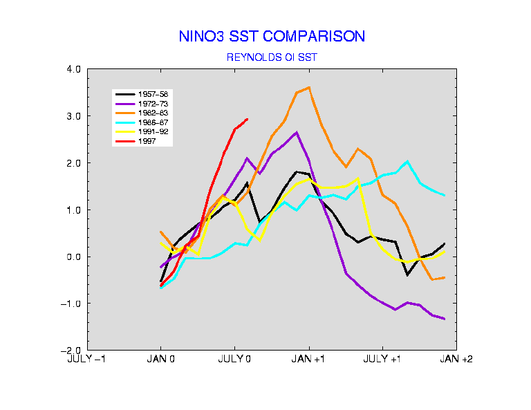 Since the 1997-98 El Niño is stronger than the two previous strong El Niños of recent years, this article will examine some of the unusual characteristics in Alabama's weather following a strong El Niño episode. Figure 1 plots the mean Sea Surface Temperature (SST) anomalies of the equatorial Pacific for the strongest El Niños, along with the 1997 SSTs anomalies. This data clearly shows the 1997/98 event has warmer sea surface temperatures than any previous recorded El Niño. This figure also indicates that the strongest previous El Niños occurred in 1982/83 and 1972/73.
So what's the big deal, Pacific waters off the South American west coast are warmer than normal, and Alabama is more than 3000 miles away? First let's look at Table 1 that compares several measures of Alabama weather with the strong El Niños of 1972/73 and 1982/83. This table accounts for all tornados reported in Alabama for each strong El Niño year and the years just following an El Niño. The table also compares the average of annual precipitation for Alabama, and the mean temperature and snowfall for Huntsville, Birmingham, and Montgomery. At a glance, tornado activity and precipitation seem high after El Niños, while temperature and snowfall tend to run close to normal.
Alabama Weather for the Strongest El Niños |
|||||||||||||||||||||||||||||||||||||||||||||||||||||||
|
|||||||||||||||||||||||||||||||||||||||||||||||||||||||
Percentages above or below normal of Alabama Weather for the Strongest El Niños |
|||||||||||||||||||||||||||||||||||||||||||||||||||||||
|
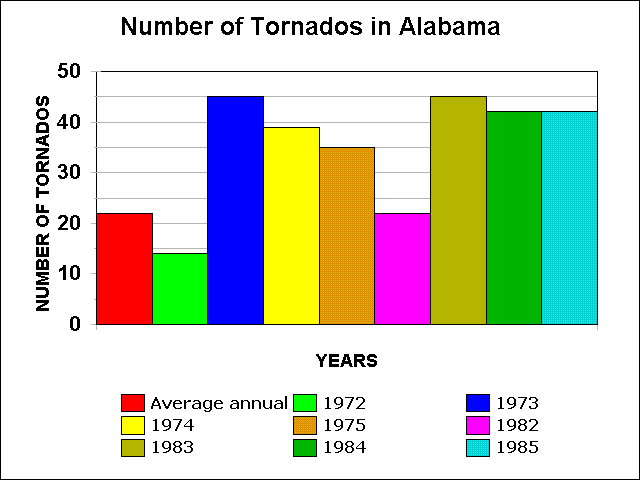 For a more detailed look at the tornado data, Figure 2 compares the number of tornados Alabama experiences in a normal year with the number of tornados after strong El Niño years. Alabama typically has 22 tornados each year. In the previous strong El Niño years of 1972 and 1982, there were 14 and 17 tornados respectively, both years well below normal. But a look at the three years after the onset of these El Niños shows there is a noted increase in the tornado activity across Alabama. 1973, 74, & 75 recorded 45, 39, & 35 tornados. Likewise in 1983, 84, & 85 Alabama recorded 45, 42, & 42 tornados. Not only are the number of tornados exceptionally high in the post-El Niño years, they account for 6 of the 7 years with the most tornados ever recorded in Alabama. To further indicate how rare these numbers are in the past 50 years, the only other year with at least 35 tornados in Alabama occurred in 1957 when 45 tornados were recorded. That year was the onset of the third strongest recorded El Niño. It is interesting to note that all years that have recorded at least 35 tornados have all been either El Niño years or within 3 years of a strong El Niño episode.
In 1997, 29 tornadoes were recorded. If the previous trends hold, one would expect higher than normal tornadic activity across the state through the end of the century.
As for the remaining information in Table 1, while there are no glaring trends that occur with Alabama precipitation during the El Niño onset years, there is a trend for greater than normal precipitation in the years following an El Niño. Temperatures do not show any great variations on an annual basis, and additional examination of temperature data and El Niños are completed later. Surprisingly, when it comes to snowfall in Alabama around El Niño years, there tends to be below normal amounts of snow in the state. Often during El Niño years no measurable snow is recorded, even in the Tennessee Valley.
 We have already seen there was little variation from normal with respect to mean annual temperatures in Alabama for the El Niño years. Figure 3 looks at Alabama's temperatures as a mean departure from normal on a month to month basis following the onsets of strong El Niños. For both the 1972 and 1982, the fall seasons just after the onset of the El Niño saw warmer than normal temperatures. This warm trend continued into the early winter seasons of 1973 and 1983. The data shows a sharp cooling across the state for much of the year following the onset of the El Niño in 1973 and 1983.
A quick conclusion that one may draw from the temperature and precipitation data is that with cooler than normal temperatures and above normal precipitation, there would be an increase in the amount of snowfall across Alabama. Yet, Table 1 indicated there was a tendency to have less snow in Alabama during and following El Niño periods. So what's going on? As mentioned earlier, the energy from the warmer ocean surface is lifted aloft and provides additional energy to the jet streams. During El Niño years the subtropical jet stream across the southern US is enhanced; this tends to increase the cloud cover along the Gulf Coastal States. These clouds not only increase the number of days with precipitation, but they also reduce maximum temperature while increasing the average minimum temperature. So while there is more precipitation, cloud cover tends to reduce the chances for the extremely cold air that is needed to produce snow across Alabama.
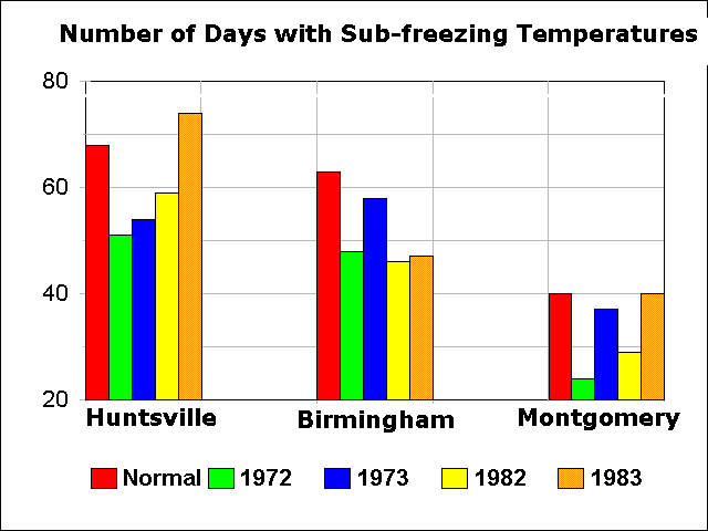 Figure 4 compares the average annual number of days when temperatures fall below 32 degrees Fahrenheit with the onset of El Niño years and the year following the El Niño onset for the three major cities in interior sections of Alabama. In almost every case the number of sub-freezing days in either the El Niño onset year or the following year recorded fewer than normal sub-freezing days. Specifically, for the Huntsville area, there were 12% fewer sub-freezing days during EL Niño years, the Birmingham area saw a 21% decrease in the average number of sub-freezing days, while the Montgomery area experienced a 19% decrease in sub-freezing days.
So what should Alabamians expect for the upcoming winter of 1997/98 and for the remainder of 1998? Certainly no one should jump to conclusions regarding the impact of the El Niño of 1997/98, since there is not enough data to make definitive correlations. In addition, varying strengths of each El Niño may have different impacts. However, there has been a tendency associated with strong El Niños to anticipate the following conditions in Alabama:
Time will tell what Alabama's weather will be after the 1997/1998 El Niño. Whether or not there is a true relationship between Alabama's weather and El Niños; Alabamians need to be prepared for whatever Mother Nature offers.

