|
2015 A fairly uneventful hydrologic year for most of Central Alabama…until Christmas!
The weather story for 2015 in Central Alabama precipitation-wise was one of above normal rainfall in some areas, with frequent and sometimes heavy precipitation, while other areas received below normal rainfall. With this said, there were no major flood events on area main-stem rivers and mostly localized, sporadic episodes of flash flooding. Yearly rainfall totals averaged between forty and sixty inches across Central Alabama, with localized amounts over sixty five inches.
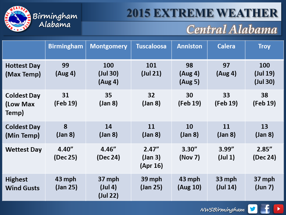
The year began with fairly typical January rainfall averaging from four to six inches across the area. Much of this fell during the first few days of the month and produced some minor flooding on portions of the Black Warrior, Cahaba, Tombigbee and Sucarnoochee Rivers, as well as flooding of many small streams in Lamar County and some localized street flooding in portions of Pickens and Tuscaloosa Counties. As we moved into February below normal rainfall was observed with no significant flooding observed. The most interesting precipitation event of February occurred on the 25th when snowfall of four to ten inches with some localized totals near one foot occurred north of a line from Tuscaloosa to Birmingham to Anniston.
The main spring flood season was a relatively quiet one across Central Alabama as the March through May time period saw periodic heavy rainfall events, but only very limited river flooding. Heavy rainfall during the first part of March produced minor flooding at the Bevill Lock and Dam on the 11th and 12th but only moderate rises elsewhere. April was a wet month, with rainfall averaging between four and ten inches. However, only Selden Lock and Dam reached flood stage when minor flooding occurred from the 19th through the 22nd. This followed heavy rainfall of four to eight inches that gradually accumulated from the 13th through the 18th. Two to five inches of rain to the south and east of this area produced rises to above caution stages on portions of the lower Cahaba, Alabama and lower Tallapoosa Rivers. Rainfall was below normal in May with no flooding observed in Central Alabama.
As Central Alabama moved into its summer season, summertime thunderstorms continued to produce episodes of localized, heavy rainfall and isolated flash flooding. On June 1st, two to three inches of rain produced street flooding in Ragland, and water entered a home in Ohatchee. On June 9th, three to five inches of rain in Prattville produced considerable street flooding with several roads barricaded during the event. In July, heavy rainfall during the morning of the 3rd produced road and street flooding in Lamar County. Heavy rainfall on July 4th produced flash flooding in southern Jefferson County, with water rescues needed from an apartment complex near Shades Creek. Otherwise, the remainder of July and August only saw fairly isolated, nuisance type flooding from localized heavy rainfall in summertime thunderstorms.
Drier weather returned in September, with below normal rainfall and no flooding issues. This continued through October into mid-November. However, two to four inches of rain from November 16th to 18th occurred and produced rises on the Alabama River at Montgomery to above its caution stage.
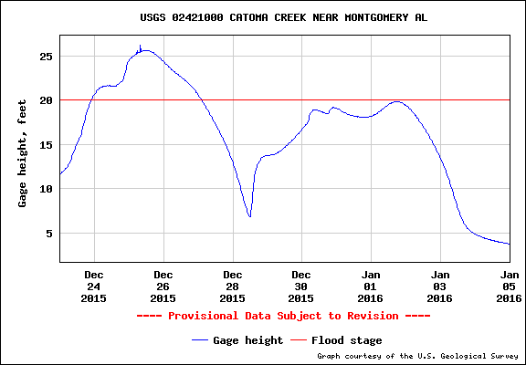
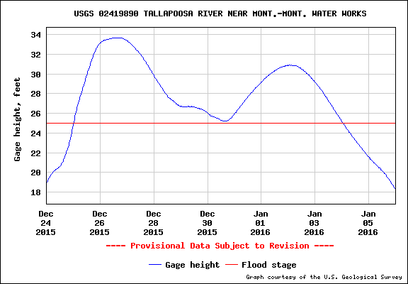
As we moved into December, heavy rainfall events continued to occur over the area, but with these coming several days apart and streamflows not very high, runoff was able to move downstream without producing any rises of significance…until Christmas! On Christmas Eve Day, heavy rain fell over the southeastern counties of Central Alabama with widespread flash flooding occurring over portions of Randolph…Lee…Macon…Bullock…Elmore…Mongomery…Russell…Pike and Barbour Counties. Numerous roadways were flooded and many closed across these areas…with flooding of some residences in localized areas. Then…on Christmas Day additional heavy rain fell over much of Central Alabama once again producing widespread flash flooding with numerous roadways flooded and impassable as well as some bridges and culverts washed out. Some homes were also flooded in areas such as Pratt City and some water rescues became necessary. Additionally, widespread river flooding developed on most area main stems following this rainfall. Most of the river flooding was minor, although moderate flooding occurred at a few locations across the area. Three day rainfall totals from the 23rd to the 26th averaged four to eight inches in many areas, with localized amounts over ten inches. Although levels were starting to recede somewhat, widespread river flooding was still in progress across much of Central Alabama as 2015 came to an end. Below are a few of the locations that experienced river flooding at the end of December.
|

|
|

|
| Bevill L&D - Tombigbee River |
Montgomery - Catoma Creek |
Childersburg - Coosa River |
|

|

|

|
| Demopolis - Tombigbee River |
Montgomery - Alabama River |
Sayre - Locust Fork |
|

|
|
|
| Seldon - Black Warrior River |
Tallapoosa W.P. - Tallapoosa |
|
Data supplied by the NWS BMX. Additional Flood Information can be found at the following links:
|

|

|
| 2015 Precipitation Totals |
2015 Precipitation Extremes |
|
|

|
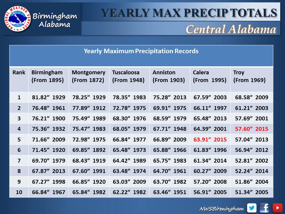
| Yearly Maximum Precipitation Totals |
Yearly Minimum Precipitation Totals |
|

|

|
| 2015 Total Rainfall |
2015 Rainfall Departure |
|

|

|

|
| January Total Rainfall |
February Total Rainfall |
March Total Rainfall |
|

|

|

|
| April Total Rainfall |
May Total Rainfall |
June Total Rainfall |
|

|

|

|
| July Total Rainfall |
August Total Rainfall |
September Total Rainfall |
|

|

|

|
| October Total Rainfall |
November Total Rainfall |
December Total Rainfall |
|


