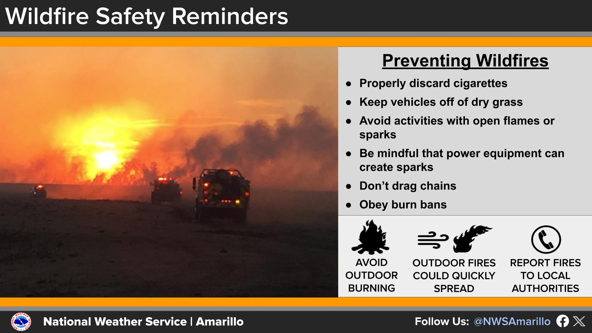
National Weather Service United States Department of Commerce

Rain Coming to Drought-Stricken Southern U.S.

A storm tracking across the Southern U.S. will bring heavy to excessive rainfall over portions of west-central Texas into tonight then from central Texas through the central Gulf Coast on Friday. The Southeast U.S. will see heavier rain Saturday. While much of this rainfall will be beneficial to the drought, excessive rainfall may bring areas of flash and urban flooding. Read More >

Click a location below for detailed forecast.

Last Map Update: Thu, Apr 30, 2026 at 4:22:27 pm CDT

The southwestern portion of our forecast area has the highest chances to see rainfall as we head into the weekend. However, recent trends have continued to track the low-pressure center further south, restraining higher precipitation amounts (> .25") to the southwest corner.
Temperatures in the western combined Panhandles will approach freezing on Saturday morning. To protect sensitive plants, move them inside Friday night!
As we head into the weekend, we will see some cooler temperatures take over. Highs in the 50's and low-60's are most likely, with precipitation chances both Thursday and Friday. Frost conditions or even a light freeze will be possible for portions of the Panhandles Saturday morning.

Text Product Selector (Selected product opens in current window)


Current Observations ( )
Location Sky/Weather Temp (°F) Dewpt (°F) RH (%) Wind (mph) Pressure (inHg) Remarks
 Amarillo
N/A
N/A
N/A
N/A
N/A
N/A
N/A
 Borger
N/A
N/A
N/A
N/A
N/A
N/A
N/A
 Canadian
N/A
N/A
N/A
N/A
N/A
N/A
N/A
 Dalhart
N/A
N/A
N/A
N/A
N/A
N/A
N/A
 Dumas
N/A
N/A
N/A
N/A
N/A
N/A
N/A
 Guymon
N/A
N/A
N/A
N/A
N/A
N/A
N/A
 Hereford
N/A
N/A
N/A
N/A
N/A
N/A
N/A
 Pampa
N/A
N/A
N/A
N/A
N/A
N/A
N/A
 Perryton
N/A
N/A
N/A
N/A
N/A
N/A
N/A
 Amarillo 9NNE
N/A
N/A
N/A
N/A
N/A
N/A
N/A
 Amarillo 7SSE
N/A
N/A
N/A
N/A
N/A
N/A
N/A
 Bootleg 11WNW
N/A
N/A
N/A
N/A
N/A
N/A
N/A
 Canadian 6E
N/A
N/A
N/A
N/A
N/A
N/A
N/A
 Clarendon 2WSW
N/A
N/A
N/A
N/A
N/A
N/A
N/A
 Claude 12SW
N/A
N/A
N/A
N/A
N/A
N/A
N/A
 Hereford 2NW
N/A
N/A
N/A
N/A
N/A
N/A
N/A
 McLean 1E
N/A
N/A
N/A
N/A
N/A
N/A
N/A
 Palo Duro SP
N/A
N/A
N/A
N/A
N/A
N/A
N/A
 Pampa 2E
N/A
N/A
N/A
N/A
N/A
N/A
N/A
 Umbarger 3NNE
N/A
N/A
N/A
N/A
N/A
N/A
N/A
Note: "N/A" or "MISG" will be displayed if values are not available. In the LOCATION column, click on links for a list of recent observations at sites of interest. In the WIND column, VRB is "variable" and G is "gust". In the REMARKS column, HX is "heat index", WCI is "wind chill index", and VSB is "visibility" (if shown).


Aviation Drought Fire Weather Hydrology Severe Weather Winter Weather
 
Climate Graphs Hourly Forecast Long Range Local Model Data Precip Maps Heat
 
Education Local Research News Skywarn Weather Calculator Weather Radio