Below Normal Reports of Severe Weather in 2013
Thus far, the summer of 2013 has experienced a below normal number of severe thunderstorms in the NWS Aberdeen forecast area. The NWS Aberdeen forecast area encompasses much of central, north-central, and northeastern South Dakota, and Big Stone and Traverse Counties in Minnesota (see Figure 1).
Figure 1: NWS Aberdeen Forecast Area

Recall that severe thunderstorms are those producing at least one of the following:
1. Tornado
2. Hail greater than 1.0” in diameter
3. Winds at or above of 58 mph
One easy way to assess the trends in severe weather is to examine the total number of severe thunderstorm warnings (SVR) and tornado warnings (TOR) issued per year. In fact, the severe weather season in 2013 is on track to see the least number of total warnings issued by NWS Aberdeen dating back to 1995 (Figure 2).
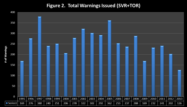
The highest number of total warnings issued was back in 1997 with a combination of 380 warnings. The lowest number of warnings was issued is 169, set in 1995 and again in 2009. The average number of warnings issued by year is about 261. It is also important to note that in 2007, the NWS changed the warning methodology to a storm based warnings (SBWs) approach. Prior to 2007, warnings were issued by entire counties.
Why has this severe weather season been so slow?
As is usually the case, there is not one underlying reason for the lack of severe weather, but rather a combination of issues. Recall that the basic ingredients for severe storms are moisture, instability, lift, and wind shear. Often times this spring/summer, these ingredients tended to be out of phase. In other words, by removing any one of these ingredients, organized severe storms become unlikely. Several other relevant climate trends that stand out from this spring/summer include:
· Colder than normal conditions in April and May led to a slow start to the season
· Cooler than normal conditions redeveloped in July and early August
· Predominate northerly wind flow kept Gulf moisture south of the region which resulted in drier than normal conditions in mid-July through mid-August
· There were few potent low pressure systems this severe weather season

