Event Summary:
A powerful storm system that produced record low surface pressure levels over Minnesota and Wisconsin (click HERE for more details) will continue to lift northeastward through Ontario Canada tonight. High Wind Warnings remain in effect across South Dakota and west-central Minnesota through Wednesday evening as winds will continue to gust over 50 mph at times. See below for a listing of the peak wind gusts reported over the NWS Aberdeen forecast area.
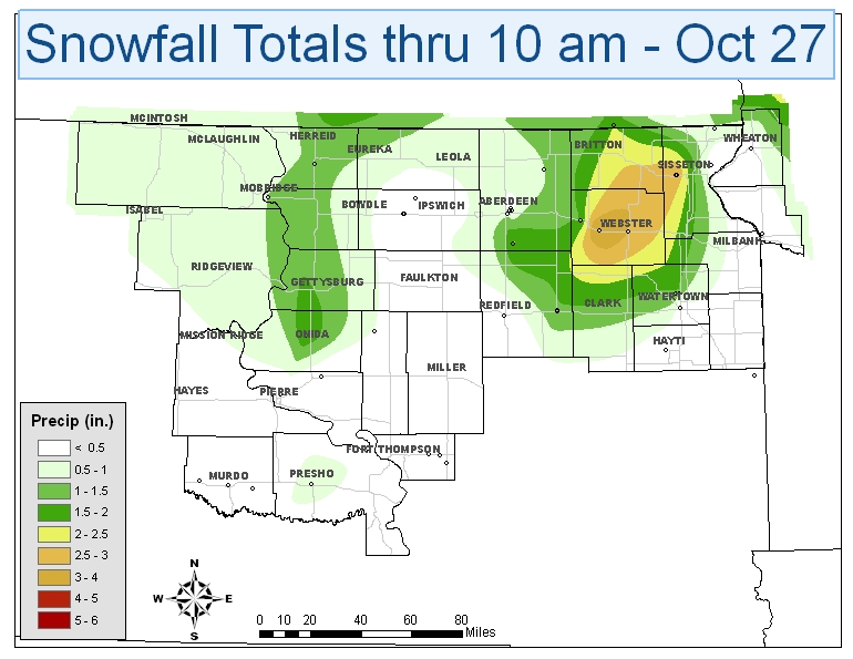
In addition, periods of light snow are also expected to continue through evening although any additional snow accumulations should be an inch or less. Conditions will slowly improve tonight and Thursday although temperatures will remain well below normal. A storm total snowfall map with reports through 10am CDT on Wednesday is shown below.
Storm Total Snowfall Map:
Peak Wind Gusts:
BELOW IS A SUMMARY OF THE PEAK WIND GUSTS REPORTED IN THE NWS
ABERDEEN FORECAST AREA. REPORTS ARE A COMBINATION OF AUTOMATED
WEATHER STATION REPORTS AND COOPERATIVE OBSERVER REPORTS. ALL VALUES
ARE VALID AS OF 9AM CDT ON OCTOBER 27TH.
ASOS/AWOS...
PIERRE (KPIR)...............67 MPH
MOBRIDGE (KMBG).............64 MPH
SISSETON (K8D3).............64 MPH
ABERDEEN (KABR).............62 MPH
WATERTOWN (KATY)............61 MPH
ORTONVILLE MN (KVVV)........58 MPH
WHEATON MN (KETH)...........56 MPH
RAWS/SOUTH DAKOTA STATE UNIVERSITY MESONET/COOPERATIVE REPORTS...
GRAND RIVER RAWS............75 MPH
ONIDA AIRPORT...............73 MPH
CASTLEWOOD COOP.............63 MPH
FT. PIERRE RAWS.............62 MPH
MARSHALL COUNTY RAWS........62 MPH
SAND LAKE RAWS..............61 MPH
OACOMA SDSU.................60 MPH
LEOLA SDSU..................57 MPH
EAGLE BUTTE SDSU............56 MPH
BOWDLE SDSU.................55 MPH
MCINTOSH SDSU...............55 MPH
TIMBER LAKE SDSU............55 MPH
SOUTH SHORE SDSU............55 MPH
BEAR CREEK RAWS.............54 MPH
FAULKTON SDSU...............51 MPH
BIG STONE RAWS..............51 MPH

