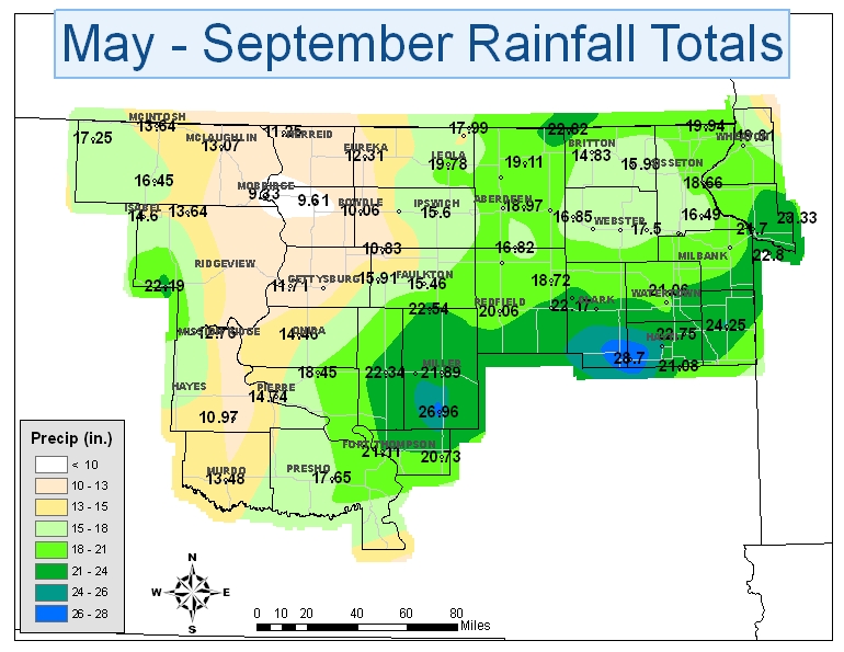
The 2010 convective season rainfall (May through September) across central and northeast South Dakota as well as west central Minnesota varied from very dry to extremely wet. While areas across north central South Dakota were experiencing worsening drought conditions throughout much of the summer, parts of central and northeast South Dakota were experiencing frequent periods of heavy rain with the subsequent flooding conditions. The drought conditions across north central South Dakota did improve during September as rainfall returned to the area. The hardest hit areas with frequent bouts of heavy rainfall were from Buffalo County up through Hyde, Hand and Spink counties and east through Clark, Hamlin, Codington, Grant, Deuel, and Big Stone counties.
The May through September rainfall map shows how the rainfall varied across the region. The five-month rainfall for several locations in north central South Dakota was just around 10 inches. Locations from central to northeast South Dakota from Fort Thompson to Highmore east over to Bryant, Clear Lake, and Ortonville, Minnesota received anywhere from 20 to 29 inches. Mobridge was the driest location in north central South Dakota with 9.33 inches of rainfall. Bryant, in northeast South Dakota, received the most rainfall in the five-month period with 28.70 inches which is nearly two and a half feet of rainfall.
One of the more dramatic rainfall differences across a short distance was from Onaka to Orient in Faulk County. Within a 30 mile distance, the rainfall ranged from 10.83 inches at Onaka to 22.54 inches at Orient, nearly 12 inches. Other areas of interest were in western Dewey County (22.19 inches at Eagle Butte) and in Northwest Marshall County (22.82 inches 9 miles northwest of Britton). In Western Dewey County, Eagle Butte received 10.50 inches in June which was predominantly from a slow moving supercell thunderstorm. The nearly 23 inches of rainfall northwest of Britton in northwest Marshall County was the result of many thunderstorms rolling across the region. Finally, the most interesting fact about the May through September rainfall amounts was that many of these amounts were near to above the total yearly (January through December) normal precipitation amounts for these locations. In fact, many locations from central through northeast South Dakota and into west central Minnesota were from 1 to 2 inches above their yearly averages with Bryant nearly 4 inches above its yearly average precipitation.