While many significant weather events affected many across central and northeast South Dakota and west central Minnesota in 2016, below is a listing of the top 5 events of the year in terms of scope, severity of impacts, and/or rarity. In chronological order:
June 14th Tornadoes
An area of northeastward-lifting low pressure traveled across northeastern South Dakota and produced showers and thunderstorms along the way (over an inch of rain in some cases). As thunderstorms formed during the afternoon and early evening along a warm which extended into west central Minnesota, 6 confirmed tornadoes developed across Day, Grant, Roberts, Big Stone and Traverse counties. The environment for severe weather was somewhat atypical, as there were no reports of large hail or damaging winds. Instead, a very sheared and moist environment was enough for weak tornado formation (all 6 were rated EF-0). The longest-tracked tornado developed at 4:14 pm 4 miles west of Corona and traveled north 5.6 miles before lifting near Wilmot, MN. Minor damage resulted with this particular tornado as it tracked over a farmstead. For more information, visit http://www.weather.gov/abr/June142016Tornadoes
Photo courtesy of Marie Johnson, on Hwy 12 west of Webster

August 9-10th Bow Echo
Severe thunderstorms developed in a volatile atmosphere across northern South Dakota during the evening of August 9th and early morning hours of August 10th. A slow moving supercell produced baseball sized hail, damaging winds and funnel clouds northwest of Eureka around 11 pm. Around the same time, a bow echo began impacting Corson county, and it would travel east across the state and into west central Minnesota over the next several hours. During this time, large hail, heavy rain, and wind gusts to 90 mph were produced. Some of the hardest hit areas were across Marshall and Edmunds counties. There were numerous reports of damage to trees and structures with this event. For more information, visit http://www.weather.gov/abr/2016_08_09_StormSummary
Photo courtesy of the Edmunds County Emergency Manager, at the Trail Days site.

August 11th Flooding
An active pattern set up across South Dakota from August 9-11th, in which round after round of severe storms and heavy rain developed and moved east. The last round in this series developed in a very moisture-laden environment across eastern South Dakota on Thursday evening, August 11th, and produced very heavy rainfall primarily across Clark, Codington, Hamlin, and Deuel counties. Flooding resulted, with Watertown, SD being among the hardest hit. A total of 3.90" of rain was recorded at the Watertown airport on August 11th, which broke the previous daily rainfall record of 1.66" in 1974. Amazingly, 3.29" of that total fell during a one hour period from 11 pm to midnight, and 1.29" of that amount fell within a 12 minute period from 11:10-11:22 pm. A rescue was required on Hwy 20 as multiple vehicles had stalled in the water. For more information, visit https://www.weather.gov/abr/August11thStormsandFlooding
Photo courtesy of Angela Hillberg, in Watertown.

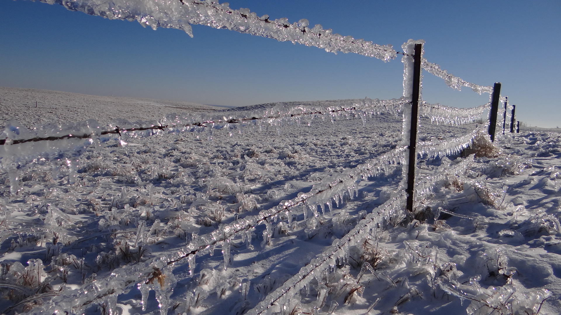
Christmas Winter Storm
A significant winter storm encased in ice, buried under snow, and even flooded South Dakotans on December 25th. Additionally, high winds from teh 25-26th exacerbated power outages and led to blizzard conditions across much of the state. Hundreds of power poles went down leaving thousands without power (at least 17,000 at one point on the 26th). This was one of the worst ice storms to affect South Dakota since the November storm of 2005, as over 1" accumulations were observed across northeastern and north central South Dakota. Daily precipitation amounts in Mobridge and Aberdeen of 1.52" and 1.28" broke records for their wettest December day, and Mobridge their wettest winter (Dec-Feb) day. Thunder and lightning was also reported across the area this Christmas day/evening. Many soaked roadways froze overnight on the 26th and blizzard conditions set in with 60+ mph wind gusts. People were still without power in some cases 5+ days after the storm. Sadly, this storm proved fatal as well. For more information, visit https://www.weather.gov/abr/2016ChristmasStorm
Photo courtesy of a NWS employee, along Hwy 12 near Summit on the 27th.
Very Warm Year
2016 will go down as the 2nd warmest in Mobridge's recorded history, 3rd for Watertown, 5th for Aberdeen, 6th for Sisseton, Timber Lake, and Kennebec, and 11th for Pierre. The abnormally warm winter of 2015-2016, thanks to a very strong El Nino event, started the year off to a warm start. All-time record February high temperatures were recorded at Mobridge and Kennebec with 73 and 76 degrees respectively, and many locations recorded top 10 warmest winters on record. A top 5 warmest March on record was also observed for many, and combined with below average precipitation, moderate drought conditions developed and lasted into April+. An active fire season ensued as well. Finally, a record-breaking warm November at Mobridge and Sisseton and a top 3 warmest November for many others put 2016 on track for one of the warmest on record. In fact, flowers were still in bloom well into November, and many locations had frost-free ground as of the 1st of December.
Flowers in bloom on November 8th in Pierre. Photo courtesy of Rob Fines.

Honorable Mentions
February 19-20th high wind event across central SD, July 13th heavy rains across northeastern SD and west central MN, the active severe weather pattern in July and August, November 17-18th blizzard across eastern SD and west central MN, Nov 28-30 record-breaking low pressure rain/snowstorm, and the December 17-18 arctic cold air outbreak.
2016 was an exceptionally warm year, across the entire nation, thanks in part to a strong El Nino 2015-2016 winter and a record-breaking March and November. According to Brian Brettschneider (@Climatologist49), an average of 66% of all days in 2016 were above normal in the U.S. And in Alaska, the average was an amazing 75%. The image below shows particular relative hot/cool spots. Much of our area was in the 65-70% range. Pierre observed their 11th warmest year on record, Sisseton, Timber Lake and Kennebec their 6th warmest, Aberdeen 5th, Watertown 3rd, and Mobridge 2nd.
Below are summaries that address overall weather and specific events for each of the months of 2016, as well as a table and maps of overall precipitation and temperature information:
January 2016
The warmer than normal temperatures continued into the new year across much of central and northeast South Dakota along with west central Minnesota. Average temperatures were anywhere from near normal at Pierre, Kennebec, and Timber Lake, up to nearly 6 degrees above normal at Aberdeen. With all of the cloud cover and lack of snow on the ground, low temperatures were from 1 to 7 degrees above normal. A couple Arctic outbreaks brought some cold temperatures and low wind chills to the region during the middle of the month. Wind chills on the 16th were from 30 to 50 degrees below zero across the region. Much above normal temperatures occurred at the end of the month with highs in the 40s.
The precipitation for January 2016 was below normal at all locations with Watertown being closest to normal. Being six tenths of an inch of precipitation below normal, Wheaton was the driest in the area. January snowfall at Watertown finished the month with 8.5 inches, which is 3 inches above normal.
February 2016
February 2016 was a very warm month across central and northeast South Dakota as well as west central Minnesota. Average monthly temperatures ranged from 6 degrees above to 11 degrees above normal with many locations having their top ten warmest Februarys on record. Mobridge had their third warmest on record with Pierre and Timber Lake having their seventh and sixth warmest respectively. Aberdeen was the ninth warmest on record. Kennebec finished just outside the top ten having their eleventh warmest February on record. At the end of the month on February 27th, an abnormally warm air mass brought record highs for most all locations across the region. In fact, all-time February record highs were set at Mobridge and Kennebec with 73 and 76 degrees, respectively. The 68 degrees at Aberdeen was the second warmest temperature ever recorded in February.
The precipitation across the region varied quite a bit with around a tenth of an inch at Kennebec and over an inch of precipitation at Mobridge. Kennebec was nearly four tenths below normal with Mobridge over six tenths above normal.
There were several notable weather events throughout February. High winds occurred on Feb 7th and again on the 19th. On February 7th, winds gusted to 60 to 70 mph. The winds during the early morning hours on February 19th were even stronger, gusting up to 70 to over 80 mph across central and north central South Dakota. This includes a 78 mph gust at Pierre and an 83 mph gust near Hayes. The system that brought these damaging winds was warm enough to produce rain and lightning/thunder in areas as well. A freezing rain and heavy snow event occurred on the 13th and 14th. The freezing rain brought icing up to a tenth to isolated quarter inch amounts across parts of central South Dakota. Snowfall across the region ranged from 2 inches up to a foot in some locations. Finally, a leap day (Feb 29th) snow event led to a narrow swath of 4-8 inches of snow across central South Dakota.
March 2016
The average temperatures for March 2016 across central and northeast South Dakota as well as west central Minnesota were much above normal with all locations having one of their top ten warmest March’s on record. The average monthly temperatures for March were from 6 to 10 degrees above normal (shown in the graphic below). Just four years ago in 2012, March was the warmest on record with average monthly temperatures an astounding 12 to 15 degrees above normal (shown in the graphic below). For comparison, the highs for March 2016 at all locations were in the 70s with 80s for highs in March 2012 with some locations in 2012 setting all-time record highs for the month. For March 2016, Mobridge had their second warmest month on record with Watertown having their third warmest on record. Aberdeen had their fourth warmest March on record with Sisseton and Wheaton, Minnesota having their fifth warmest. All locations set several record daily highs in March along with several record low maximums with all of the records occurring before the 15th of the month. The record low maximums were in the upper 30s and 40s. In fact, Watertown only cooled to 47 degrees on March 13th, which is 10 degrees warmer than the previous record and almost 30 degrees above the normal low.
The region was also generally dry in March with precipitation amounts varying from a quarter of an inch at Watertown to an inch and a third at Pierre. The departure from average precipitation across the region ranged from a tenth of an inch above normal at Pierre to over an inch below normal at Wheaton, Minnesota (shown in the graphic below). Snowfall amounts across the region were generally below 2 inches in March, with the heaviest snow occurring in central South Dakota. Pierre also received heavy rain on March 9th with just over eight tenths of an inch along with some rare thunder. Another interesting point for March is that Aberdeen failed to measure more than a trace of snow depth which is something that has only happened six other times since 1940.
April 2016
The month of April began dry with drought conditions expanding across the region. Moderate drought conditions had expanded into northeast South Dakota early in the month. With the dry conditions and brown grasslands, the fire danger ranged from very high to extreme several times early in April with several Red Flag Warnings being issued. In the middle of the month, the faucet opened up and heavy rainfall occurred across most of the region with another big rainmaker occurring toward the end of the month. As a result of these systems, the precipitation for April was much above normal for most locations except the far east where precipitation values came in a quarter of an inch or less above normal. The drought conditions were pretty much eliminated with 2 to 6 inches of rainfall for the month. These amounts ranged from near normal in the far east to 3 to 4 inches above normal across north central South Dakota. Finally, April 2016 was one on the top ten wettest Aprils on record for a few locations. Mobridge ended up with the wettest month on record while Timber Lake was the second wettest on record. Pierre finished out with the sixth wettest April on record. The string of above normal temperature months continued across the region in April with monthly average temperatures ranging from just slightly above normal to nearly 3 degrees above normal.
May 2016
Average monthly temperatures for May across central and northeast South Dakota as well as west central Minnesota ranged from a degree below to nearly 3 degrees above normal. The warmest part of the month was surprisingly early, from May 5th to May 7th, when temperatures soared into the upper 80s and lower 90s. Record highs were set on May 6th at Aberdeen, Watertown, and Sisseton. However, not soon after, in the middle of May, there were a couple of days with damaging sub-freezing temperatures. Readings in the mid 20s to the lower 30s were recorded across the region.
Precipitation for May was generally below normal with amounts ranging from a half inch to nearly 2 inches below normal. The driest areas were across northeast South Dakota and west central Minnesota along with areas west of the Missouri river. A wetter than normal area was located in north central South Dakota. Mobridge received nearly 4 inches of precipitation which is nearly an inch above normal.
Severe weather got off to a late start this spring with the first warning not being issued until May 22nd. This tied for the latest date of the first severe weather warning issuance by the NWS in Aberdeen since records began in 1986. Nevertheless, a couple weak landspout tornadoes occurred, the first of which northeast of Herreid in Campbell County on May 22nd. It was on the ground for about 4 miles with no damage reported. The second tornado, another landspout, touched down southwest of Bowdle on May 28th and lasted only a few minutes producing no damage. Another storm produced large hail from golf ball to baseball size on May 25th from Hughes through Hand counties. The result was damage in varying degrees, including several broken vehicle windshields.
June 2016
June 2016 was a very warm and dry month across central and northeast South Dakota as well as west central Minnesota. The average monthly temperatures were from 4 to 6 degrees above normal. In fact, most all locations had one of their top fifteen warmest Junes on record. The June heat for 2016 paled in comparison to the extreme heat of June of 1988 when the average temperatures ranged from 7 to 12 degrees above normal. Several 100 degree readings occurred in June 2016 with Aberdeen tying a record set back in 1933 on the 9th with 100 degrees.
Rainfall for the month was anywhere from 1 to 4 inches across the region ranging from just above normal to nearly 3 inches below normal.
Severe weather for June was minimal across the region. The most notable event for the month was on June 14th, when a strong upper level low pressure area moved across our region and brought widespread rainfall along with several weak tornadoes. Six weak tornadoes touched downed in northeast South Dakota and west central Minnesota with minimal damage.
July 2016
July temperatures were generally near normal across central and northeast South Dakota as well as west central Minnesota. The average temperatures were mostly within a degree of normal with the exception of Mobridge where the average temperature was 3 degrees above normal. Highs for the month were in the 90s across the east with 100s across the western part of the region. Pierre topped out at 109 degrees on July 20th. Excessive heat was an issue across the region from the 19th through the 22nd. The combination of highs in the 90s and 100s along with dew points in the upper 60s and 70s brought very uncomfortable heat indices in the daytime along with the nighttime.
The rainfall across the region for the month varied quite a bit ranging from a half inch below normal at Watertown to over 3 inches above normal at Wheaton, Minnesota. Rainfall amounts of 3 to 7 inches over northeast South Dakota and west central Minnesota helped relieve the drought conditions. While this area experienced some relief, the drought conditions expanded across central South Dakota with rainfall amounts ranging from 1 to 2 inches below normal. The maps below show the total rainfall for July along with the departures from normal.
July was also an active weather month with many rounds of severe thunderstorms affecting the region with large hail and damaging winds.
August 2016
August temperatures were generally near normal across central and northeast South Dakota as well as west central Minnesota. The average temperatures were mostly within a degree or two of normal, with a more focused pocket of below averages at and southwest of Pierre. While no major heat waves were observed, several locations reached the century mark of 100 degrees, including Pierre, Mobridge, and Timber Lake. Many areas further east topped out in the lower 90’s, in part due to higher humidity making for oppressive heat index values at times.
Precipitation amounts are the bigger story this month. While much of the area observed above average rainfall, eastern South Dakota and west central Minnesota recorded the most. For instance, parts of Codington, Hamlin, Deuel, and Grant counties picked up 3-4” above average rainfall. Watertown was particularly hard-hit with a total of 6.98” of rain. This ranks 3rd place since 1893 for most rainfall in the month of August, beat only by 7.4” in 1916 and 7.67” in 1900. Amazingly, 5.29” of 2016’s total fell during a 24 hour period from August 10th-11th when back-to-back squall lines impacted the city which resulted in flooding on the evening of the 11th. However, parts of Hand, Hyde, Sully, Potter, Faulk, Corson, and others at the end of the month remained in D1/Moderate Drought as identified by the US Drought Monitor.
Several rounds of severe thunderstorms also impacted the region this August. The largest outbreaks of large hail and damaging winds occurred on the 9th when a bow echo moved across the North Dakota/South Dakota state line into west central Minnesota, and then on the 10th when several storms developed along a cold front across central and northeast South Dakota. Preliminarily, no tornadoes were observed across our County Warning Area.
September 2016
September 2016 was a warmer than normal month across central and northeast South Dakota along with west central Minnesota. Average temperatures were from one to more than 3 degrees above normal across the region. Most locations only fell into the mid to upper 30s in September with only a few dipping to 32 degrees or below. Normally, the first freeze (32 degrees or lower) occurs during the last 10 days of September for the entire region. A hard freeze (28 degrees or lower) usually occurs during the first 10 days of October.
In terms of precipitation, far southeastern South Dakota picked up a great deal of moisture this month, but the rest of us were only slightly above or below normal (varying quite a bit from spot to spot). Overall, there were only a few minor severe events this September. The 4th featured a few reports of large hail and strong thunderstorm winds, and tennis ball sized hail fell in Spink County on the 7th. Otherwise, very quiet!
October 2016
October 2016 was a warm month across central and northeast South Dakota as well as west central Minnesota. October average temperatures were anywhere from 1 to 6 degrees above normal across the region. Several locations had one of their top fifteen warmest October’s on record including Pierre, Kennebec, and Mobridge.
Most of the region had below normal precipitation for October, especially across central and north central South Dakota. An exception is northeastern South Dakota and west central Minnesota, which ended up with 0.5 to 2.0 inches of above normal precipitation thanks to an upper level low pressure system that lifted across the region at the end of the month.
November 2016
November 2016 was incredibly mild, enough so to break a number of records. The warmest stretch occurred from the 3rd through the 5th as temperatures soared into the 70s and even lower 80s for some. For example Aberdeen broke a record high on the 5th of 76 degrees and Pierre tied their record of 80 degrees. However, record high max temperatures were tied or broken at at least one location in South Dakota nearly every day from November 1st to the 14th. For a complete list, visit: www.ncdc.noaa.gov/cdo-web/datatools/records and click the “View Selected Records” tab. Over the course of the month, the following records for number of days at or above 70 degrees were set: 7 in Pierre (7 in 1999), 2 in Watertown (2 in 2001, etc), 6 in Timber Lake (4 in 1999), 4 in Sisseton (3 in 2001, etc), and 5 in Mobridge (5 in 1914). As a result of the widespread and prolonged warmth, many locations recorded a top 3 warmest November on record: 3rd place at Kennebec, Wheaton, MN, and Pierre, 2nd place at Aberdeen, Watertown, and Timber Lake, and 1st place at Mobridge and Sisseton. Not surprisingly, flowers were still in bloom well into November this year, and many locations still have frost-free ground as of the 1st of December.
The area was generally at or above average in terms of precipitation, with the bulk of the moisture having fallen across northeastern South Dakota and west central Minnesota. Snowfall amounts generally ended up around normal, with two major systems of note
Two major storm systems affected our region in November with first one on the 18th with the second prolonged event from November 26th-30th. Northeast South Dakota and west central Minnesota received the brunt of the 18th storm with 3 to 9 inches of snow along with 50 to 70 mph wind gusts creating blizzard conditions. From November 26-30th, a record breaking low pressure area affected mainly central South Dakota where 4 to 10 inches of snow fell and the strongest winds occurred. With warm air wrapping into the east, rain was the predominant precipitation with only 1 to 3 inches of snowfall. If this low pressure area had tracked farther east, our region could have received what occurred across central and western North Dakota where 12 to 18 inches of snow fell. For example, Sisseton received a total of 1.22 inches of precipitation with only two tenths of inch of snow. This could have easily been a foot or more of snow with colder temperatures.
The record breaking low pressure area on November 28th had a minimum value of 975.9 millibars or 28.82 inches of mercury at Aberdeen. This broke the old record low November pressure of 982.7 millibars or 29.02 inches of mercury, set on November 1st, 1961. In addition, this tied for the second lowest pressure of all time in Aberdeen, South Dakota. The all-time lowest pressure recorded in Aberdeen is 973.2 millibars or 28.74 inches of mercury, set on October 10, 1949.
December 2016
A weak La Niña helped influence below average temperatures across the area this December. Deeper/persistent snowpack across central South Dakota enhanced/entrenched the cold there. Timber Lake for instance experienced their 6th coldest December on record. The coldest air of the month gripped the region from the 17th into the 18th. By Sunday morning (the 18th), temperatures had dropped to 37 degrees below zero at Watertown and Aberdeen, and well into the 20’s below zero elsewhere. That set an all-time December record for Watertown, surpassing the previous record of 33 degrees below zero set on the 31st in 1967. Wind chill values also reached dangerous levels: 58 degrees below zero was recorded at Aberdeen with values in the 30’s to 40’s below zero elsewhere.
Precipitation-wise, it was a very wet and snowy month. In terms of total precipitation, Kennebec, Aberdeen and Sisseton all ranked as top 10 wettest Decembers, Pierre ranked 4th wettest with 1.71”, Timber Lake 3rd with 1.94”, and Mobridge smashed their record with 2.30” (1.41” in 1911). In terms of total snowfall, Watertown ranked as their 10th snowiest December, Timber Lake 4th with 16.4”, and Mobridge tied 3rd with 17”. December 25th, the Christmas Winter Storm, was an exceptional December day in terms of precipitation. Timber Lake’s 0.73” of liquid made it the 8th wettest December day on record, Kennebec’s 0.57” was 7th. Pierre picked up 0.92” of moisture, making Dec 25th, 2016 their 2nd wettest December day on record and 7th wettest winter day (Dec-Feb) on record, Aberdeen’s 1.28” was the highest daily total for any December day on record (1.00” on 12-26, 1916) and the 3rd wettest winter day on record. Finally, Mobridge picked up 1.52” of moisture which broke their daily December AND daily winter total records (0.87” on Dec 30th in 1931 and 1.50” on Feb 24th in 1930).
Besides producing remarkable amounts of precipitation, the Christmas Winter Storm wreaked havoc by producing significant ice accumulation of 1” plus across parts of central, north central and northeastern South Dakota, heavy snow across central and western South Dakota, a blizzard across central, western and northeastern South Dakota, and high winds to 60+ mph across central and eastern South Dakota and west central Minnesota (after significant icing had occurred). Major impacts resulted as hundreds of power lines went down, depriving thousands of power for 5 or more days in some cases across South Dakota. For more information, visit https://www.weather.gov/abr/2016ChristmasStorm. Other systems of note this month include the Dec 5-6th blizzard across central/north central South Dakota, as well as the Dec 10-11th and Dec 16-17th snowstorms across central and eastern South Dakota in which over 6” of snow fell for many. Finally, strong winds of ~60 mph blew loose snow across roadways over the northern half of South Dakota on the 21st. Due to temperatures around the melting/freezing point, roadways became very slick and visibility greatly reduced which led to many dozens of vehicles in ditches.
|
Temperature Data |
Aberdeen |
Sisseton |
Wheaton |
Watertown |
|
Warmest Temperature/Date |
100 / Jun 9th |
97 /June 12th |
94 / Jun 13th, 20th |
96 / Jun 12th, 19th |
|
Coldest Temperature/Date |
-37.0 / Dec 18th |
-23.0 / Dec 18th |
-23.0 / Dec 18th |
-37 / Dec 18th |
|
Average Yearly High/Departure from Normal |
59.6 / +5.0 |
57.9 / +3.4 |
56.0 / +0.9 |
57.2 / +3.6 |
|
Average Yearly Low/Departure from Normal |
35.5 / +4.0 |
36.4 / +3.4 |
36.4 / +2.7 |
36.6 / +4.1 |
|
Yearly Average/Departure from Normal |
47.6 / +4.5 |
47.1 / +3.4 |
46.2 / +1.8 |
46.9 / +3.9 |
|
Precipitation/Wind Data |
||||
|
Yearly Precipitation / Departure from Normal |
20.59 / -1.13 |
23.55 / +1.22 |
24.25 / -0.22 |
23.41 / +1.33 |
|
Highest Wind Gust MPH / Date |
73 / 7-16 |
83 / 7-10 |
N/A |
56 / 12-26 |
|
Temperature Data |
Pierre |
Kennebec |
Mobridge |
Timber Lake |
|
Warmest Temperature/Date |
109 / Jul 20th |
105 / Jul 20th |
105 / Jul 20th |
107 / Jul 20th |
|
Coldest Temperature/Date |
-21 / Dec 18th |
-28 / Dec 18th |
-28 / Dec 17th |
-23 / Dec 18th |
|
Average Yearly High/Departure from Normal |
61.9 / +2.7 |
64.3 / +2.5 |
61.3 / +4.5 |
60.1 / +3.3 |
|
Average Yearly Low/Departure from Normal |
37.5 / +1.9 |
37.5 / +2.2 |
37.8 / +4.7 |
35.7 / +2.1 |
|
Yearly Average/Departure from Normal |
49.7 / +2.3 |
50.9 / +2.4 |
49.5 / +4.6 |
47.9 / +2.7 |
|
Precipitation/Wind Data |
||||
|
Yearly Precipitation / Departure from Normal |
21.01 / +1.00 |
18.57 / -0.93 |
21.43 / +3.56 |
20.05 / +1.19 |
|
Highest Wind Gust MPH / Date |
78 / 2-19 |
N/A |
68 / 7-30 |
N/A |
A weak La Niña helped influence below average temperatures across the area this December. Deeper/persistent snowpack across central South Dakota enhanced/entrenched the cold there. Timber Lake for instance experienced their 6th coldest December on record. The coldest air of the month gripped the region from the 17th into the 18th. By Sunday morning (the 18th), temperatures had dropped to 37 degrees below zero at Watertown and Aberdeen, and well into the 20’s below zero elsewhere. That set an all-time December record for Watertown, surpassing the previous record of 33 degrees below zero set on the 31st in 1967. Wind chill values also reached dangerous levels: 58 degrees below zero was recorded at Aberdeen with values in the 30’s to 40’s below zero elsewhere.
Precipitation-wise, it was a very wet and snowy month. In terms of total precipitation, Kennebec, Aberdeen and Sisseton all ranked as top 10 wettest Decembers, Pierre ranked 4th wettest with 1.71”, Timber Lake 3rd with 1.94”, and Mobridge smashed their record with 2.30” (1.41” in 1911). In terms of total snowfall, Watertown ranked as their 10th snowiest December, Timber Lake 4th with 16.4”, and Mobridge tied 3rd with 17”. December 25th, the Christmas Winter Storm, was an exceptional December day in terms of precipitation. Timber Lake’s 0.73” of liquid made it the 8th wettest December day on record, Kennebec’s 0.57” was 7th. Pierre picked up 0.92” of moisture, making Dec 25th, 2016 their 2nd wettest December day on record and 7th wettest winter day (Dec-Feb) on record, Aberdeen’s 1.28” was the highest daily total for any December day on record (1.00” on 12-26, 1916) and the 3rd wettest winter day on record. Finally, Mobridge picked up 1.52” of moisture which broke their daily December AND daily winter total records (0.87” on Dec 30th in 1931 and 1.50” on Feb 24th in 1930).
Besides producing remarkable amounts of precipitation, the Christmas Winter Storm wreaked havoc by producing significant ice accumulation of 1” plus across parts of central, north central and northeastern South Dakota, heavy snow across central and western South Dakota, a blizzard across central, western and northeastern South Dakota, and high winds to 60+ mph across central and eastern South Dakota and west central Minnesota (after significant icing had occurred). Major impacts resulted as hundreds of power lines went down, depriving thousands of power for 5 or more days in some cases across South Dakota. For more information, visit https://www.weather.gov/abr/2016ChristmasStorm. Other systems of note this month include the Dec 5-6th blizzard across central/north central South Dakota, as well as the Dec 10-11th and Dec 16-17th snowstorms across central and eastern South Dakota in which over 6” of snow fell for many. Finally, strong winds of ~60 mph blew loose snow across roadways over the northern half of South Dakota on the 21st. Due to temperatures around the melting/freezing point, roadways became very slick and visibility greatly reduced which led to many dozens of vehicles in ditches.
|
Temperature Data |
Aberdeen |
Sisseton |
Wheaton |
Watertown |
|
Warmest Temperature / Date |
41 / 4th |
44 / 23rd |
38 / 22nd |
39 / 5th |
|
Coldest Temperature / Date |
-37 / 18th |
-23 / 18th |
-23 / 18th |
-37 / 18th |
|
Average High / Departure from Normal |
23.4 / -2.1 |
24.7 / -1.4 |
23.3 / +0.4 |
22.2 / -2.6 |
|
Average Low / Departure from Normal |
3.1 / -2.8 |
9.9 / +2.0 |
8.1 / +2.0 |
4.4 / -2.8 |
|
Monthly Average / Departure from Normal |
13.3 / -2.4 |
17.3 / +0.3 |
15.7 / +1.3 |
13.3 / -2.7 |
|
Precipitation Data |
||||
|
Monthly Precipitation / Departure from Normal |
1.78 / +0.64 |
1.42 / +1.03 |
1.10 / +0.38 |
1.25 / +0.53 |
|
Monthly Snowfall / Departure from Normal |
10.8 / +3.9 |
10.3 / +2.7 |
9.3 / +1.1 |
13.6 / +6.5 |
|
Most Precipitation in 24 hours / Date |
1.29 / 25-26th |
0.75 / 25-26th |
0.49 / 26th |
0.78 / 25-26th |
|
Most Snow in 24 hours / Date |
4.5 / 15-16th |
4.0 / 16-17th |
4.8 / 11th |
5.3 / 15-16th |
|
Temperature Data |
Pierre |
Kennebec |
Mobridge |
Timber Lake |
|
Warmest Temperature / Date |
40 / 4th |
46 / 4th |
41 / 21st |
32 / 21st |
|
Coldest Temperature / Date |
-21 / 18th |
-28 / 18th |
-28 / 17th |
-23 / 18th |
|
Average High / Departure from Normal |
24.5 / -6.8 |
27.2 / -5.5 |
22.4 / -6.3 |
17.5 / 12.0 |
|
Average Low / Departure from Normal |
7.1 / -5.0 |
7.9 / -3.4 |
4.5 / -3.2 |
3.5 / -6.4 |
|
Monthly Average / Departure from Normal |
15.8 / -5.9 |
17.6 / -4.4 |
13.4 / -4.8 |
10.5 / -9.2 |
|
Precipitation Data |
||||
|
Monthly Precipitation / Departure from Normal |
1.71 / +1.15 |
1.05 / |
2.30 / +1.86 |
1.94 / +1.46 |
|
Monthly Snowfall / Departure from Normal |
8.3 / +3.4 |
9.5 / |
17.0 / +11.3 |
16.4 / 8.9 |
|
Most Precipitation in 24 hours / Date |
0.95 / 25-26th |
0.57 / 25th |
1.52 / 25th |
1.46 / 25-26th |
|
Most Snow in 24 hours / Date |
4.0 / 16th |
7.0 / 16-17th |
6.0 / 25-26th |
9.0 / 25-26th |

