While many significant weather and climate events affected central/northeastern South Dakota and west central Minnesota in 2019, below is a listing of the top 5 in terms of scope, severity of impacts, and/or rarity. In chronological order:
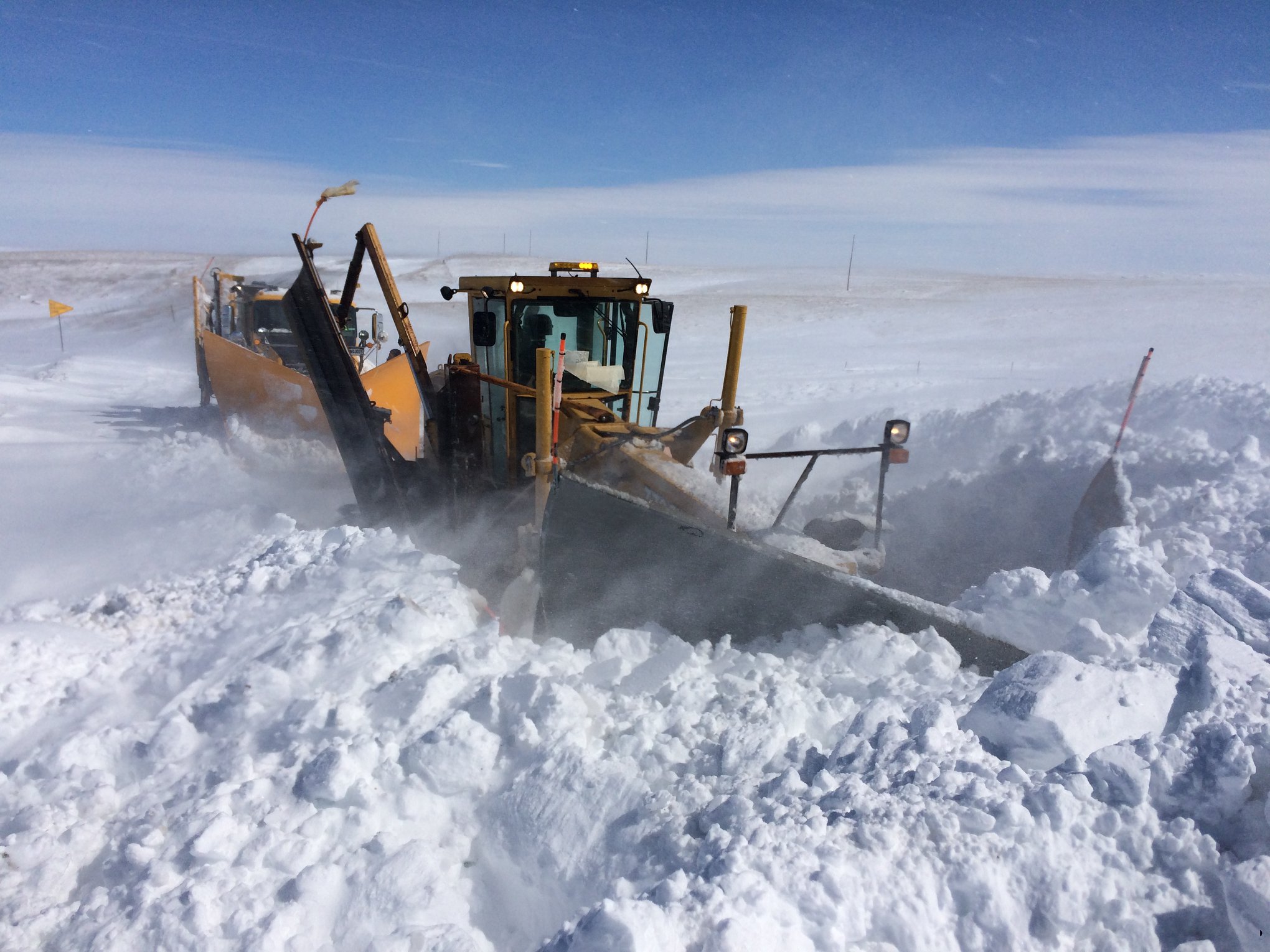
March 13-14th Blizzard: A historically deep low pressure system for Colorado tracked northeast and produced heavy rain and freezing rain mainly across eastern South Dakota, and heavy snow, widespread blizzard conditions and/or severe drifting of snow mainly across central South Dakota. Wind gusts of 50 to 70 mph occurred across all of the area. Numerous road closures and crippling, multi-day impacts resulted. More information can be found here: https://www.weather.gov/abr/ReviewMarch13-14Blizzard
Photo courtesy of the South Dakota Highway Patrol
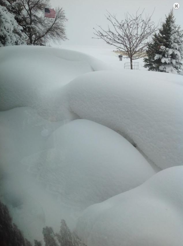
April 10-12th Heavy Snow: 3-12” of snow fell by the evening of the 10th, and another 6-18” fell mainly on the 11th along with 40-50 mph wind gusts. Some of the highest snowfall totals: 30.8” in Wallace, 28.9” in Clark (all-time record for 1, 2 and 3-day snowfall), 27.5” 19 miles NNW of Highmore, 26.3” in Clear Lake (all-time record for 3-day snowfall) and 25.0” in Watertown (all-time record for 2 and 3-day snowfall) and Ipswich (all-time record for 1, 2 and 3-day snowfall). More information can be found here: https://www.weather.gov/abr/April112019BlizzardSummary
Photo courtesy of Rose Hoellein in Northville, SD
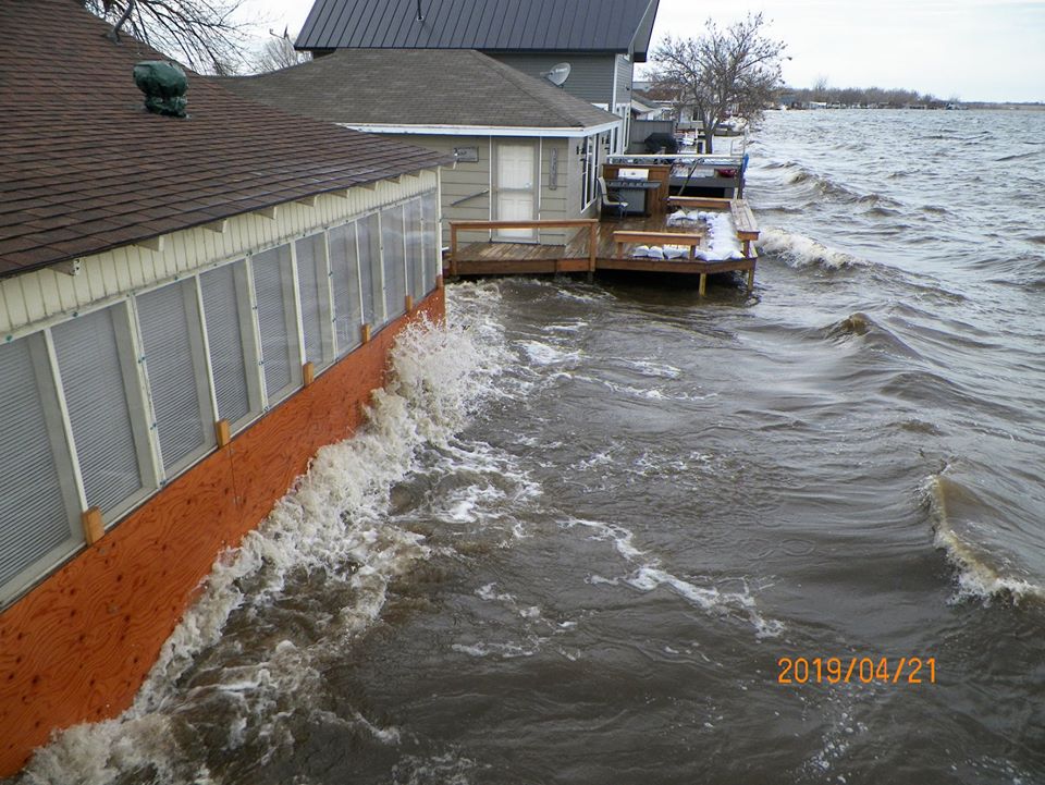
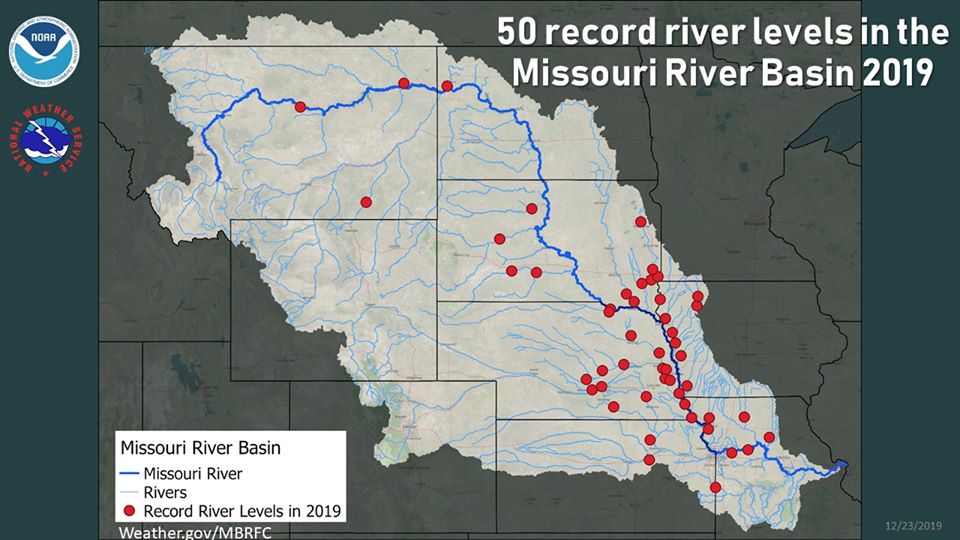
Spring 2019 Flooding: Significant snow depths across the area began melting during and after the March 13-14th system. Moderate, major and even historic flooding in some cases resulted across the Missouri, James, Big Sioux and other rivers/basins due to snowmelt and ice jams. Overland flooding occurred as well, since snowmelt was unable to soak into the initially still frozen ground. Flooding with significant impacts to a great number of roads and properties would continue into April, May and beyond as additional moisture, record-breaking in some cases, fell on top of already saturated soils and swollen streams and lakes.
Photo left courtesy of Victor Erlacher at Lake Poinsett on April 21st. Image right from the Missouri Basin River Forecast Center, showing the scope of the flooding. 50 of their 433 forecast points hit record levels in 2019, over a span of 6 months.
August 6th Hail Scar Storms: Severe thunderstorms with up to 3” diameter hail and 80 mph wind gusts pulverized portions of Central South Dakota. Two separate large hail scars were visible from satellite a few days after, which depicted the devastated crops. Two rounds of storms about an hour apart affected those roughly from Blunt to Lower Brule to Iona. These storms later went on to produce an EF-1 nighttime tornado in Burke (NWS Sioux Falls’ forecast area). More information can be found here: https://www.weather.gov/abr/20190806_LargeHail.
Photo courtesy of Beaty Hanson in the Whitlock Bay area

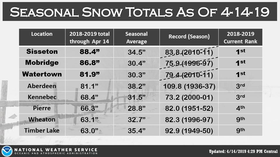
Record-Breaking Snow/Moisture: The 2018-2019 winter season went down as the snowiest on record at Sisseton, Mobridge and Watertown, and Aberdeen, Kennebec and Pierre all finished in the top 5 (see graphic below). As for total *annual* snow from January 1 to December 31st, 2019 ranks as the snowiest on record in Aberdeen (97.3" vs 95.6" in 1937), Pierre (83.1" vs 65.8" in 1985), Watertown (79.5" vs 65.9" in 2018) Mobridge (104.1" vs 69.4" in 1966), Sisseton (84.1" vs 72.2" in 2009), and Kennebec (80.8" vs 71.0" in 1918). Timber Lake finished 5th and Wheaton 6th. Regarding total 2019 moisture, Kennebec, Sisseton and Mobridge recorded their wettest year on record with 35.74”, 34.92” and 29.51”, breaking their records of 30.25” (1915), 32.30” (1993) and 26.86” (1915) respectively. Kennebec had already set their record by September 30th, and Sisseton and Mobridge by October 31st. Timber Lake, Watertown and Pierre all recorded their 2nd wettest calendar year on record while Wheaton and Aberdeen finished in the top 10.
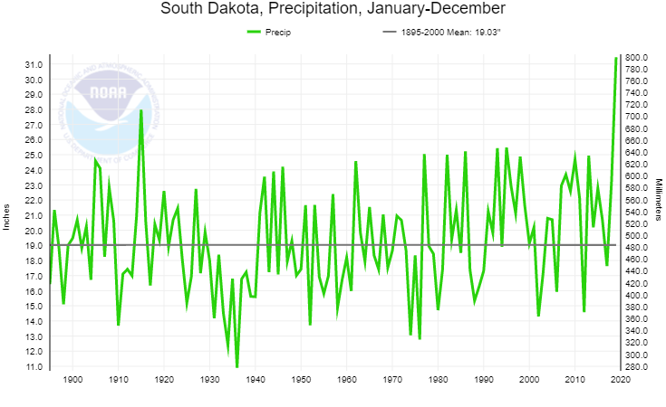
Precipitation data below/right is from https://www.ncdc.noaa.gov/cag/statewide/time-series and shows state-wide averaged precipitation amounts since 1895 (125 years’ worth of data). 2019, on the far right of the graph, ranks first with an average of 31.44” across the state. This is 12.41" above average, and breaks the previous record of 27.97" set in 1915.
Several other significant events in 2019 deserve an honorable mention:

