Overview
At the end of each year, NWS Aberdeen meteorologists reflect on the most stand-out events across our forecast area over the previous year. What was your top event of 2021? Feel free to share your opinion and even a story if you'd like of how weather impacted you this past year on our Facebook (search US National Weather Service Aberdeen South Dakota) and/or Twitter (@NWSAberdeen) pages. Have a happy New Year!
.
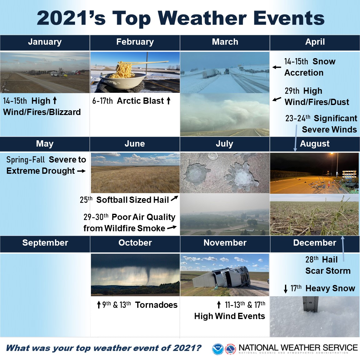
Calendar of 2021's Top Weather Events
The following events were voted on by NWS Aberdeen for top 5 consideration.

Top 5 Weather Events of 2021
Below are the top 5 weather and climate events of 2021 across central and northeastern SD and west central MN, in terms of scope, severity of impacts, and/or rarity. In chronological order:
February 6-17th Arctic Blast
The 2020-2021 meteorological winter (Dec-Feb) was very mild through the end of January (top 5 warmest for much of the area), which this took many off guard as there were several incidences of people falling through lake ice. However, winter came in full force in February, as a potent and persistent outbreak of Arctic air affected our region and beyond from February 6th through 17th. The magnitude of the cold during this outbreak is fairly rare when compared to other outbreaks over the past 50 years, at least in terms of the persistence of the Arctic air, and in some locations more closely resembled outbreaks from the late 1800s and the first half of the 1900s. This was especially impressive considering the lack of deep, fresh snow cover across the majority of the area, which allows for the development of much colder temperatures. Numerous impacts resulted, including frozen/broken water pipes and significant strains to the power grid. Nationally, this event registered as a billion dollar disaster. Much more information here

Photo taken on Sunday, February 14th in Aberdeen, courtesy of NWS employee
2021 Severe to Extreme Drought
2019 was an exceptionally wet year across the area, but 2020 was quite dry and 2021 followed suit. The US Drought Monitor highlighted portions of central SD in Severe/D2 Drought anomalously early in the year, by February 23rd, and this was a bad sign of things to come. Before June was through, the Governor of South Dakota had declared a statewide State of Emergency for drought conditions, and the USDA designated several counties as primary natural disaster areas. Meteorological summer (Jun-Aug) finished tied 4th hottest on record for the state of South Dakota and 20th driest, and the state of Minnesota finished 2nd hottest and 7th driest (record keeping began 126 years ago in 1895), and many locations this year recorded the most 90+ degree days on record since 1988. There were significant impacts. Agriculturally, conditions mimicked those of the 1988 drought. Cattle producers have been severely strained, and many were forced to sell their cattle. Entirely dry or very low stock ponds, creeks and marshes adversely impacted wildlife, and grasshoppers, midge flies and other pests impacted portions of Central and North Central SD. Very dry to completely cured fuels led to numerous fires, especially during and around the 4th of July, and several days of blowing/lofted dust were observed.
Photo taken on Tuesday, June 29th near Mobridge, courtesy of the Walworth County Emergency Manager
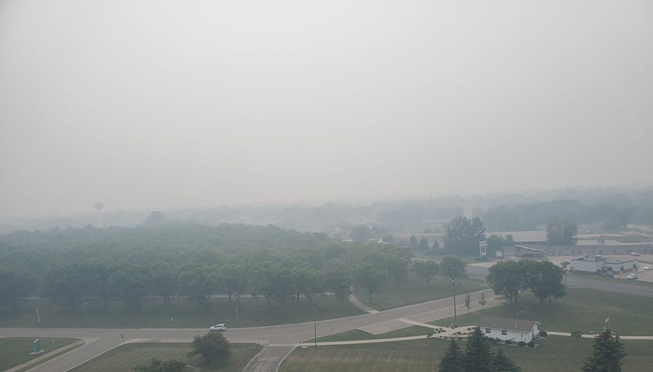
July 29-30th Poor Air Quality from Canadian Wildfire Smoke
It was a common occurrence this summer for smoke from Western US and Canadian wildfires to be transported aloft eastward and/or southward by upper-level winds, which lead to numerous milky afternoon skies and red sunrises and sunsets across the Northern Plains. But July 29th and 30th was different - a cold front swept smoke southward from several large Canadian fires across southeastern Manitoba and southwestern Ontario, and kept the smoke at the surface all the while. As a result, even 500+ miles away from the fires themselves, visibility was reduced to 1-2 miles or less and there was a strong smell of smoke with air quality categorized as unhealthy for all people spending time outdoors, as determined by the Air Quality Index. Air quality alerts were in affect for many as well.

Photo taken around 6pm on Thursday, July 29th in Milbank, courtesy of the Grant County Emergency Manager
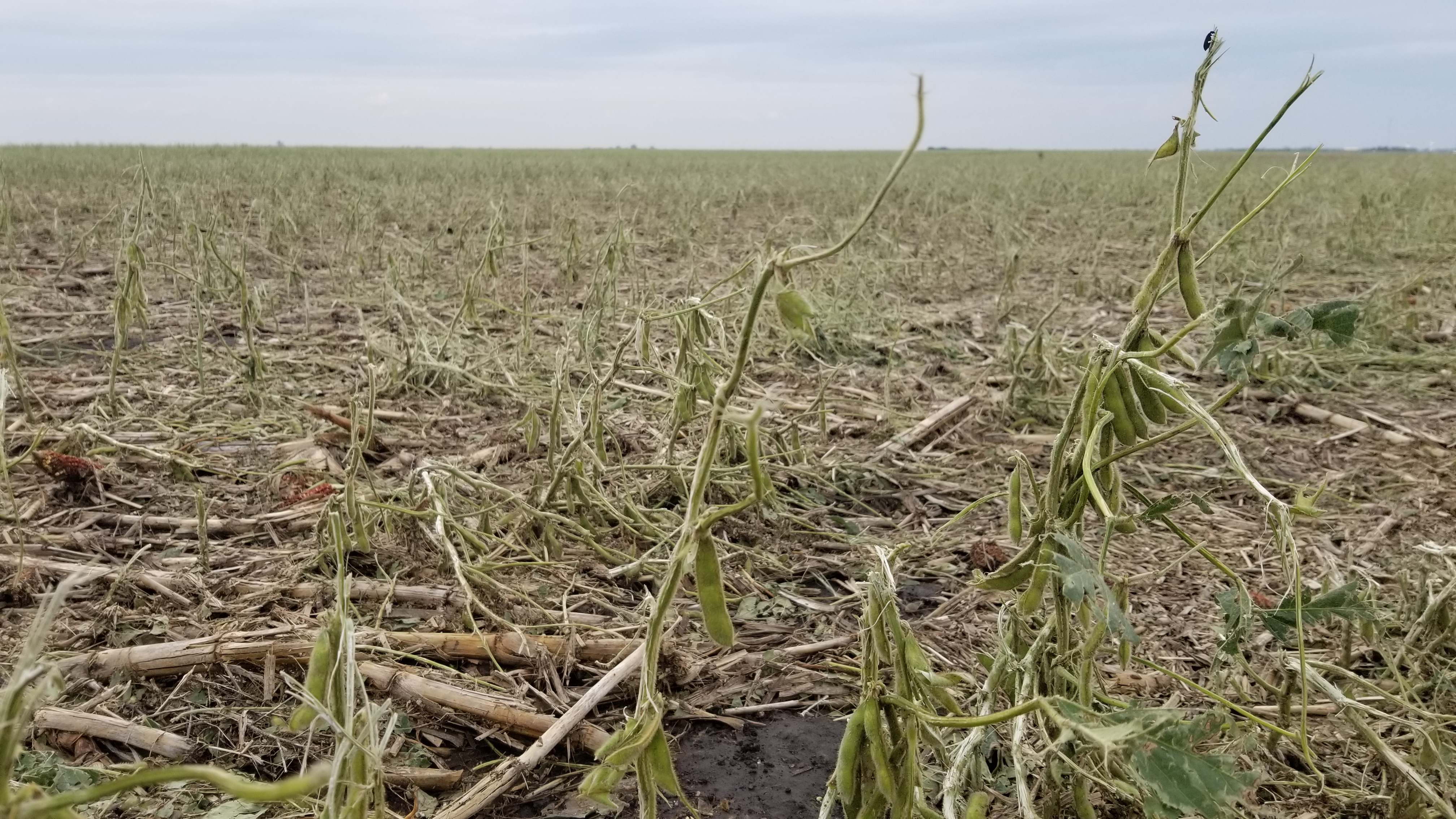
August 28th Hail Scar Storm
The 2021 severe season was unusually quiet thanks to the drought, until late August when several complexes of severe thunderstorms rolled across the forecast area. Several severe thunderstorms developed on the morning of the 28th, but a particularly intense and long-track supercell that began near Lake Oaha didn't stop producing hail of at least 1" in diameter for about 6 hours along an estimated 225 mile path generally just north of Hwy 12 into Big Stone County in west central MN. This storm produced significantly large hail of tennis ball and baseball or larger diameter, and led to extensive damage to houses, vehicles, crops, and anything else along its path. This included animals, as many deer and birds were reported killed. Damage was severe and complete enough for a scar to appear across the landscape on satellite imagery. Much more information here

Photo taken on Saturday, August 28th a couple miles south of Ipswich, courtesy of NWS employee
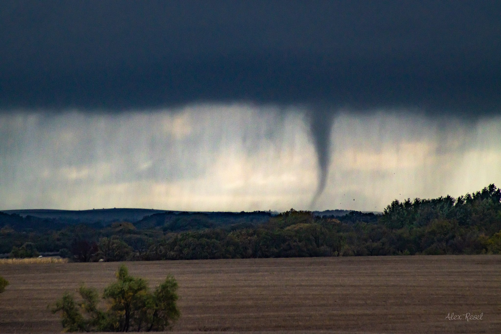
October 9th and 13th Tornadoes
Very late-season severe weather developed on two separate occasions in association with two similar low pressure systems from the afternoon into the evening across northeastern SD and west central MN. This included, on both occasions, several rare October tornadoes which were rated as EF0s and EF1s in strength (up to 112 mph winds) after damaging several farmsteads and properties. These were historic outbreaks for this time of year. Prior to 2021, there had been just 18 total October tornadoes confirmed in the state of South Dakota, and 29 in Minnesota. This October alone, 7 additional tornadoes have been confirmed in South Dakota and 9 in Minnesota, and this October ranks 2nd for both states in terms of the most tornadoes in October, behind only 1996. Much more information here

Photo taken around 3pm on Wednesday, October 13th near Goodwill, courtesy of Alex Resel
Highlights of the Honorable Mentions
January 14-15th High Wind/Fires/Blizzard: High wind gusts Thursday into Friday of 45-75 mph for 24+ consecutive hours were responsible for tipping numerous high-profile vehicles, localized blowing dust, spreading several fires from Pierre to Lemmon, and blizzard conditions across northeast SD and west central MN when a trace to 4" of snow mixed in. More information here
March 14-15th Snow Accretion: Persistent breezy to windy conditions combined with wet snow of 4-9” in near 32 F temperatures from Sunday into Monday to create snow accretion on power lines across south central SD. This caused a significant strain on wires and poles and, as a result, hundreds of people lost power.
March 29-30th High Wind/Fires/Blowing Dust: High temperatures on Monday in the 70s and 80s and low relative humidities combined with high wind gusts of 40 to 60 mph to produce large, wind-driven fires across portions of central SD, the largest of which (in our forecast area) burned around 10,000 acres in central Jones County. High wind gusts of 50 to 70+ mph continued through the night and into Tuesday, and apparent temperatures dropped ~70 degrees by the morning. Blowing dust led to very poor visibility at times as well.
July 25th up to Softball Sized Hail: A number of severe thunderstorms produced large to significantly large hail as they tracked to the east and southeast across the area in 90 to 100 F temperatures on Sunday. One of the more prolific supercell thunderstorms produced hail continuously for 3+ hours over ~125 miles from Faulk to Codington Counites, producing up to nearly 4" diameter hail along the way. More information here
August 23-24th Significant Severe Winds: A complex of storms developed on Monday night across north central SD and then tracked east through Tuesday morning. A wind gust of 112 mph was recorded 11 miles south of Bullhead, and a 91 mph gust was recorded 7 miles north of Frederick. Farm outbuildings sustained significant damage.
November 11-13th and 17th High Wind Events: 50 to 80 mph wind gusts were recorded across the area from multiple systems, leading to numerous high-profile vehicle accidents, blizzard conditions across portions of the Prairie Coteau, and very high fire danger across central SD at times.
December 17th Banded Heavy Snow: A relatively small band of heavy snow developed Friday morning across portions of northeastern SD and west central MN and persisted through the evening, resulting in over a foot of snow. Hardest hit was Marshall County.
 |
Media use of NWS Web News Stories is encouraged! Please acknowledge the NWS as the source of any news information accessed from this site. |
 |