
A heat wave over the Southwest will intensify this week, peaking and expanding into the Intermountain West and northern High Plains this weekend. Critical to extremely critical fire weather conditions are forecast from the Northwest and the northern Great Basin this weekend. Particularly Dangerous Situation Red Flag Warnings have been issued. Read More >
Weather History - November 9th
Local and Regional Events:
November 9th, 1977:
An intense early winter storm moved northeast from Colorado to Iowa on November 9th and then to Lake Superior by November 10th. In most areas, the precipitation began late on the 8th as rain with temperatures in the 50s, changing to snow early on Wednesday the 9th, with the storm continuing through Thursday. In west-central Minnesota, some freezing rain also occurred before it changed to all snow. As the storm intensified, the winds in the eastern half of South Dakota increased with some gusts as high as 60-70 miles per hour, with widespread visibilities reduced to zero in blowing snow. In west-central Minnesota, north to northwest winds of 60 to 80 mph reduced visibility to zero and piled snow into eight-foot drifts. The temperature dropped rapidly into the 20s. Many roads throughout the eastern part of South Dakota and west-central Minnesota were blocked, and the heavy wet snow immobilized snow plows. Many cars and trucks were snowbound on the roads and highways. Approximately 100 cars and trucks were stalled on Interstate 90, east of Murdo. Near Fergus Falls in western Minnesota, two trucks loaded with turkeys became stuck, and half the birds were frozen. Many schools were closed on the 9th and 10th. Snowfall amounts in the eastern half of the state were more significant than four inches. A band of heavy snow, ten inches or more, extended from Bridgewater to Howard to Clear Lake into parts of west-central Minnesota. The high winds also destroyed a 1400-foot TV tower at Garden City. In addition, there was some loss of the corn crop. Sunflowers comprised the greatest loss because they had not been entirely harvested. Reports of livestock losses were minimal. Some storm total snowfall amounts include; 15 inches in Watertown; 14 inches in Sisseton; 12 inches in Clear Lake and Wheaton; 10.5 inches in Castlewood; and 9 inches near Raymond and Bryant.
U.S.A and Global Events for November 9th:
1864: On Election Night, a violent tornado strikes a ferry on the Mississippi River near Chester, Illinois, blowing away all but the hull. The boiler and engines are found up the bluff. Half of Chester was destroyed, and twenty died during the storm.
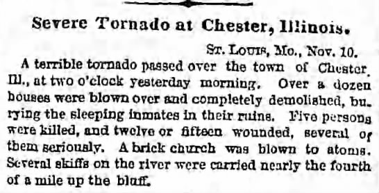
The image above is from The Brooklyn Daily Eagle Brooklyn, New York
November 11th, 1864, Fri • Page 3.
1926: An estimated F3 to F4 tornado tore through La Plata, Maryland, killing 14 individuals at a small school. This storm caused 17 deaths and injured 65 others. Click HERE for more information from the Monthly Weather Review.
Click HERE for more This Day in Weather History from the Southeast Regional Climate Center.

