Wildfire smoke will push into the Midwest, worsening air quality. A frontal system brings severe storms from the Northern Plains to the Mid‑Atlantic the next few days. Heavy Gulf Coast rain is possible as Tropical Depression Two has formed, while monsoonal storms persist in the Southwest with heavy rainfall. Hazardous heat expands from the Plains into the Lower Mississippi Valley. Read More >
Weather History - November 7th
Local and Regional Events:
November 7th, 1986:
A major winter storm dumped 10 to 25 inches of snow over most of North Dakota. The snow combined with winds of 30 to 50 mph and gusts to 70 mph, creating blizzard conditions. Snow began over southern and eastern North Dakota on the morning of the 7th, and by late afternoon, had spread over the entire state. The snowfall was heavy at times and continued through the night of the 7th. In the southeast quarter, the snow alternated with rain, freezing rain, and sleet. By daybreak on the 8th, snow and blowing snow was occurring statewide. By late morning, the storm had intensified into a blizzard over almost all of North Dakota. The blizzard ended over extreme western North Dakota by late afternoon of the 8th and over the rest of the state that night. The most substantial snowfall occurred over south-central and east-central North Dakota. The highest wind gusts of the storm happened in the north-central and northeast sections of the state. Several wind gusts to 58 mph were recorded at Grand Forks, and a gust to 55 mph occurred at the Minot Air Force Base. Wind chills dipped to 40 below over some parts of the state. The storm happened on the opening day of deer hunting season and forced many hunters to cancel their trips.
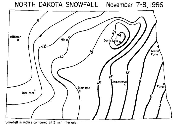
The image above is courtesy of Storm Data.
November 7th, 2000:
A storm system brought 4 to 10 inches of snow and northwest winds of 30 to 50 mph, with higher gusts to create blizzard conditions to South Dakota. Numerous schools and other events were canceled due to the blizzard conditions. In addition, several accidents occurred due to the slick roads and low visibilities. Some storm total snowfall amounts include; 9.5 inches in Selby; 8 inches in Glenham and 12SSW of Harrold; 7.3 inches near Onaka; 7 inches at Faulkton; and 6 inches in Miller.
U.S.A and Global Events for November 7th:
1940: The Tacoma Narrows Bridge opened on July 1st, 1940, spanned the Puget Sound from Gig Harbor to Tacoma. At the time of the opening, the bridge was the third-longest suspension bridge in the world, covering nearly 6,000 feet. Before the bridge opened, high winds would cause the bridge to move vertically, giving the nickname Galloping Gertie. On this day in 1940, winds of 40 mph caused the bridge to collapse because of the physical phenomenon known as aeroelastic flutter. Click HERE for more information from Scott Sistak from KOMONews. Click HERE for a YouTube video.
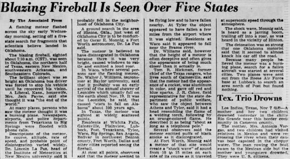
1951: At 7 AM, a blinding flash, a massive ball of fire, and a terrific roar occurred over parts of Texas, Oklahoma, and Kansas, caused by a disintegrating meteor. Windows were broken in and near Hinton, Oklahoma, by the concussion.
1957: A historic tornado outbreak impacted southeast Texas and southwestern Louisiana. Ten people were killed.
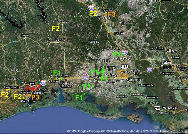
The image above is courtesy of the NWS Office in Lake Charles, Louisiana.
2001: Typhoon Lingling struck the southern Philippines, killing 171 people with 118 missing in Camiguin. The typhoon then struck Vietnam 5 days later, killing an additional 18 people.

2011: A powerful storm system moving through the southern Great Plains produced tornadoes, large hail, damaging winds, and flooding across parts of Oklahoma and western north Texas on November 7-8, 2011. The system initially produced numerous thunderstorms, heavy rainfall, and flash flooding over portions of south-central Oklahoma during the late evening of November 6th and early morning of November 7th. Rainfall totals of 5-9 inches were reported across Jefferson, Carter, and Murray counties. Click HERE for more information from the NWS Office in Norman, Oklahoma.
2012: A Nor’Easter brought several inches of snow to the Northeast. Snowfall amounts of 2 to 6 inches were typical with locally higher amounts.
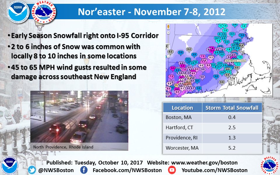
The image above is from a tweet by the NWS Office in Boston.
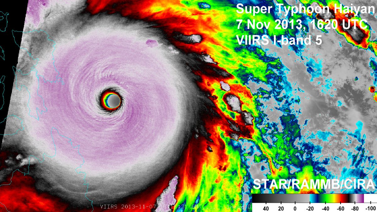
2013: Super Typhoon Haiyan made history as one of the largest and strongest typhoons ever recorded. Click HERE for more information from NOAA.
Click HERE for more This Day in Weather History from the Southeast Regional Climate Center.