
Widespread life-threatening flash and urban flooding continues in south-central Texas, with considerable flooding impacts possible across central Texas. Wildfire smoke is impacting air quality across much of the Great Lakes region into southern New England and the Mid-Atlantic. Monsoonal thunderstorms may produce isolated to scattered flash flooding across the Southwest into the Great Basin. Read More >
Weather History - January 17th
Local and Regional Events:
January 17, 1996:
Two to as much as fifteen inches of snow, high winds from 40 to 60 mph, and cold arctic air resulted in blizzard conditions and extreme wind chills from 40 below to 70 below from the mid-morning of the 17th to the early evening of the 18th. Most schools, federal, state, and county offices were closed. Various activities are also canceled. Travel was challenging due to the near-zero visibility, with some vehicles stranded. Highway 12 from Webster to the Minnesota border and Interstate-29 closed on the 18th. Hundreds of people were stranded, with some people stranded in their vehicles. Some pheasants and wildlife were lost due to the snow-packed so hard they could not dig out. Some snowfall amounts include; 2 inches at Highmore, 3 inches at Pierre and 9NE Reliance, 5 inches at Mobridge, Presho, Roscoe, 10SE Stephan, and Ree Heights, 6 inches at Tulare, 7 inches 12W Tulare and 5E 3S Faulkton, 8 inches 11E 2S Hosmer and at Doland, 9 inches at Mellette, Aberdeen, and Redfield, and 10 inches at Eureka and Britton, and 12 inches at Wilmot, Rosholt, and Ortonville, Minnesota. Fifteen inches occurred at Wheaton, Clinton, and Graceville. The extreme wind chills and some blowing snow continued across central and north-central South Dakota into the early evening of the 18th.
January 17, 2012:
Below are some very rare lake effect waterspouts. Chris Westcott took these pictures in the vicinity of Lower Brule. The waterspouts form from the instability created when the air associated with the Missouri River’s relatively warm open waters interacts with the frigid air located just above the surface. These types of waterspouts have a very short lifespan and dissipate just as quickly as they form. Chris saw six of them at one time.
U.S.A and Global Events for January 17th:
1490: On the night of January 17 through the 18th, a “certain fine rain, which froze whilst it fell, and make icicles upon trees” occurred in Florence, Italy. “There was such a quantity of it that the weight bowed the trees down to the ground and broke the branches.” The above is from “A Florentine Diary from 1450 to 1516” by Landucci, Luca. Click HERE to read the book.
1837: The green flash was first documented by Captain Back of the H. M. S. Terror while in the Arctic during 1836-1837. He wrote: “In the morning, however, at a quarter before ten o'clock while standing on an ice hummock about 17 feet high, and looking toward the east, I had observed the upper limb of the sun, as it filled a triangular cleft on the ridge of the headland, of the most brilliant emerald color, a phenomenon which I had not witnessed before in these regions.” Click HERE for more information about green flashes from EarthSky.org.
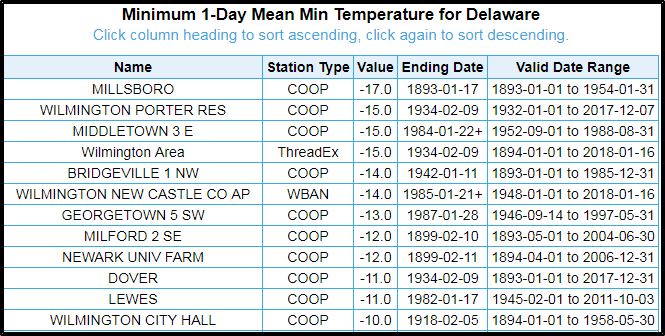
1893: Delaware's coldest temperature of -17 F occurred on January 17th, 1893, in Millsboro.
1916: Reno, Nevada, received 22.5 inches of snow, its greatest 1-day snowfall total ever. Click HERE for more information from the Reno Gazette-Journal.
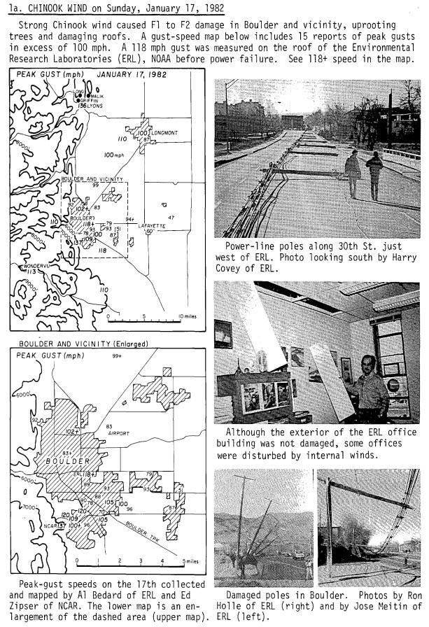
1982: Strong chinook winds caused severe wind damage in Boulder, Colorado. A wind gust of 118 mph was recorded on the roof of the Environmental Research Laboratories (ERL), and a wind gust of 137 mph was measured atop the roof of the NCAR building (in the southwest part of the city, 600 feet above ground level). The high winds uprooted trees and damaged roofs.
1994: On January 17, 1994, at 4:31 a.m. PST, a magnitude 6​.7 earthquake centered in Northridge struck the southern California area. Known as the Northridge Earthquake, it caused at least 57 fatalities (a subsequent study put the death toll at 72, including heart attacks) and injured thousands. Click HERE for more information from the California Department of Conservation.
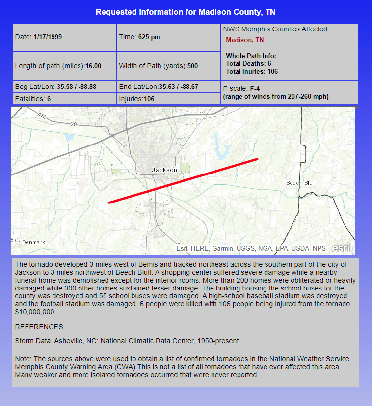
1999: An F4 tornado tracked across southern Jacksonville, Tennessee, damaging more than 200 homes and 55 buses. The storm killed six people and injured 106.
2016: A potent storm system developed and tracked quickly eastward across the Gulf of America and toward Florida on Saturday, January 16, 2016. The impacts from this storm reached west-central and southwest Florida during the early morning hours of Sunday, January 17, 2016. A squall line of strong to severe thunderstorms, just ahead of the cold front, produced periodic wind damage and isolated tornadoes as it quickly moved ashore across west-central and southwest Florida and pushed across the state. Two EF2 tornadoes touched down, one near Siesta Key in Sarasota County and the other near Duette in Manatee County. Two adults were killed and four others injured when their mobile home rolled over and was destroyed by the tornado in Manatee County. Click HERE for more information from the NWS Office in Tampa Bay, Florida.
Click HERE for more This Day in Weather History from the Southeast Regional Climate Center.

