Weather History - January 16th
Local and Regional Events:
January 16, 1967:
In Minnesota, a fast-moving blizzard brought winds over 75 mph. The snowfall was light to moderate, with extensive blowing and drifting snow. Visibility was near zero for an extended time. Temperatures fell rapidly during the storm, and by the morning of the 18th, many record lows temperatures were set. Many vehicles went into the ditch. Thousands of motorists and schoolchildren found shelter wherever they could as travel was halted. A Wheaton man froze to death. In South Dakota, rain followed by a sudden drop in temperatures of nearly 30 degrees in 2 hours resulted in widespread freezing rain and significant icing on roads and trees. Strong winds of 35 to 45 mph with gusts to 75 mph along with the ice halted most travel. The wind and icing also caused the toppling of a 270-foot radio tower near Aberdeen.
January 16, 1997:
An intense Arctic High brought widespread blizzard conditions and dangerous wind chills of 40 to 70 below to central and northeast South Dakota and west-central Minnesota. One to 3 inches of snow fell on top of the already deep snowpack of 2 to 5 feet. The blizzard winds brought another round of widespread heavy drifting, blocking area roads and highways. Many area schools were closed once again to add to their large number of days missed for the winter season. Fortunately, this blizzard was short-lived compared to previous blizzards, and the people were better prepared.
January 16, 2014:
A strong area of high-pressure building into the region behind an Arctic cold front brought high winds to central and north-central South Dakota during the early morning hours of the 16th. Some of the strongest wind gusts include; 69 mph near Whitlocks Bay; 68 mph near Bullhead; 67 mph near Trail City; 66 mph in Foster Bay; 65 mph near Mellette and in Presho; 64 mph near Harrold and in Murdo; and 63 mph in Pierre, Reliance, and Miranda. The strong winds diminished during the late afternoon hours of the 16th. A clipper system passing across the region brought light snowfall and powerful northwest winds gusting more than 70 mph at times resulting in blizzard conditions. The highest wind gusts include; 76 mph at the Brown County Landfill, 69 mph in Aberdeen and Cravens Corner, 52 mph near Webster, and 52 mph in Sisseton. Blizzard conditions ended during the late afternoon hours. A no travel advisory was issued in Grant, Codington, Hamlin, and Spink Counties due to low visibilities. The blizzard led to the cancellation of several area activities and schools and nearly impossible travel conditions.
U.S.A and Global Events for January 16th:
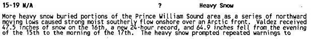
1990: Heavy snow fell across Prince Williams Sound and the Susitna Valley of southern Alaska. Valdez was buried under 64.9 inches of snow in less than two days, including a record of 47.5 inches in 24 hours. The heavy snow blocked roads, closed schools, and sunk six vessels in the Valdez harbor under the heavy snow’s weight. The image below is from Storm Data.
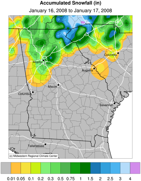
2008: An area of low pressure brought snow, sleet, and freezing rain across northern Georgia. Three to four inches was a typical amount reported from many of the northeast Georgia counties. Click HERE for more information from the NWS Office in Atlanta, Georgia.
Click HERE for more This Day in Weather History from the Southeast Regional Climate Center.

