Weather History - January 15th
Local and Regional Events:
January 15, 1982:
Snowfall amounts of one to four inches and powerful northwest winds of 35 to 45 mph with gusts to 60 mph caused blizzard conditions with widespread drifting across much of South Dakota and Minnesota from the early morning of the 15th to mid-afternoon on the 16th. Wind chills were lowered to 50 to 80 degrees below zero, and visibilities were near zero across most areas. One death was attributed to exposure. There were numerous weather-related accidents. Some of the major accidents included; a truck blown off Interstate 90 near Murdo, injuring the driver, a truck blown off Highway 281, turned upside down in a ditch, and a truck slamming into a bridge on Interstate 90 near Murdo. The extreme cold killed numerous fruit trees at a nursery in Watertown.
January 15, 1985:
Heavy snow fell in central and south-central South Dakota from the early evening of the 15th to around noon on the 16th, with areas around Pierre receiving up to 18 inches. Generally, 5 to 10 inches fell with numerous minor traffic accidents reported. Interstate 90 had a no travel advisory in a 95-mile stretch from Kimball to Murdo until the afternoon of the 16th due to low visibility and heavy drifting. Also, many schools and businesses were closed. Some snowfall amounts included 4 inches at Kennebec, 6 inches at Murdo, and 10 inches at Pierre.
January 15, 2009:
An Arctic high pressure settled in on the morning of the 15th, bringing the region’s coldest temperatures in many years. The combination of a fresh and deep snowpack, clear skies, and light winds allowed temperatures to fall to record levels at many locations on the 15th. Daytime highs remained well below zero across the area. This was one of the coldest days that most areas experienced since the early 1970s. The records were broken by 1 to as much as 7 degrees. Click HERE for a list of records.
U.S.A and Global Events for January 15th:
1852: In 1852, the long, cold winter froze the Susquehanna River in Maryland to a depth of 2 to 3 feet, preventing all ferry service. Railroad officials overcame this perplexing situation by laying tracks across the ice, with trestles for either bank’s inclines. During the several weeks from January 15 to February 29, approximately 1,300 cars with a total weight of 10,000 tons were hauled across the river from Havre de Grace, Maryland, to Perryville, Maryland.
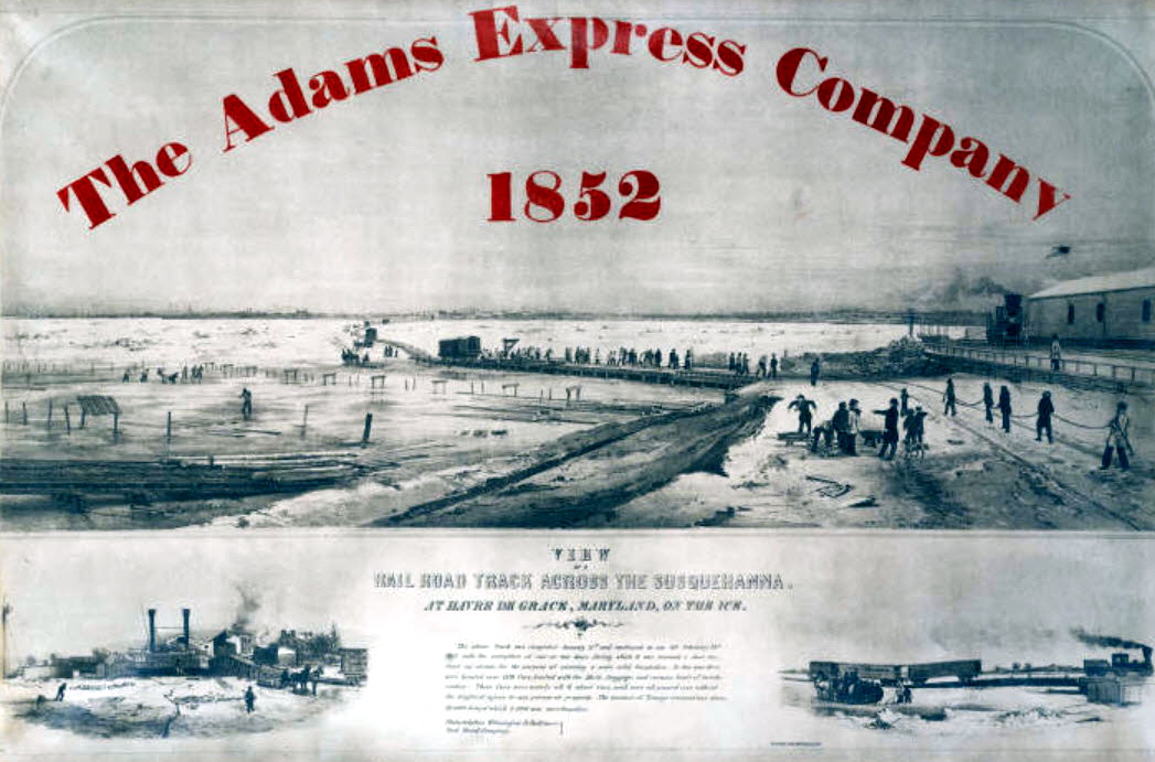
Railroad tracks on ice across the Susquehanna at Havre de Grace. Image Courtesy from Enoch Pratt Free Library.
1967: The Green Bay Packers beat the Kansas City Chiefs, 35-10, in Super Bowl I at the Memorial Coliseum in Los Angeles. From the weather station at the USC campus in downtown LA, the high temperature was 79 degrees, and the low was 51. There was a light west wind.
1972: In Flint, Michigan, the daytime temperature rose to only -3 degrees. This is the second coldest maximum temperature recorded in the city of Flint since 1921. Detroit's high temperature was zero.
Click HERE for more This Day in Weather History from the Southeast Regional Climate Center.

