
A significant heat wave is underway for the Intermountain West, Northern Plains, and Upper Great Lakes, peaking in intensity through midweek and lingering across parts of the Northern Plains and Midwest until this weekend. In southwest Texas, excessive rainfall may bring a risk for potentially life-threatening flash and arroyo flooding through Thursday. Read More >
Weather History - January 1st
Local and Regional Events:
January 1, 1960:
The winter storm began on New Year's Eve as a low-pressure center moved from Colorado northeast to the Great Lakes. Snowfall ranged from 5 to 10 inches across central and northeast South Dakota. High winds on the 1st and 2nd caused low visibilities and drifted highways over affecting holiday travel. There were scattered power and telephone outages due to breakage from wind and ice. The storm winded down in the afternoon of the 2nd.

The information above is from the Climatological Data Publications for South Dakota in January 1960.
U.S.A and Global Events for January 1st:
1767: The morning temperature in Boston was -8°F! 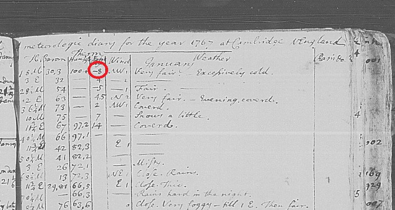
The image above is from a tweet by Brian Brettschneider.
1864: A historic cold blast of air charged southeast from the Northern Plains to Ohio Valley. Chicago had a high temperature of -16°. A farmer near Huntertown, Indiana, reported the same high temperature as Chicago, with a low of 21 degrees below zero. He remarked "rough day" in his weather diary. Minneapolis had a temperature of 25 degrees below zero at 2 PM. St. Louis, Missouri, saw an overnight low of 24 degrees below zero. The Mississippi was frozen solid with people able to cross it.
1886: Norway’s coldest night on record occurred as the low temperature dropped to -60.5ºF at Karasjok. Meteorologisk Institutt.
1888: The Signal Corps office opened in Rapid City, South Dakota, on January 1, 1888. It was located in the Sweeney Building at the corner of 7th and Main Streets. The high and low temperature that day was 6 and -17°F.

The image above is from a tweet by the NWS Office in Rapid City, South Dakota.
1892: At Pittsburgh, Pennsylvania, dandelions were in bloom in parks.

The image above is from a tweet by the NWS Office in Pittsburgh, Pennsylvania.
1935: The Associated Press Wire Photo Service made its debut, delivering the great weather maps twice each day to newspapers across the country. The first photo transmitted was a plane crash in the Adirondack of New York on this day. The plane crashed during the evening hours on December 28, but the rescue did not occur until New Year's Day. Click HERE for more information from the New York History Blog.

1961: A three-day-long ice storm was beginning over northern Idaho, which produced an accumulation of ice eight inches thick, a U.S. record. Dense fog, which blanketed much of northern Idaho from Grangeville to the Canadian border, deposited the ice on power and phone lines, causing widespread power outages. Click HERE for more information from the website winterstormsofamerica.weebly.com.
1964: A snowstorm struck the Deep South on December 31st, 1963, through January 1st, 1964. Meridian MS received 15 inches of snow, 10.5 inches blanketed Bay St Louis MS, and 4.5 inches fell at New Orleans, LA. The University of Alabama Head Football Coach “Bear” Bryant said that the only thing that could have messed up his team’s chances in the Sugar Bowl against Ole Miss in New Orleans, LA was a freak snowstorm. Well, much to his chagrin, 4.5 inches of snow fell the night before the big game. Alabama won the game 12-7 anyway. Freezing temperatures then prevailed for New Year’s Day. NWS Nashville and NWS Huntsville.
1999: The start of 1999 was ushered in with snow, ice, and freezing weather across central and south-central Nebraska. On New Year's Day, a steady snowfall along and north of Interstate 80 dumped from 1 to 5 inches of snow. By late morning, freezing drizzle developed southeast of Hastings and eventually coated area roads with a layer of ice. Light snow later that evening made travel even more treacherous. Several accidents occurred on the Interstates and Highway 30. Once the ice and snow ended, arctic air spilled across the area abroad 20 to 30 mph north winds. Blowing and drifting of the fallen snow caused reduced visibilities for a time on the 2nd. Temperatures dropped to 5 to 15 below zero through midday the 3rd.
2011: Southern and central Mississippi saw 11 tornadoes during the night of December 31st into the morning hours of January 1st. Of the 11, two were EF-3 with two more EF-2. Six were EF-1 with one EF-0. Click HERE for more information from the NWS Office in Jackson, Mississippi.

Click HERE for more This Day in Weather History from the Southeast Regional Climate Center.

