Weather History - February 25
Local and Regional Events:
February 25, 1987:
Six to thirty inches of snow fell on this date in 1987 across much of western and central South Dakota. Three to six inches of snow fell in the northeast part of South Dakota. Some of the most significant snowfall amounts reported were 30 inches at Phillip, 26 inches at Murdo, and Timber Lake, with 15 inches at Rapid City. Numerous accidents occurred in the western and central sections of the state. Many roads were closed, including Interstate 90, for most of the 27th. Slippery roads were a significant factor in the vehicle injuries of three women on Highway 12, six and one-half miles east of Ipswich, in the late afternoon of the 27th. The storm began on the 24th and lasted until the 28th.
February 25-March 1, 1998:
An incredible amount of snow falls on Lead, South Dakota, from February 25 through March 01, 1998. The official storm total was 114 inches for the five days. Click HERE for more information from the National Weather Service Office in Rapid City, South Dakota.
February 25, 2000:
Unusual February severe thunderstorms produced nickel to quarter size hail in Lyman and Hand counties on this date in 2000.
U.S.A. and Global Events for February 25:
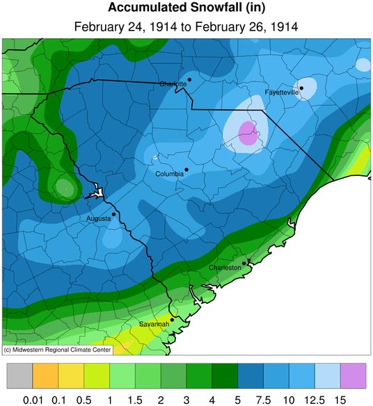
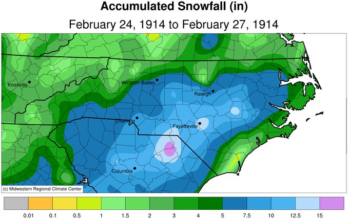
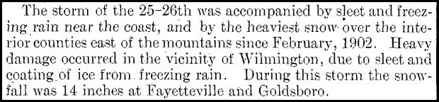
1914: Heavy snow fell over a good portion of South Carolina and North Carolina on February 24-26, 1914. Snowfall amounts include 18 inches near Society Hill, SC, 14 inches in Fayetteville, NC, 13 inches at Darlington, SC, 11.7 inches at Columbia, SC, 8.1 inches at Charlotte, SC, and 7.2 inches at Greensboro, NC, and 7.0 inches at Raleigh, NC.
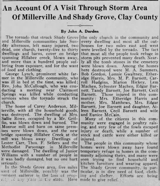
1934: An outbreak of six tornadoes killed nineteen in Mississippi, Alabama, and Georgia. The hardest-hit areas were Bowden, GA, and Shady Grove, AL. An estimated F4 tornado damaged or destroyed 90 homes, many in the Shady Grove community. One home in Lauderdale County, Mississippi, was picked up, thrown 400 feet, and blown to bits. Six family members were killed in the house. Three deaths occurred in two homes, and one preacher was killed during services. Click HERE for more information about the tornadoes in Lauderdale County, Mississippi.
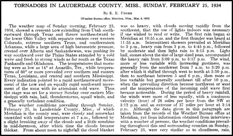
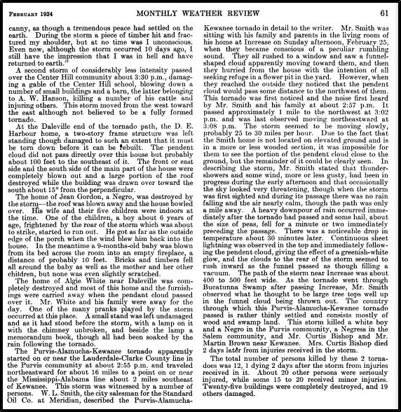
The images above are from the Monthly Weather Review for February 1934.
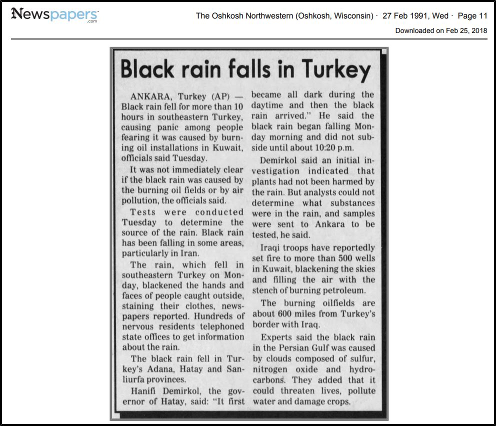
1991: Black rain fell over southeastern Turkey for 10-hours, causing panic among people. The black rain resulted from soot from burning oil fields in Kuwait.
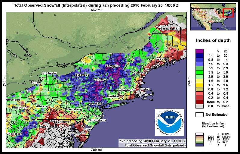
2010: A powerful nor'easter spread significant snow and windy conditions across the Middle Atlantic region from Thursday, February 25 into Friday, February 26. An area of low pressure developed off the Carolina coast late Wednesday night, February 24, and then strengthened as it tracked northward to near Long Island, New York, by Thursday evening. As low pressure aloft deepened over the Mid-Atlantic coast Thursday night into Friday, the surface low retrograded and moved westward into northern New Jersey and southern New York. By February 27, the low pushed into southern New England and gradually weakened over the weekend. Strong wind gusts were measured throughout the Middle Atlantic region due to this coastal storm. Some of the highest wind gusts recorded include 62 mph measured at Cape May, New Jersey; 52 mph at the Atlantic City Marina; 51 mph at the Mount Pocono Airport and Lewes, Delaware; and 50 mph at Dover Air Force Base. In addition, wind gusts of 40 mph or higher were recorded in Philadelphia, Wilmington, and Allentown. Considerable blowing and drifting snow resulted, especially from the Poconos eastward into northern New Jersey. Snow drifts as high as 3 to 5 feet were seen across portions of Warren and Sussex counties in New Jersey. Total accumulations of 20 inches or more were recorded from Morris and Sussex counties in New Jersey, westward into Monroe County, Pennsylvania. In addition, a band of 12 to 18 inches of snow accumulation was measured from Warren and Morris counties in New Jersey westward to Lehigh County, Pennsylvania. In addition to snow that accumulated during the daytime on Thursday, many locations across the region experienced a heavier burst of snow with gusty winds Thursday night into early Friday, thanks to additional moisture wrapped around the low-pressure system. Some areas saw snowfall rates of 1 to 2 inches per hour, mainly from northern New Jersey and into the Poconos. Central Park ended the month with 36.9 inches of snow, making this the snowiest month since records began in 1869.


2017: An EF1 tornado was confirmed in Goshen and Conway County, MA. This tornado was the first-ever recorded in February for M.A. since records began. The graphic below is from a tweet by the N.W.S. Office in Boston, MA.

Click HERE for more This Day in Weather History from the Southeast Regional Climate Center.

