Weather History - February 1st
Local and Regional Events:
February 1, 1969:
Across central and eastern South Dakota, February 1969 contained a variety of winter weather causing many difficulties. Glazing due to dense fog and drizzle periodically formed on utility lines creating numerous broken power lines. Strong winds caused widespread blowing and drifting snow resulting in many closed roads. Snowplows would open the streets, and often drifting snow would close the roads again. Frequent uses of pusher-type snowplows piled banks of snow 20 to 30 feet along the roads, and it became impractical to open routes with this type of snowplow. Several rotary snowplows were flown in from military airbases outside the state to open some of the roads in the eastern part of the state. Many school closings occurred during the month due to snow blocked roads.
February 1, 1989:
Four to eight inches of snow fell across western and northern South Dakota. Winds of 25 mph and subzero temperature produced wind chills in the 50 to 80 below zero range. Several schools were closed across the area due to the dangerous wind chills. The storm continued into the 2nd.
U.S.A and Global Events for February 1st:
1916: Seattle, Washington, was buried under 21.5 inches of snow, their most significant 24-hour snowfall. A total of 32.5 inches of wet snow accumulated over three days. The Seattle cathedral dome collapsed under the snow's weight. Click HERE for more information from Scott Sistek at KOMONews. Click HERE for a YouTube video.
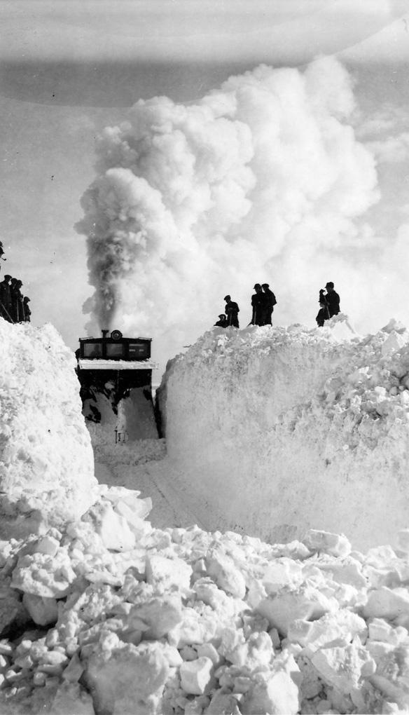
1947: January 30th through February 8th, a great blizzard occurred in Saskatchewan, Canada. All highways into Regina were blocked. Railway officials declared the worst conditions in Canadian rail history. One train was buried in a snowdrift over a half-mile long and 36.7 feet deep. Click HERE for more information from Environment and Climate Change, Canada.

The photo above is of a C.N.R. train buried by a snowstorm of February 9, 1947, near Weyburn, and effort to dig it out. SK Archives Photo R-A9033-8.
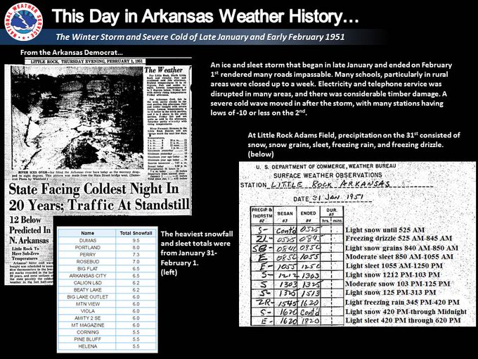
1951: An ice and sleet storm began in late January and ended on February 1st rendered many roads impassable. Electricity and telephone service was disrupted. The graphic below is from a tweet by the NWS Office in Little Rock, Arkansas.

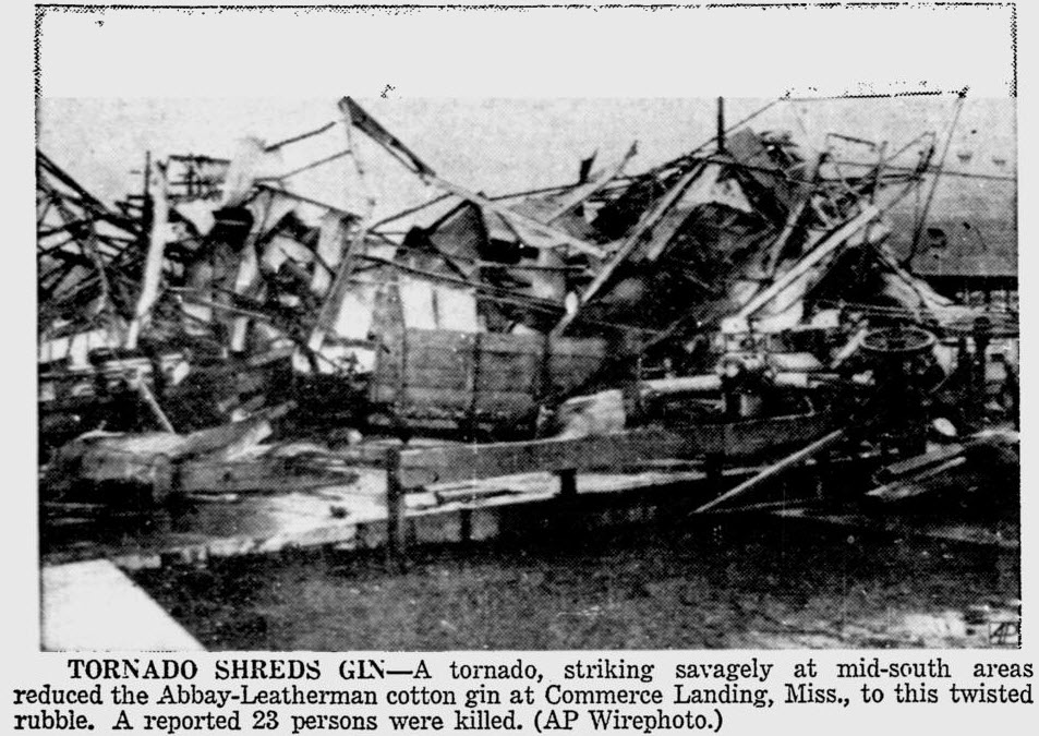
1955: Seen first as a "well-defined cone-shaped funnel" over the Mississippi River, this F3 tornado cut a path from Commerce Landing to Clark in northeastern Mississippi. This tornado killed 20 and injured at least 141 individuals. Most of the deaths were in a plantation school. The following is from Thomas Grazulis, "Significant Tornadoes 1680-1991" book: "Despite the fact that a funnel was seen, that heavy objects were thrown long distances, and that the tornado was in a forecast box, the event was not officially called a tornado. A survey team state that since all debris was thrown in one direction, the event should not be listed as a tornado." Click HERE to read more about this event from the Monthly Weather Review.

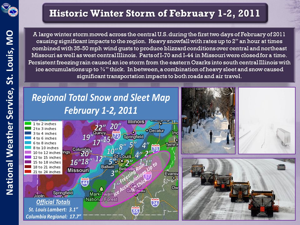
2011: One of the most significant events of the 2010-2011 winter season affected a widespread region from Texas to the Midwest and Northeast from February 1st to 3rd 2011. The system produced widespread heavy snow with blizzard conditions and significant freezing rain and sleet to other locations. Snowfall amounts of 10 to 20 inches were common from northeast Oklahoma to lower Michigan. The storm produced 20.2 inches at Chicago, the third heaviest snowfall in the city since their records began in 1886, along with a peak wind of 61 mph. Kansas City received just under 9 inches of snow. The high temp was 17 degrees. Click HERE for more information from the Weather Prediction Center.

The graphic above is from a tweet by the NWS Office in St. Louis, Missouri.
Click HERE for more This Day in Weather History from the Southeast Regional Climate Center.