Weather History - December 23rd
Local and Regional Events:
December 23, 1987:
Five to sixteen inches of snow fell in 24 hours in east-central and southeast South Dakota from the morning of the 23rd through the morning of the 24th. Some of the more significant amounts measured were 9 inches at Huron, 10 inches at Mitchell, Platte and Brookings, twelve inches at Chamberlain, and sixteen inches at Alpena. Heavy snow also fell in southwestern Minnesota, with Big Stone and Traverse Counties in the west-central portion of the state missing out on the heaviest snow. Considerable blowing and drifting snow hampered removal, particularly in South Dakota, due to reduced visibilities. Snowfall amounts also included three inches at Castlewood, five inches at Clear Lake, and six inches at Bryant.
December 23, 1996:
Blizzard conditions developed across northeast South Dakota and west-central Minnesota in the late afternoon of the 23rd and continued into the late evening. Visibilities were frequently below one-quarter of a mile. Two to six inches of new snowfall combined with the already significant snow cover and north winds of 20 to 40 mph to cause widespread blizzard conditions and heavy drifting on area roads. Travel was significantly impacted if not impossible, and one fatality resulted from a head-on collision. Some snowfall amounts in Minnesota included 5 inches at Artichoke Lake and 6 inches at Wheaton and Browns Valley. In South Dakota, 7 inches fell at Britton, Webster, and Clear Lake, with 6 inches at Sisseton and 5 inches at Summit.
U.S.A and Global Events for December 23rd:
1921: An estimated F3 tornado struck the town of Clarkedale, Arkansas, killing six and injuring 60 others. Four people died in the destruction of the Banks and Danner store, where 50 people were doing their Christmas shopping.
1924: A storm producing winds of 70 mph caused extensive damage to Sydney, Australia during the evening hours.
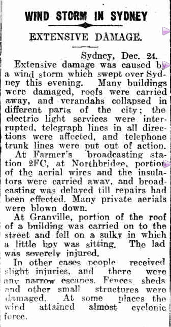
The article above is from the Kalgoorlie Miner newspaper.
1998: A major ice storm struck central and southeast Virginia and much of North Carolina beginning on Wednesday, December 23, and lasting until Christmas Day morning. Icy conditions caused injuries from slips and falls and numerous vehicle accidents. Ice accumulations of up to an inch brought down trees and power lines. Outages were so widespread with 400,000 customers were without power on Christmas Eve. Some people were without power for up to ten days. Click HERE for more information from the State Climate Office of North Carolina.
Click HERE for more This Day in Weather History from the Southeast Regional Climate Center.

