Weather History - December 19th
Local and Regional Events:
December 19, 1968:
Snow and near-blizzard conditions existed across west-central Minnesota, with 5 to 7 inches of new snow reported. Heavier snowfall amounts were reported further to the southeast in Minnesota. Six inches of snow was reported in Artichoke Lake in Big Stone County.
December 19, 1990:
Snow began to fall over the northwest part of Minnesota by early afternoon on the 19th, and fell heavily during the night into the early afternoon of the 20th, spreading over the entire northern 2/3 of the state and into some of northeastern South Dakota overnight. By mid-morning, a swath of snow of 6 inches or more was deposited over much of the northern half of the state, or north of a line from Elbow Lake to Garrison to near Two Harbors. In west-central Minnesota, Wheaton received 6 inches, Browns Valley received 4 inches, and Artichoke Lake received 3 inches. In South Dakota, Webster reported 8 inches, Britton reported 7 inches, Sisseton reported 5 inches, and Aberdeen reported 4 inches.
U.S.A and Global Events for December 19th:
1777: George Washington led his hungry and weary from long marches men to Valley Forge on this day. The winds greeted the 12,000 Continentals as they prepared for the winter. Click HERE for more information from the History Channel. Click HERE for more information from the website, History Things.com.
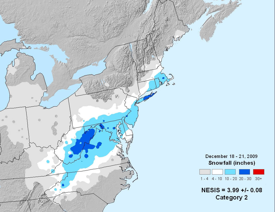
2009: Snowfall totals from 1 to 2 feet were commonplace in what will go down as one of the biggest snowstorms in history on the East Coast and the first of four snowstorms for the Mid-Atlantic during the winter of 2009-10. The 15 inches of snow measured at Reagan International Airport on Dec. 19th was the third-highest daily snowfall on any calendar day at Washington, DC, since snowfall records began in 1884. The total storm snowfall of 16.4 inches on Dec 18-19 2009 marks the 6th highest two-day snowfall record for Washington, DC putting it just below the second President's Day storm in 2003 and ahead of the Jan 1996 storm. Baltimore Washington Airport saw 20.5 inches of snow and went down as the fifth-highest daily snowfall on any calendar day in Baltimore since snowfall records began in 1893. The total storm snowfall of 21.0 inches on Dec 18-19 2009 marks the 6th highest two-day snowfall record for Baltimore. The daily snowfall records for Dec 19 were smashed for the most snowfall for any calendar day during December at the following stations. Reagan National Airport's new record was 15.0 inches, old record 11.5 in 1932. Baltimore Washington Airport's new record was 20.5 inches, old record 11.5 in 1932. This was the biggest December snowstorm on record and setting a record for the snowiest December for Baltimore, MD. Dulles Airport's new record was 16.0 inches, old record 10.6 in 1982. Richmond International Airport had a total of 6.4 inches. Philadelphia, Pennsylvania, reported its second greatest daily snowfall total on record with 22.9 inches. It also was the single most significant December snowfall for the city of Philadelphia, PA. Roanoke, Virginia, recorded 17.8 inches setting a record for the greatest 24-hour snowfall in December. Washington, DC, reported 16.4 inches of snowmaking 2009 the snowiest December on record, all in one storm. In New York, Upton on Long Island recorded 26.3 inches, the biggest snowstorm on record.

Satellite image of the North American blizzard of 2009 on December 20. Image courtesy of NASA.

Storm total snowfall. Image courtesy of NOAA.
​
Click HERE for more This Day in Weather History from the Southeast Regional Climate Center.