Weather History - August 23rd
Local and Regional Events:
August 23, 1960:
Lightning and damaging winds caused damage to occur from Hand and Sanborn Counties to Marshall and Roberts Counties. A small airplane was destroyed, and the high winds broke windows in Miller. Also, roofs, TV antenna, utility lines, and trees were damaged in Kingsbury and Marshall Counties.
August 23, 1998:
Winds gusting to 65 mph in and around Milbank, in Grant County, took the roof off a mobile home and wrapped it around a utility pole. The people inside the mobile home were uninjured. The Summit Dairy Barn had sustained significant damage. The high winds also blew a shed and a large tennis court fence down. Several trees along with many large tree branches were down all over town. Strong winds were also reported in Day and Roberts Counties. Winds of 60 mph also downed many tree branches north of Watertown.
U.S.A and Global Events for August 23rd:
1724: An event is known as the "Great Gust of 1724" occurred on this day. Almost all tobacco and much of the corn crops were destroyed by this violent tropical storm, which struck the Chesapeake Bay. Intense floods of rain and a huge gust of wind were seen on the James River. Some homes were wrecked, and several vessels were driven ashore. The storm was likely followed by a second hurricane just five days later causing rain for many straight days that caused the Virginia floods of 1724.
1933: A hurricane made landfall near Nags Head, North Carolina and tracked up the Chesapeake Bay. The Chesapeake-Potomac hurricane moved over Norfolk, Virginia, and Washington, DC. A seven-foot tide flooded businesses in Norfolk, Virginia. Described in the American Meteorological Society's August 1933 weather review as "one of the most severe storms that have ever visited the Middle Atlantic Coast." Click HERE for vintage photos provided by The Washington Post.
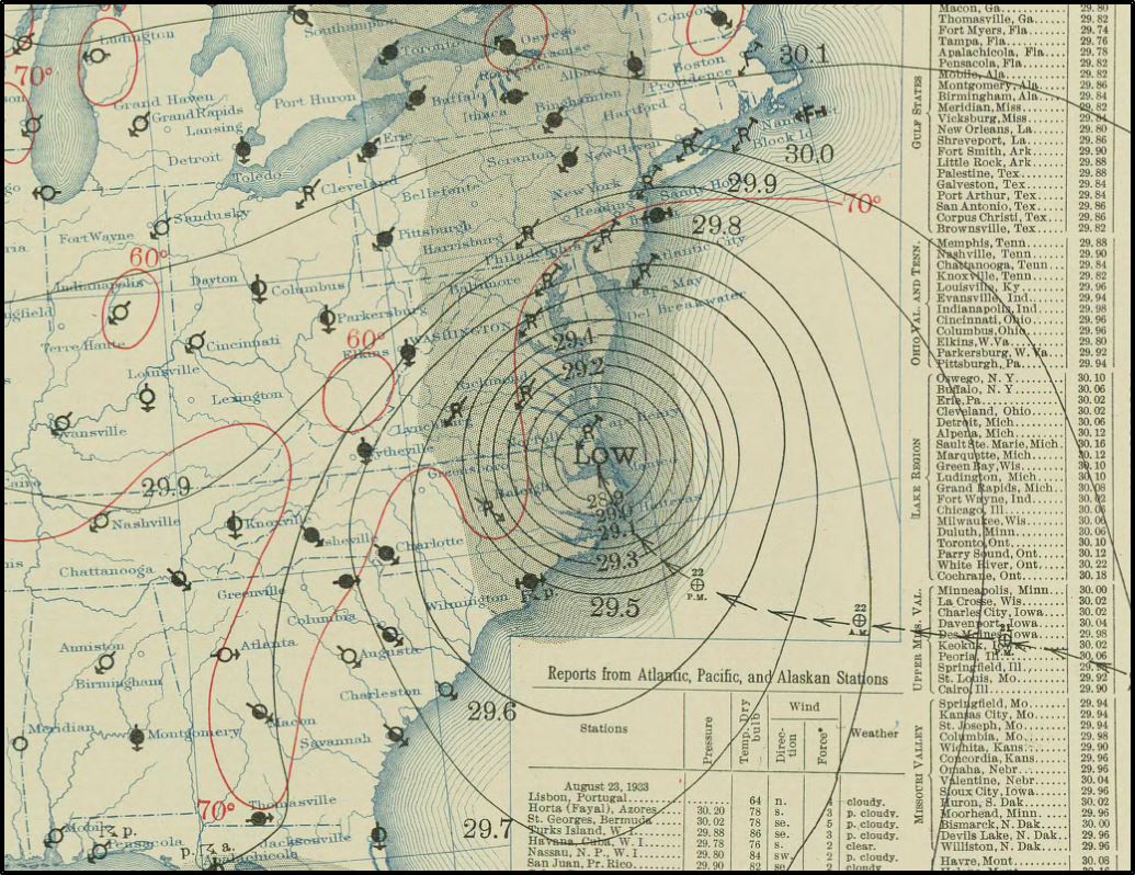
Above is the surface map for August 23rd, 1933 at 8 AM, EST.
1992: While South Florida residents were preparing for Hurricane Andrew, folks in western Montana were dealing with early season snowfall. Some snowfall amounts include 8.3” in Great Falls, 6.2” in Helena, and 5.1” in Cut Bank. This snowfall is the first significant snowfall on record in western Montana in August.
2005: Hurricane Katrina formed from Tropical Depression Twelve over the southeastern Bahamas. Katrina would become the costliest ($81.2 billion) and one of the most deadly hurricanes (1,836 lives) in U.S. history.
Click HERE for more This Day in Weather History from the Southeast Regional Climate Center.

