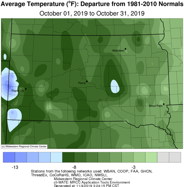
Temperatures this October were below average by anywhere from 3 degrees around the MN/SD border to 9 degrees across portions of central SD. A strong low pressure area ushered in multiple days of well-below freezing air in the middle of the month which ended the growing season. Record cold high temperatures were recorded on the 11th at Watertown (33° vs 35° in 2009), Aberdeen (35° vs 37° in 1959) and Pierre (34° vs 36° in 2009), and again on the 12th at Sisseton (36° vs 36° in 1959) and Aberdeen (34° vs 35° in 1959).
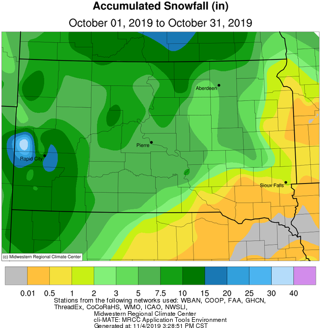
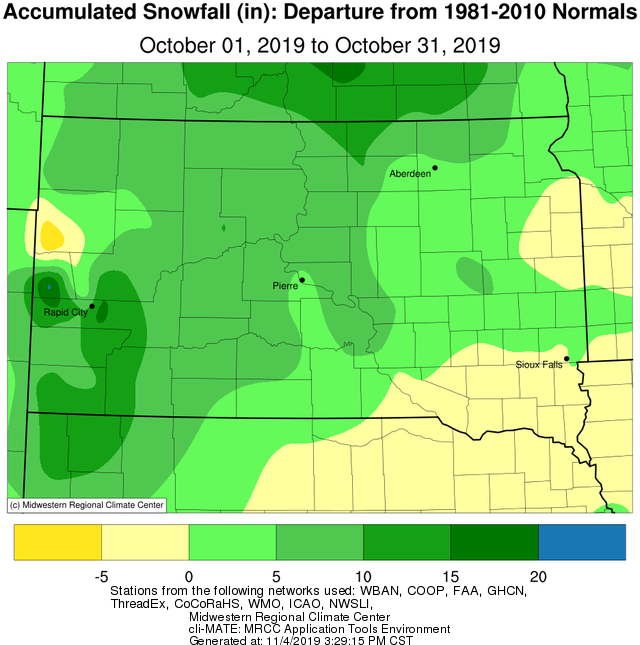
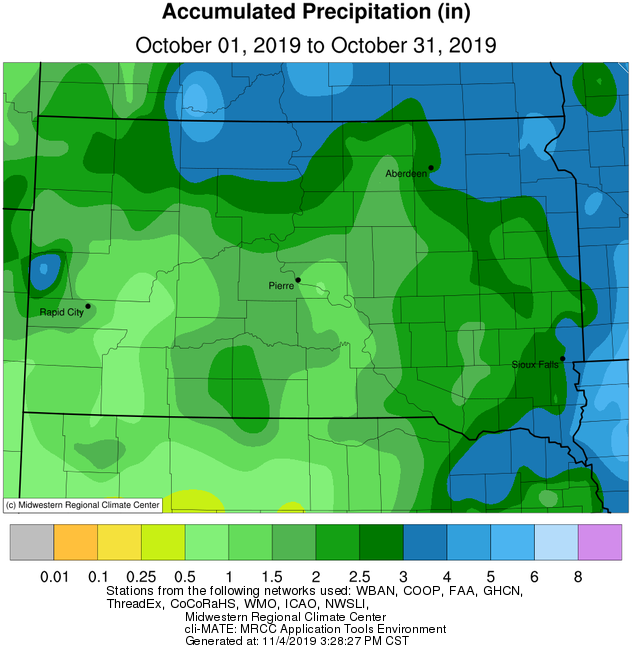
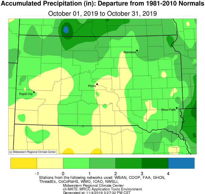
Precipitation totals finished above average across portions of northeastern and north central SD and west central MN, while central SD was near normal. Snowfall was above average for all but east central SD. Two main storm systems impacted the area. The first, a climatologically early snowstorm from the 10-12th, was significant across portions of north central South Dakota and especially further north into North Dakota. Record daily snowfalls of anywhere from 0.7” to 4.3” fell at Aberdeen, Watertown, Sisseton, Mobridge, and/or Pierre on the 10th, 11th and/or 12th. More on this event can be found here: https://www.weather.gov/abr/October10-12WinterStorm. The second main system of note this October, a rainstorm on the 20-21st, dumped generally 1-2” of rain across portions of northeastern and north central SD and west central MN. Daily rainfall records were set on the 20th at Mobridge (1.08” vs 0.94” in 1963) and on the 21st at Watertown (0.69” vs 0.52” in 1952), Sisseton (1.88” vs 0.53” in 1931) and Mobridge (0.93” vs 0.32” in 2008).
An interesting note… remember the late spring snows? With just 180 days (between April 12th and October 10th), Aberdeen tied their 4th shortest period on record between the season’s last and first 1” snowfalls (170 days in 1990 and 1970). Similarly, Watertown had 181 days (between April 12th and October 11th) which tied their 6th shortest stretch (164 days in 1979), Pierre had 181 days (between April 11th and October 10th) which was their 3rd shortest stretch (176 days in 1970), Mobridge had 180 days (between April 12th and October 10th) which was their tied 5th shortest stretch (170 days in 1990), Wheaton had 182 days (between April 12th and October 12th) which was their 3rd shortest stretch (177 days in 2002), and Timber Lake had just 161 days (between May 1st and October 10th) which ranks as their 2nd shortest stretch (147 days in 1950). This comes on the heels of another short period between between 1” snows at some of these locations in 2018 when mid-April and mid-October snows fell as well.
As noted before, October finished above average for many. Here are updated rankings for total year-to-date precipitation through October 31st: Aberdeen: 27.82” ranks 10th, Wheaton: 29.84” ranks 7th, Watertown: 31.75” ranks 2nd (36.27” in 1977), Timber Lake: 28.44” ranks 2nd (33.45” in 1915), Pierre: 28.87” ranks 3rd (31.51” in 1997), Mobridge: 27.51” ranks 1st (26.73” in 1915), Sisseton: 33.49” ranks 1st (31.27” in 1901), Kennebec: 33.41” ranks 1st (29.16” in 1915).
Here are updated rankings of total yearly precipitation through October 31st (every additional hundredth of precipitation from now through the remaining 61 days of the calendar year will only add to these rankings/records): Aberdeen: 27.82” ranks 16th, Wheaton: 29.84” ranks 12th, Timber Lake: 28.44” ranks 5th (34.10” in 1915), Pierre: 28.87” ranks 3rd (31.85” in 1997), Watertown: 31.75” ranks 2nd (40.04” in 1977), Mobridge: 27.51” ranks 1st (26.86” in 1915), Sisseton: 33.49” ranks 1st (32.30 in 1993), Kennebec: 33.41” ranks 1st (30.25” in 1915).
|
October 2019 |
||||
|
Temperature Data |
Aberdeen |
Sisseton |
Wheaton |
Watertown |
|
Warmest Temperature / Date |
70°/ 7, 8th |
71°/ 8th |
72°/ 9th |
68°/ 8th |
|
Coldest Temperature / Date |
11°/ 31st |
15°/ 31st |
17°/ 31st |
15°/ 31st |
|
Average High / Departure from Normal |
50.4°/ -7.2° |
49.1°/ -8.1° |
50.9°/ -6.0° |
48.5°/ -7.9° |
|
Average Low / Departure from Normal |
30.9°/ -1.8° |
33.4°/ -2.1° |
34.7°/ +0.2° |
32.6°/ -1.9° |
|
Monthly Average / Departure from Normal |
40.7°/ -4.5° |
41.2°/ -5.1° |
42.8°/ -2.9° |
45.5°/ -5.0° |
|
Precipitation Data |
||||
|
Monthly Precipitation / Departure from Normal |
2.66”/ +0.67” |
3.61”/+1.53” |
3.40”/ +1.23” |
2.33”/+0.41” |
|
Most Precipitation in 24 hours / Date |
1.17”/ 10th |
1.88”/ 21st |
0.94”/ 22nd |
0.71”/ 10th |
|
Monthly Snowfall / Departure from Normal |
5.0” / +4.3 |
1.2” / +0.5 |
1.0 / +0.3 |
1.5 / -0.2 |
|
Most Snow in 24 hours / Date |
2.7” / 10th |
0.7” / 11th |
1.0 / 12th |
1.3 / 11th |
|
Temperature Data |
Pierre |
Kennebec |
Mobridge |
Timber Lake |
|
Warmest Temperature / Date |
76°/ 8th |
80°/ 8th |
74°/ 8th |
77°/ 8th |
|
Coldest Temperature / Date |
14°/ 31st |
10°/ 30th |
12°/ 31st |
11°/ 31st |
|
Average High / Departure from Normal |
52.1°/ -8.9° |
55.0°/ -8.8° |
51.8°/ -8.0° |
48.5°/ -11° |
|
Average Low / Departure from Normal |
31.5°/ -4.9° |
30.6°/ -5.4° |
31.2°/ -3.4° |
28.9°/ -6.1° |
|
Monthly Average / Departure from Normal |
41.8°/ -6.9° |
42.8°/ -7.1° |
41.5°/ -5.7° |
38.7°/ -8.6° |
|
Precipitation Data |
||||
|
Monthly Precipitation / Departure from Normal |
1.45”/ -0.20” |
1.54”/ 0.0” |
3.56”/ +1.86” |
3.10”/ +1.54” |
|
Most Precipitation in 24 hours / Date |
0.39”/ 10th |
0.38”/ 10th |
1.08”/ 20th |
1.14”/ 12th |
|
Monthly Snowfall / Departure from Normal |
5.3 / +4.3 |
6.7 / +5.9 |
5.6 / +5.0 |
8.4 / +7.3 |
|
Most Snow in 24 hours / Date |
4.3 / 10th |
3.0 / 10th |
3.6 / 10th |
3.6 / 11th |
Temperature departures (average of highs and lows) this October, courtesy of the Midwestern Regional Climate Center
Precipitation totals (left) and departures (right) this October, courtesy of the Midwestern Regional Climate Center
Snowfall totals (left) and departures (right) this October, courtesy of the Midwestern Regional Climate Center