Overview
|
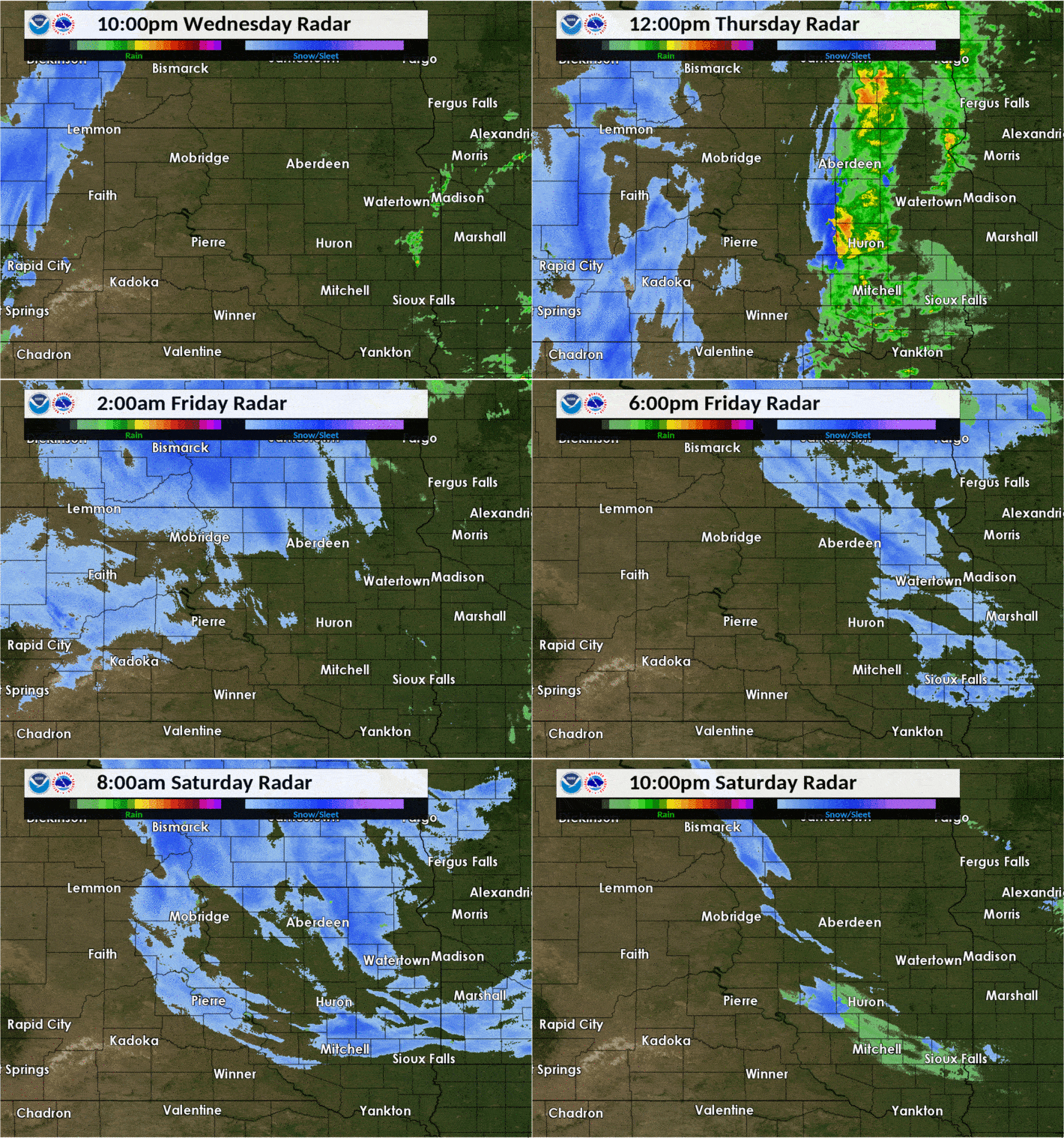
A strong low pressure system tracked northeast across the Northern Plains before stalling in Northern Minnesota from October 10-12th. With an abundance of moisture and enough cold air in place, a historic, early-season winter storm resulted. While starting as rain in most instances on the 10th, cold air shifted from west to east and most areas switched over to sleet and then snow by the overnight from the 10th into the 11th. Thundersnow was reported in Herried and other locations during this storm. Along with the snow which totaled up to a foot in north central South Dakota, northwest winds gusted generally between 40 and 50 mph particularly on Friday the 11th. This put an added strain on snow-covered and leaf-laden trees. Additionally, low temperatures tanked into the 20s for multiple nights, which ended the growing season. Wind chills were even colder, in the single digits. Road conditions through the course of the event deteriorated greatly and several vehicles slid into ditches. Agriculture and ranchers were also adversely affected, by the snow in the short term and by the additional moisture in the longer term. Due to the still relatively high sun angle, snow melted completely within a couple days after the storm in South Dakota, but took longer to do so in the hardest-hit areas of North Dakota. |
 Pressure and winds from Thursday Oct 10th through Saturday Oct 12th |
Photos & Video
 |
 |
 |
 |
| SDDOT images during the morning of the 10th | SDDOT image from the Forest City Bridge at 9am on the 10th | SDDOT image from 2 miles north of Herreid at 9am on the 12th | SDDOT image from 13 miles east of Eureka at 9am on the 12th |
 |
 |
 |
 |
| SDDOT image from 4 miles west of Lowry at 9am on the 12th | SDDOT image from 5 miles west northwest of McLaughlin at 9am on the 12th | SDDOT image from Ridgeview at 9am on the 12th | SDDOT image from 4 miles west of Trail City at 9am on the 12th |
 |
 |
 |
 |
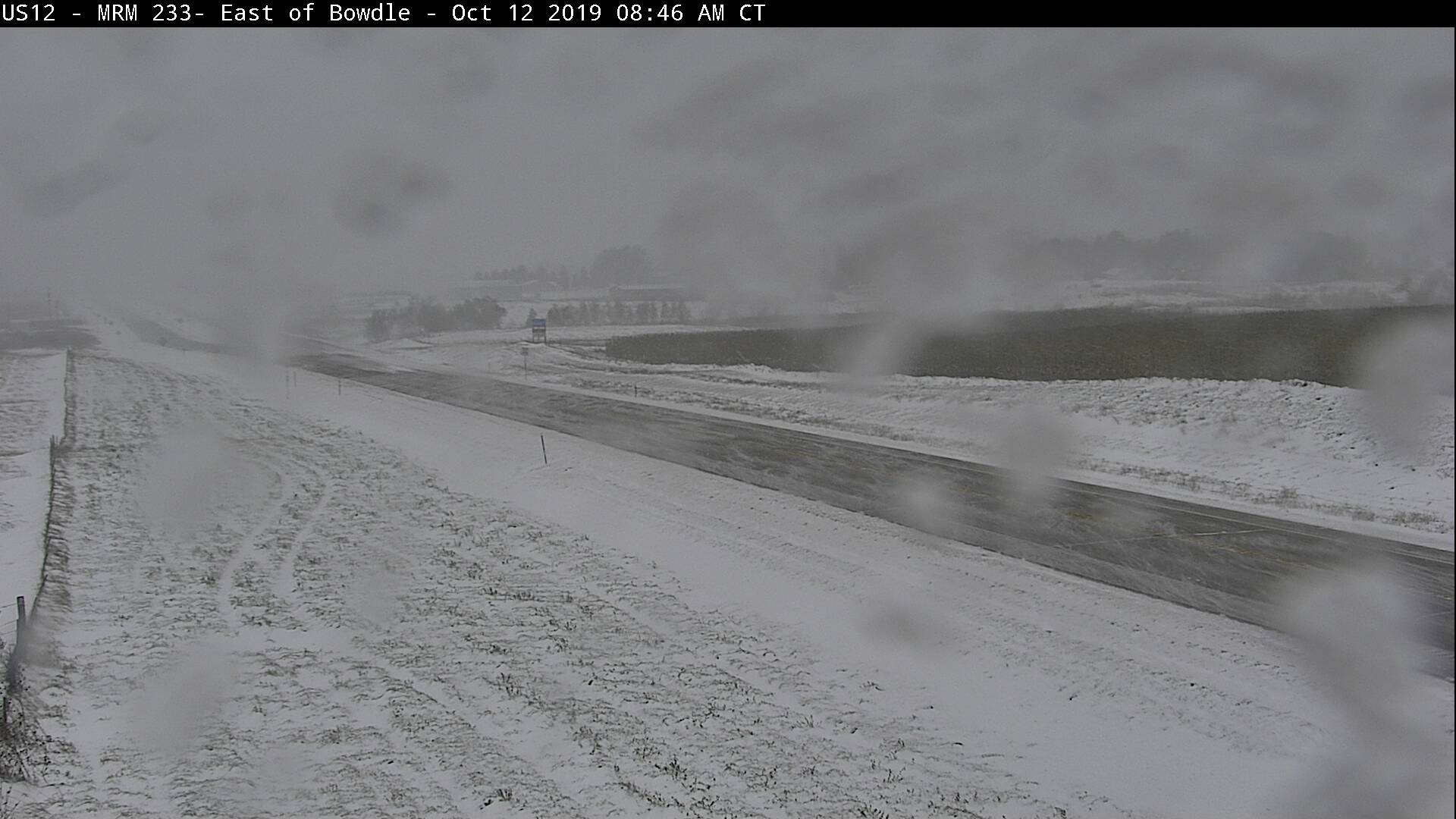
| SDDOT image from 4 miles west of Waubay at 9am on the 12th | SDDOT image from Bowdle at 9am on the 12th | SDDOT image from Lake City at 9am on the 12th | Rain/sleet changed over to snow (large flakes at that) in Aberdeen at around 1pm on the 10th |
 |
 |
 |
 |
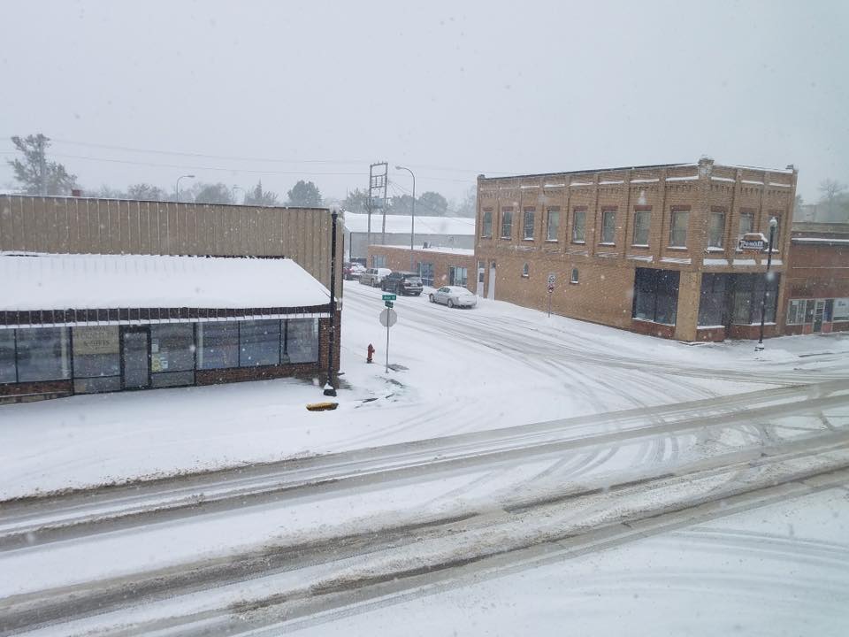
| Fall colors plastered by snow at Mina Lake on the morning of the 11th. Photo from NWS employee | Relatively warmer air blowing off the open waters melts snow on the east shores of Mina Lake on the morning of the 11th. Photo from NWS employee | Conditions at Webster by Daniel Basler Jr on the morning of the 11th | Accumulating snowfall in Pierre on the morning of the 10th in Pierre. Photo from Anthony Lueck |
 |
 |
 |
 |
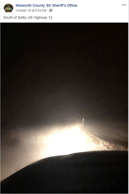
| Snow depth on the 13th in northwest Watertown, courtesy of Brent Nathaniel | Social media post by the Walworth County Sheriff's Office of conditions at 6:54 am on the 10th | Social media post by the Corson County Sheriff's Office of conditions at 3:20 pm on the 11th | Social media post by the Dewey County Sheriff's Office of conditions on the 11th |
.jpg) |
 |
||
| Social media post by the Lyman County Sheriff's Office of conditions on the 10th | Social media post by the Lyman County Sheriff's Office of conditions on the 11th |
Radar
 |
 |
 |
|
| Radar reflectivity overview (with approximate precipitation type) from Wednesday evening, Oct 9th through Saturday evening, Oct 12th | Snow, sleet and rain were all associated with this storm as it began on the 10th | An explanation for why different types of precipitation fall |
Storm Reports
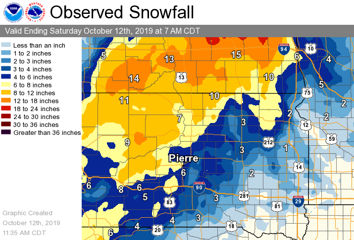
Storm total snowfall across South Dakota (as of 7am on the 12th)
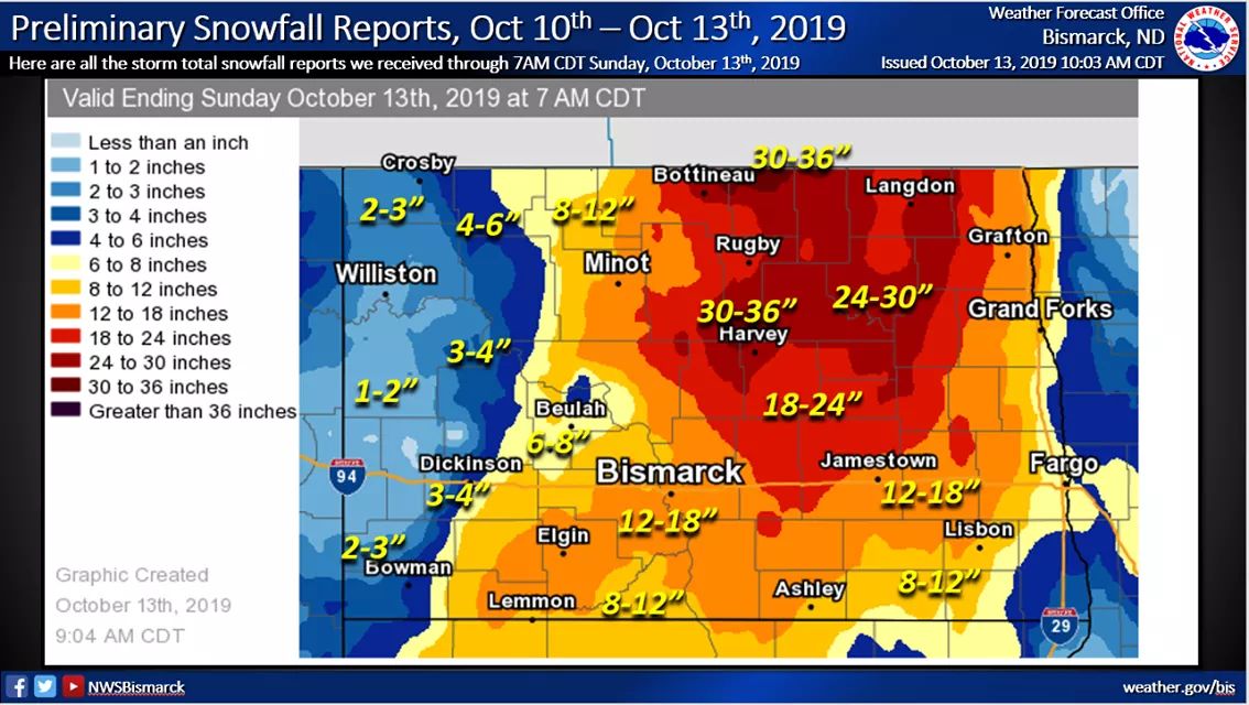
Storm total snowfall across North Dakota
Storm total liquid/liquid equivalent across the region
Listing of Storm Reports across the NWS Aberdeen's County Warning Area
..TIME... ...EVENT... ...CITY LOCATION... ...LAT.LON...
..DATE... ....MAG.... ..COUNTY LOCATION..ST.. ...SOURCE....
..REMARKS..
0700 AM Heavy Snow 11 SW Eureka 45.66N 99.80W
10/12/2019 M12.1 inch Campbell SD Cocorahs
Cocorahs station SD-CP-9 Eureka 11 WSW. 72
hour total.
0700 AM Heavy Snow 1 W Roscoe 45.45N 99.35W
10/12/2019 M11.3 inch Edmunds SD CO-OP Observer
CO-OP Observer station ROSS2 Roscoe. 72 hour
total.
0700 AM Heavy Snow 4 ESE Herreid 45.82N 100.01W
10/12/2019 M10.0 inch Campbell SD Cocorahs
Cocorahs station SD-CP-6 Herreid 3 ESE. 72
hour total.
0700 PM Heavy Snow Pollock 45.90N 100.28W
10/11/2019 M9.0 inch Campbell SD CO-OP Observer
CO-OP Observer station POLS2 Pollock. 48
hour total.
0600 PM Snow Roy Lake State Park 45.71N 97.43W
10/11/2019 M8.8 inch Marshall SD CO-OP Observer
24 hour snow total.
1124 AM Heavy Snow 4 E Pierpont 45.50N 97.75W
10/12/2019 E8.0 inch Day SD Public
From Thursday afternoon through Friday
afternoon...appx 8 inches. 6 to 7 foot
drifts around buildings on the property.
Lots of wind, too. Snowing again now with
more wind.
0700 AM Heavy Snow 2 SSE Claremont 45.64N 98.00W
10/12/2019 M7.5 inch Brown SD Cocorahs
Cocorahs station SD-BR-3 Claremont 2
SSE...48 hour total...radar estimated most
of this snow fell between 1 PM Thursday and
4 PM Friday.
0700 AM Heavy Snow Selby 45.50N 100.03W
10/12/2019 M7.4 inch Walworth SD CO-OP Observer
CO-OP Observer station SBYS2 Selby. 72 hour
total.
0600 AM Heavy Snow 7 E Hayes 44.37N 100.89W
10/12/2019 M7.0 inch Stanley SD CO-OP Observer
CO-OP Observer station AYES2 Hayes 6 E. 72
hour total.
0700 AM Heavy Snow Fort Pierre 44.36N 100.37W
10/12/2019 M6.8 inch Stanley SD Cocorahs
Cocorahs station SD-ST-6 Fort Pierre 0.5 SE.
72 hour total.
0600 PM Heavy Snow Timber Lake 45.43N 101.08W
10/11/2019 M6.6 inch Dewey SD CO-OP Observer
48 hour total.
1200 PM Heavy Snow Andover 45.41N 97.90W
10/12/2019 M6.5 inch Day SD CO-OP Observer
48 hour total.
0700 AM Snow Britton 45.78N 97.75W
10/12/2019 M5.7 inch Marshall SD CO-OP Observer
CO-OP Observer station BRIS2 Britton. 48
hour total.
1000 AM Snow Mobridge 45.54N 100.44W
10/12/2019 M5.6 inch Walworth SD CO-OP Observer
Official Mobridge observation. 72 hour
total.
0745 AM Snow Pierre 44.37N 100.33W
10/12/2019 M5.3 inch Hughes SD CO-OP Observer
Official Pierre observation. 72 hour total.
0700 AM Snow 3 NW Westport 45.68N 98.53W
10/12/2019 M5.0 inch Brown SD CO-OP Observer
CO-OP Observer station WPTS2 Westport 2 NW.
48 hour total.
0700 AM Snow Clark 44.88N 97.74W
10/12/2019 M4.5 inch Clark SD CO-OP Observer
48 hour total.
0700 AM Snow 4 W Sisseton 45.66N 97.12W
10/12/2019 M4.0 inch Roberts SD Cocorahs
Cocorahs station SD-RB-1 Sisseton 3 W. 48
hour total.
0700 AM Snow Turton 45.05N 98.10W
10/12/2019 M4.0 inch Spink SD CO-OP Observer
CO-OP Observer station TURS2 Turton. 48 hour
total.
0600 AM Snow 3 ESE Aberdeen 45.46N 98.41W
10/12/2019 M4.0 inch Brown SD Official NWS Obs
Official 48 hour total at NWS Aberdeen.
0700 PM Snow Pollock 45.90N 100.29W
10/11/2019 M4.0 inch Campbell SD CO-OP Observer
24 hour snow total.
0620 PM Snow Chelsea 45.17N 98.74W
10/11/2019 M4.0 inch Faulk SD Public
48 Hour snow total.
0700 AM Snow 6 SSW Bath 45.39N 98.37W
10/12/2019 M3.4 inch Brown SD Cocorahs
Cocorahs station SD-BR-23 Bath 5 SSW. 72
hour total.
0700 AM Snow 12 N Highmore 44.70N 99.41W
10/12/2019 M3.0 inch Hyde SD Cocorahs
Cocorahs station SD-HY-1 Highmore 12 N. 72
hour total.
0800 AM Snow 2 S Doland 44.87N 98.10W
10/12/2019 M2.9 inch Spink SD CO-OP Observer
CO-OP Observer station DOLS2 Doland 2 S. 48
hour total.
0700 AM Snow Presho 43.90N 100.06W
10/12/2019 M2.9 inch Lyman SD Cocorahs
Cocorahs station SD-LY-1 Presho 0.3 SSW. 72
hour total.
0800 AM Snow Faulkton 45.03N 99.13W
10/12/2019 M2.7 inch Faulk SD CO-OP Observer
CO-OP Observer station FAUS2 Faulkton 1 NW.
72 hour total.
0800 AM Snow 2 NW Spottswood 44.68N 98.53W
10/12/2019 M2.5 inch Spink SD Cocorahs
Cocorahs station SD-SP-1 Tulare 4.5 SSW. 48
hour total.
0600 AM Snow 2 NE Mina 45.46N 98.73W
10/12/2019 M2.2 inch Edmunds SD Cocorahs
Cocorahs station SD-ED-14 Mina 2 NE. 48 hour
total.
0900 AM Snow 3 ESE Watertown 44.90N 97.11W
10/12/2019 M1.5 inch Codington SD CO-OP Observer
CO-OP Observer station WRTS2 2.7 E
Watertown. 48 hour total
Additional Information
Perspective
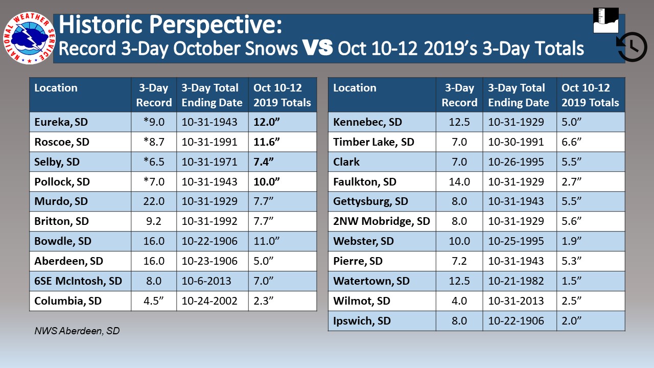
Summaries from other NWS Offices
 |
Media use of NWS Web News Stories is encouraged! Please acknowledge the NWS as the source of any news information accessed from this site. |
 |