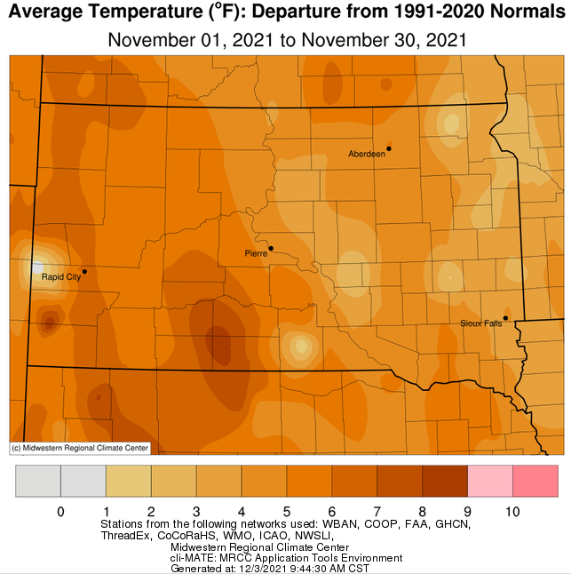
November 2021 finished above average in terms of temperatures, anywhere from 2 to 6 degrees above normal overall. Kennebec tied their 9th warmest November on record, and Aberdeen, Mobridge and Watertown all reached record daily highs on the 23rd or 29th (57 to 60 degrees).
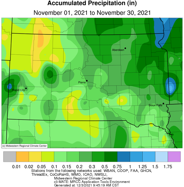
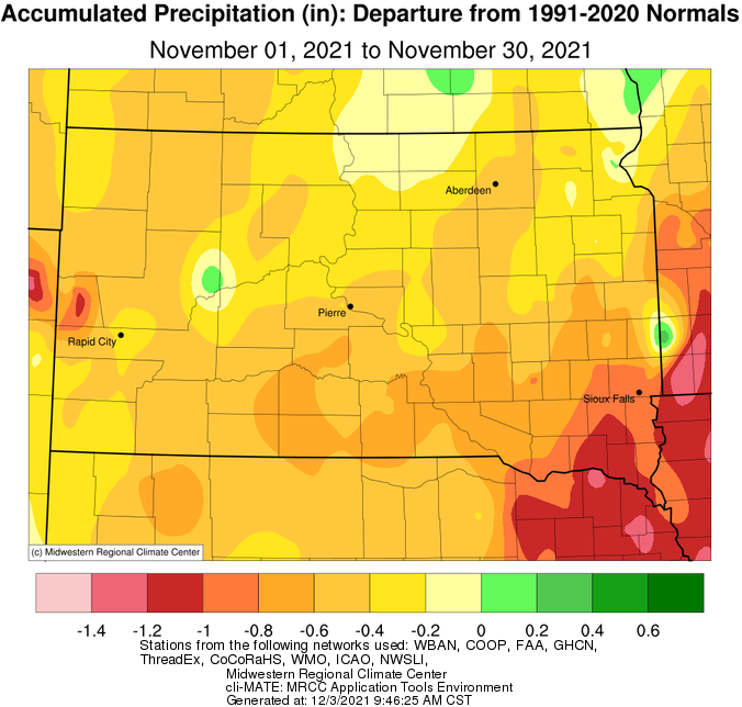
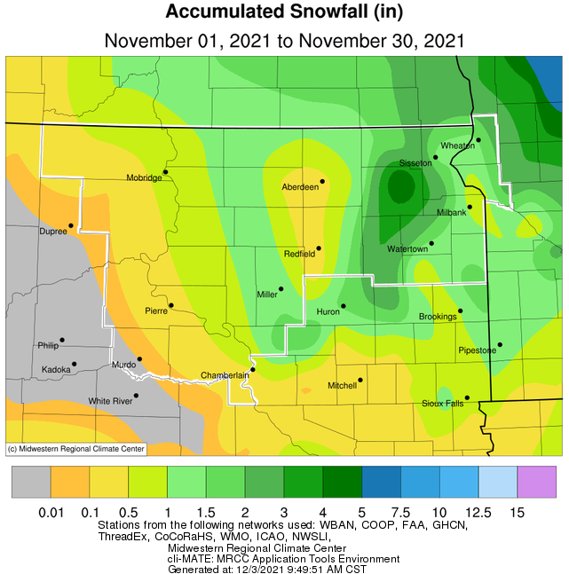
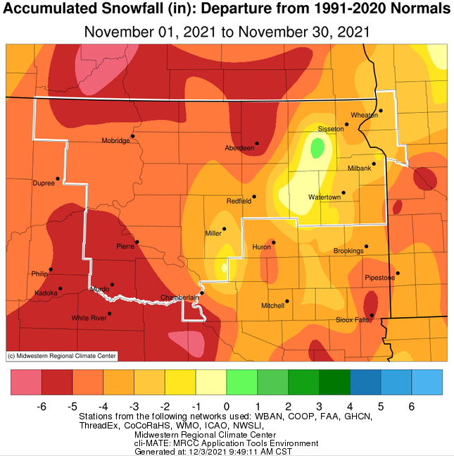
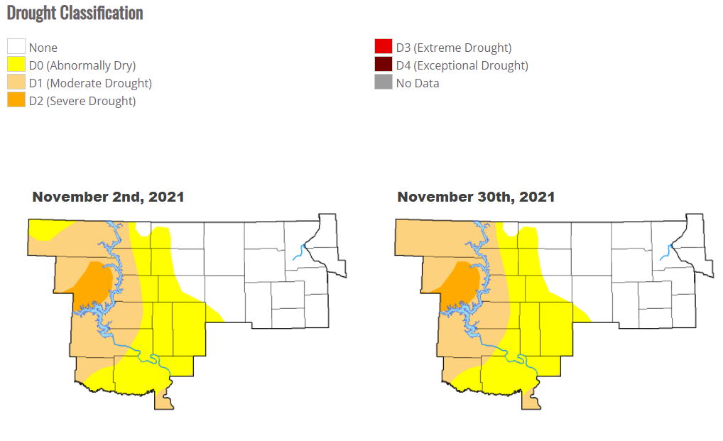
Precipitation-wise, the area was drier than normal across the board by a few tenths to over half an inch. Most areas only picked up 0.10 to 0.75” of total moisture. Drought conditions remained unchanged from the beginning to end of the month with Moderate to Severe drought across portions of Central South Dakota. The combination of warm temperatures and a lack of moisture led to much below normal snowfall compared to normal for most, by as much as 6”. The main snow-producer this month was accompanied by strong winds, which led to blizzard conditions on Thursday night, Nov 11th into Friday morning, Nov 12th across portions of the Prairie Coteau area. Webster reported the most snow with this system with 5.0”, but these types of amounts were fairly localized.
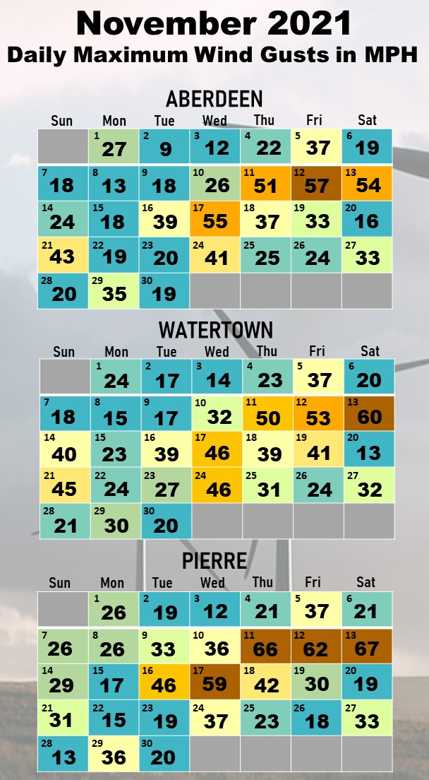
A lack of moisture didn’t mean a lack of active weather from strong low pressure systems, however. In addition to the blizzard event, in which wind gusts of 50 to 70 mph were recorded across the area, high winds were recorded on the evening of Saturday the 13th (wind gusts of 55 to 70+ mph) and Wednesday the 17th (45 to 60+ mph) as well. Many high-profile vehicles were tipped due to these winds, and fire weather conditions were high to very high as a result.
|
November 2021 |
||||
|
Temperature Data |
Aberdeen |
Sisseton |
Wheaton |
Watertown |
|
Warmest Temperature / Date |
68 / 5, 6th |
72 / 6th |
68 / 6th |
68 / 6th |
|
Coldest Temperature / Date |
3 / 25th |
6 / 25th |
4 / 25, 26th |
3 / 25th |
|
Average High / Departure from Normal |
47.7 / +5.2 |
46.2 / +4.7 |
41.7 / +1.2 |
44.2 / +4.4 |
|
Average Low / Departure from Normal |
24.2 / +4.8 |
26.5 / +4.1 |
25.4 / +2.6 |
24.6 / +3.3 |
|
Monthly Average / Departure from Normal |
35.9 / +5.0 |
36.3 / +4.4 |
33.6 / +2.0 |
34.4 / +3.8 |
|
Precipitation Data |
|
|
|
|
|
Monthly Precipitation / Departure from Normal |
0.26 / -0.48 |
0.75 / +0.11 |
0.85 / -0.23 |
0.54 / -0.14 |
|
Most Precipitation in 24 hours / Date |
0.13 / 10th |
0.50 / 10th |
0.64 / 10th |
0.28 / 10th |
|
Monthly Snowfall / Departure from Normal |
0.3 / -6.2 |
1.2 / -3.4 |
1.3 / -2.6 |
1.4 / -3.1 |
|
Most Snow in 24 hours / Date |
0.3 / 12th |
0.9 / 12th |
1.2 / 12th |
1.3 / 12th |
|
|
|
|
|
|
|
Temperature Data |
Pierre |
Kennebec |
Mobridge |
Timber Lake |
|
Warmest Temperature / Date |
70 / 6, 16th |
75 / 6th |
70 / 6th |
68 / 6th |
|
Coldest Temperature / Date |
6 / 25th |
5 / 25th |
3 / 25th |
4 / 25th |
|
Average High / Departure from Normal |
51.8 / +6.9 |
54.2 / +7.1 |
50.3 / +6.1 |
48.7 / +6.1 |
|
Average Low / Departure from Normal |
25.9 / +2.7 |
26.9 / +4.6 |
26.0 / +3.2 |
25.4 / +3.7 |
|
Monthly Average / Departure from Normal |
38.8 / +4.7 |
40.6 / +5.9 |
38.1 / +4.6 |
37.1 / +5.0 |
|
Precipitation Data |
|
|
|
|
|
Monthly Precipitation / Departure from Normal |
0.25 / -0.52 |
0.18 / -0.53 |
0.25 / -0.18 |
0.14 / -0.43 |
|
Most Precipitation in 24 hours / Date |
0.14 / 8th |
0.15 / 10th |
0.23 / 10th |
0.11 / 10th |
|
Monthly Snowfall / Departure from Normal |
T / -6.3 |
0 / -6.0 |
T / -3.6 |
0.1 / -4.3 |
|
Most Snow in 24 hours / Date |
T / 11,12,24th |
N/A |
T / Several |
0.1 / 24th |
November 2021 temperature departures from normal, from the Midwestern Regional Climate Center
Precipitation totals (left) and departures from normal (right), from the Midwestern Regional Climate Center
Snowfall totals (left) and departures from normal (right), from the Midwestern Regional Climate Center
US Drought Monitor comparison from the beginning of the month to the end (little to no change)
Daily maximum wind gusts at Aberdeen, Watertown and Pierre through the month