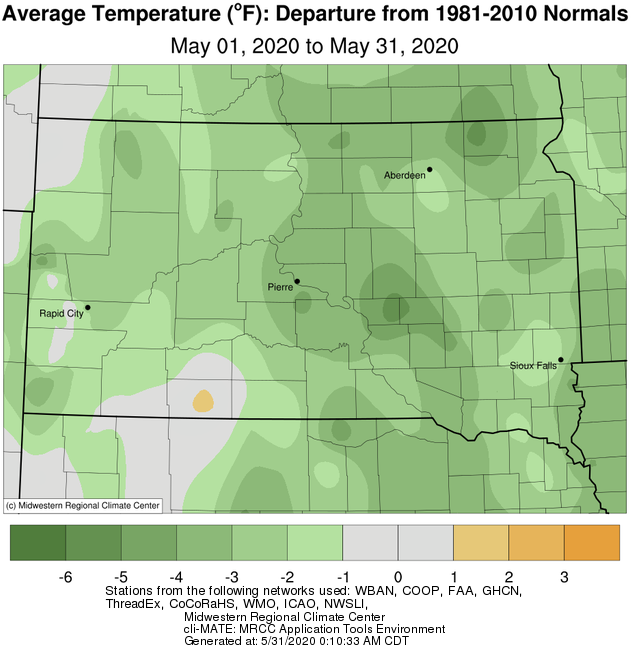
May 2020 finished below average across the board, between 1 and 5 degrees. A particularly cold stretch occurred from the 4th through the 12th, during which time Pierre set a daily record low on the 11th of 23 degrees (25 in 1946). This happened to be just 2 degrees away from tying an all-time record low for the month of May. Additionally, a trace of snow fell at Aberdeen, Mobridge and Watertown with a system on the 9th. The last nights of widespread frost took place on the 11th and 12th, which marked the beginning of the growing season.
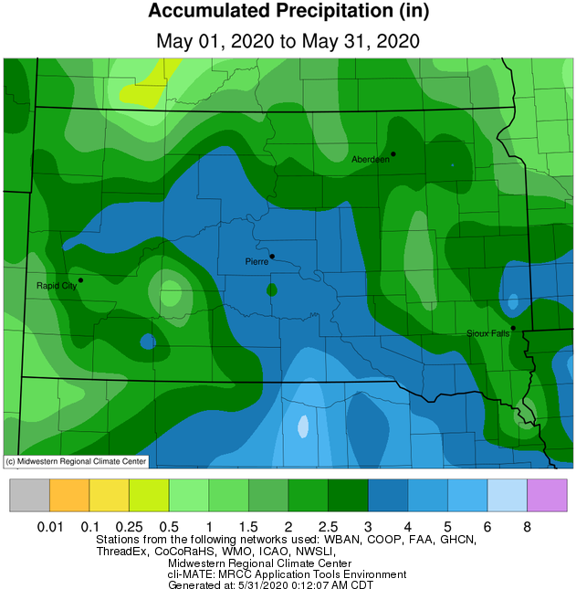
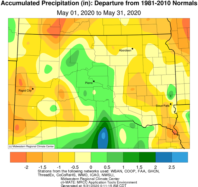
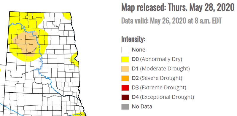
Precipitation-wise, central South Dakota finished slightly above average for the month, but north central and northeastern South Dakota and west central Minnesota finished below average by upwards of 1.5”. There were two main stand-out events rain-wise: The 4th and 23-24th. A slow-moving and widespread shield of steady rain impacted the area on the 4th, when daily record totals were set at Aberdeen with 2.11” (1.35” in 1905), Watertown with 0.90” (0.75” in 1912) and Pierre with 1.11” (1.04” in 1905). Unusually, Aberdeen recorded approximately 20 consecutive hours of rainfall from 7:30 am on the 4th to 3:30 am on the 5th, and Watertown approximately 22 consecutive hours from 1:00 pm on the 4th to 11:00 am on the 5th. May 23-24th featured a slow-moving complex of thunderstorms across central South Dakota when generally 1-3 inches of rain fell. As of June 1st, the James River at Stratford and Columbia continue their incredible streak of being above flood stage. Meanwhile, portions of Corson County fell into drought (D1/moderate classification) due to a continued stretch of below average precipitation.
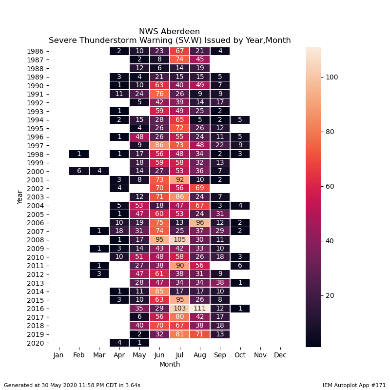
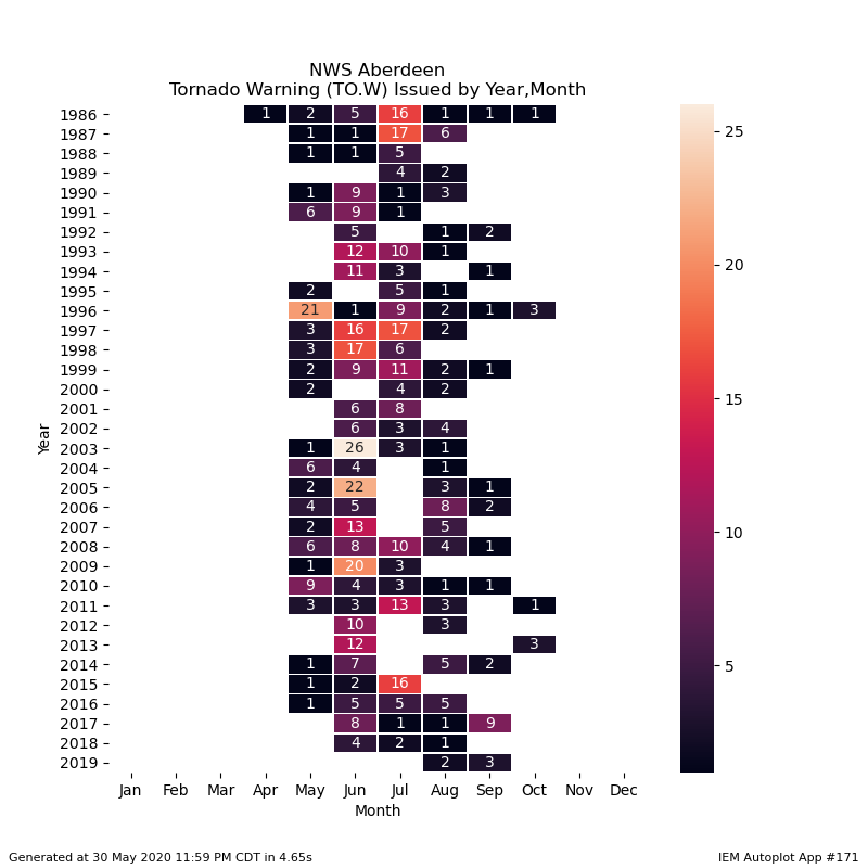
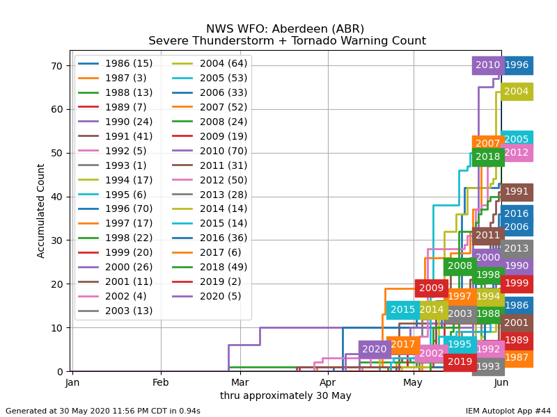
Back-to-back Mays now, 2019 and 2020, have been incredibly quiet in terms of severe weather across NWS Aberdeen’s forecast area. The sole warning issued, a severe thunderstorm warning, was for portions of Stanley County on the 23rd. Since 1986, only two other Mays have had fewer warnings since records began in 1986: zero in 1993 and 2002. Historically, May can be a very volatile month for storms in South Dakota and west central Minnesota. A few of the most significant include the Tripp County F5 tornado on the 8th in 1965, the Spencer, SD F4 tornado on the 30th in 1998, the Bowdle EF4 tornado on the 22nd in 2010, as well as several F/EF3 tornadoes including one that began in Aberdeen on the 31st in 1996.
|
May 2020 |
||||
|
Temperature Data |
Aberdeen |
Sisseton |
Wheaton |
Watertown |
|
Warmest Temperature / Date |
87 / 27th |
85 / 27th |
83 / 27th |
82 / 27th |
|
Coldest Temperature / Date |
29 / 8, 11, 12th |
25 / 12th |
28 / 12th |
25 / 11th |
|
Average High / Departure from Normal |
67.1 / -1.6 |
65.1 / -4.3 |
65.5 / -3.0 |
63.8 / -3.8 |
|
Average Low / Departure from Normal |
44.9 / +0.8 |
43.8 / -1.3 |
45.1 / -0.6 |
44.1 / -0.5 |
|
Monthly Average / Departure from Normal |
56.0 / -0.4 |
54.5 / -2.8 |
55.3 / -1.8 |
54.0 / -2.1 |
|
Precipitation Data |
|
|
|
|
|
Monthly Precipitation / Departure from Normal |
2.69 / -0.42 |
1.75 / -0.97 |
1.16 / -1.52 |
2.34 / -0.30 |
|
Most Precipitation in 24 hours / Date |
2.11 / 4th |
0.64 / 4th |
0.66 / 4th |
0.90 / 4th |
|
Monthly Snowfall / Departure from Normal |
T / -0.0 |
0 / -0.0 |
0 / -0.0 |
T / -0.0 |
|
Most Snow in 24 hours / Date |
T / 9th |
0 / N/A |
0 / N/A |
T / 9th |
|
Temperature Data |
Pierre |
Kennebec |
Mobridge |
Timber Lake |
|
Warmest Temperature / Date |
82 / 27th |
83 / 27, 31st |
83 / 22,23,27 |
82 / 23rd |
|
Coldest Temperature / Date |
23 / 11th |
24 / 11th |
25 / 11th |
23 / 11th |
|
Average High / Departure from Normal |
66.0 / -4.2 |
68.4 / -4.5 |
67.9 / -0.5 |
67.5 / -2.2 |
|
Average Low / Departure from Normal |
43.5 / -2.2 |
44.2 / -1.7 |
43.1 / -0.8 |
42.1 / -1.9 |
|
Monthly Average / Departure from Normal |
54.7 / -3.2 |
56.5 / -2.9 |
55.5 / -0.7 |
55.0 / -2.0 |
|
Precipitation Data |
|
|
|
|
|
Monthly Precipitation / Departure from Normal |
3.45 / +0.30 |
3.41 / +0.25 |
2.12 / -0.70 |
3.47 / +0.63 |
|
Most Precipitation in 24 hours / Date |
1.11 / 4th |
1.03 / 4th |
0.95 / 24th |
1.89 / 24th |
|
Monthly Snowfall / Departure from Normal |
0 / -0.0 |
0 / -0.0 |
T / -0.1 |
0 / -0.2 |
|
Most Snow in 24 hours / Date |
0 / N/A |
0 / N/A |
T / 9th |
0 / N/A |
Temperature departures from normal over the course of May 2020, from the Midwestern Regional Climate Center
Precipitation totals (left) and departures from normal (right) from May 2020, from the Midwestern Regional Climate Center
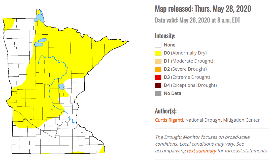
US Drought Monitor released May 28th, showing pockets of abnormally dry and even drought conditions across the area.
The chart below, from the Iowa Environmental Mesonet, displays the total combined number of Severe Thunderstorm and Tornado Warnings issued by the NWS in Aberdeen up to midnight on May 31st, compared to other years on record.
The charts below from the Iowa Environmental Mesonet display the number of Severe Thunderstorm (left) and Tornado (right) Warnings issued by the NWS in Aberdeen up to midnight on May 31st *by month*, compared to other years on record.