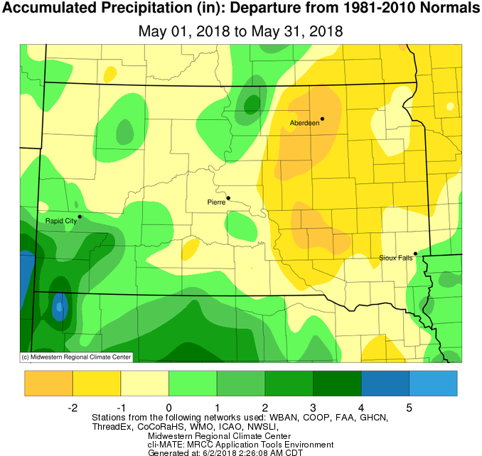
May 2018 was either very wet or very dry, depending on your location. While a generally active pattern brought several opportunities for precipitation, Aberdeen recorded their 7th driest May on record with just 0.52” of moisture (1900 holds the record at 0.25”). This is 0.13” less than was recorded in May 2017. However, 2017 was drier than 2018 from January 1st to May 31st in Aberdeen by 0.58” (3.76” below normal vs 3.18” below normal respectively). On the contrary, an exceptionally heavy rainfall event took place across portions of north central South Dakota on May 17th. Training thunderstorms, those which develop and pass over the same areas over extended periods of time, led to extreme rainfall reports including 13.15” four miles northwest of Long Lake, SD. These measurements are being vetted to determine if they meet standards necessary to qualify as South Dakota’s state 24 hour precipitation record (currently held by Groton, SD with 8.74” recorded on May 6th, 2007). This heavy rainfall contributed to the failure of the Hiddenwood Lake Dam about 4 miles north of Selby, SD on the morning of May 18th. Several area roadways were submerged as a result. More information on the May 17th event can be found here: https://www.weather.gov/abr/2018May17_18_severe_flooding
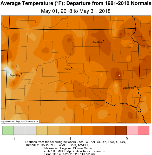
May 2018 was very warm across the board, May 24-27th in particular. The following were record daily high temperatures: Watertown reached 96° on the 27th, Sisseton reached 90° on the 24th, 93° on the 25th, and 95° on the 26th, and Aberdeen reached 94° on the 25th, 97° on the 26th and 101° on the 27th. This is only the 4th year on record in Aberdeen when a May day reached at least 100° (once in 2018, 1959 and 1931, and 7 times in 1934). This was the 3rd warmest May on record in Aberdeen (64.5° average temperature vs 1st place 69° in 1934), the 3rd warmest May on record in Sisseton (64.3° average temperature vs 1st place 70.3° in 1934), the 3rd warmest May on record in Wheaton (64.8° vs 1st place 67.1° in 1977, the 4th warmest in Timber Lake, 7th in Pierre and Watertown, and 8th warmest in Kennebec. This is an abrupt turn-around from just a month ago. Amazingly, Aberdeen recorded their 2nd coldest April on record this year, and both Sisseton and Wheaton recorded their 3rd coldest April on record this year. “Normal” weather is just the average of extremes in the Northern Plains after all.
|
MAY 2018 |
||||
|
Temperature Data |
Aberdeen |
Sisseton |
Wheaton |
Watertown |
|
Warmest Temperature / Date |
101 / 27th |
97 / 27th |
94 / 27th |
96 / 27th |
|
Coldest Temperature / Date |
29 / 2nd |
33 / 2nd |
35 / 2nd |
35 / 2nd |
|
Average High / Departure from Normal |
80.1 / +11.4 |
78.7 / +9.3 |
77.7 / +9.2 |
74.8 / +7.2 |
|
Average Low / Departure from Normal |
49.0 / +4.9 |
51.7 / +6.6 |
51.9 / +6.2 |
49.9 / +5.3 |
|
Monthly Average / Departure from Normal |
64.5 / +8.1 |
65.2 / +7.9 |
64.8 / +7.1 |
62.4 / +6.3 |
|
Precipitation Data |
|
|
|
|
|
Monthly Precipitation / Departure from Normal |
0.52 / -2.59 |
1.80 / -0.92 |
1.44 / -1.24 |
1.67 / -0.97 |
|
Most Precipitation in 24 hours / Date |
0.33 / 14th |
0.78 / 27th |
0.39 / 27th |
1.00 / 8th |
|
Temperature Data |
Pierre |
Kennebec |
Mobridge |
Timber Lake |
|
Warmest Temperature / Date |
91 / 26th |
94 / 27th |
93 / 31st |
91 / 26th |
|
Coldest Temperature / Date |
35 / 2nd |
36 / 2nd |
36 / 2nd |
38 / 20th |
|
Average High / Departure from Normal |
76.5 / +6.3 |
78.9 / +6.0 |
77.4 / +9.0 |
75.4 / +5.7 |
|
Average Low / Departure from Normal |
51.0 / +5.3 |
50.9 / +5.0 |
50.7 / +6.8 |
48.9 / +4.9 |
|
Monthly Average / Departure from Normal |
63.8 / +5.9 |
64.9 / +5.5 |
64.0 / +7.8 |
62.2 / +5.3 |
|
Precipitation Data |
|
|
|
|
|
Monthly Precipitation / Departure from Normal |
2.78 / -0.37 |
3.74 / +0.17 |
3.33 / +0.51 |
2.77 / -0.07 |
|
Most Precipitation in 24 hours / Date |
1.26 / 17th |
0.86 / 11th |
2.09 / 17th |
2.3 / 18th |
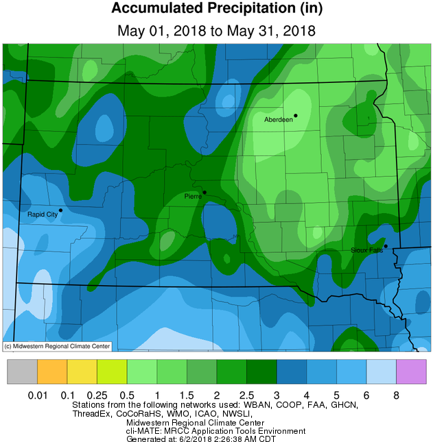
Total precipitation accumulation in May 2018, courtesy of the Midwestern Regional Climate Center
Precipitation departures in May 2018, courtesy of the Midwestern Regional Climate Center
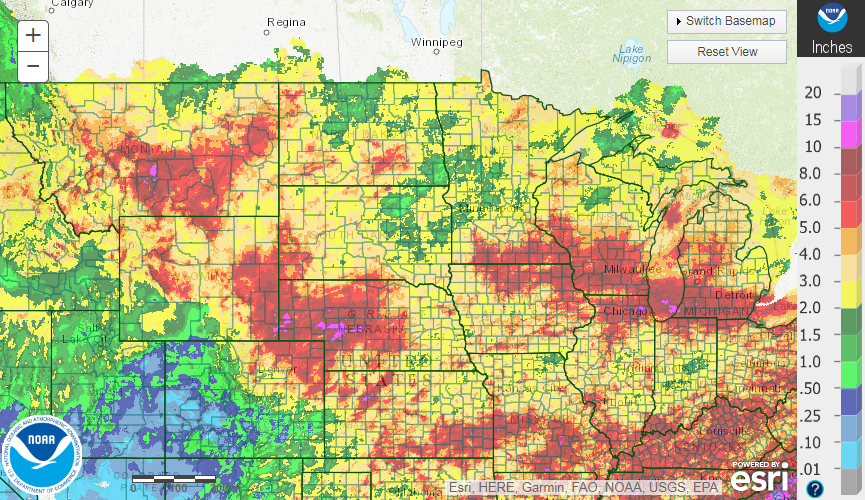
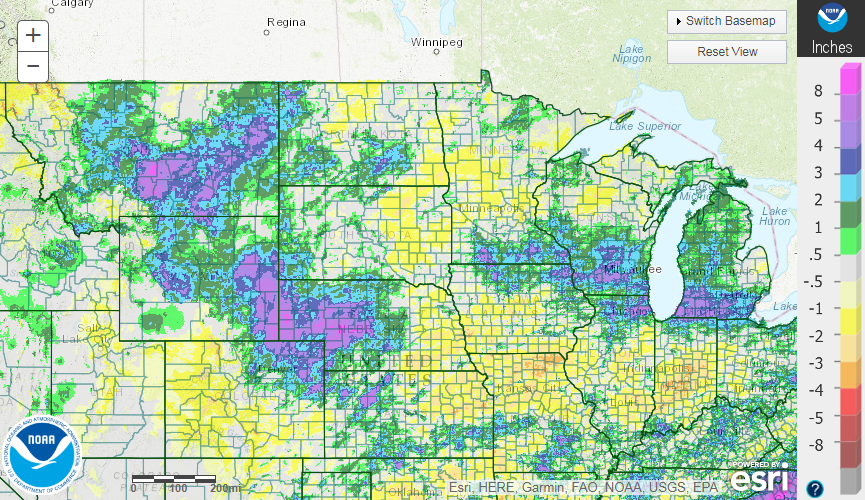
A wider view of precipitation totals (first) and departures (second) during May 2018 across the Northern Plains for perspective, from https://water.weather.gov/ahps/
Temperature departures in May 2018, courtesy of the Midwestern Regional Climate Center