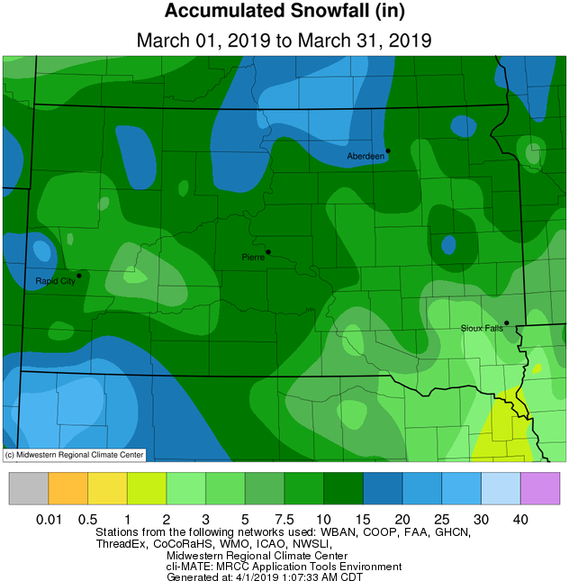
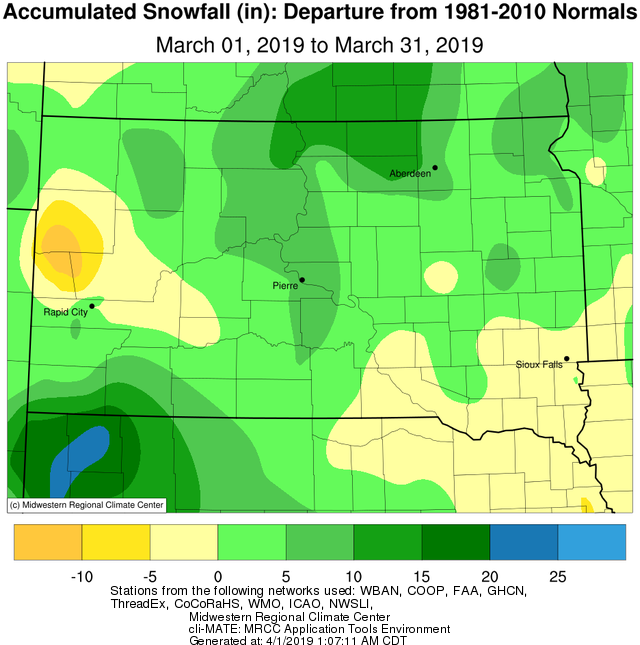
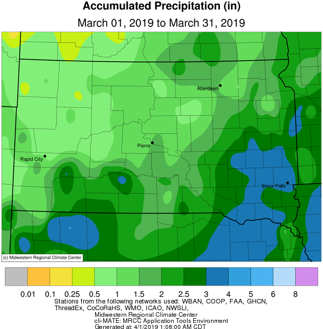
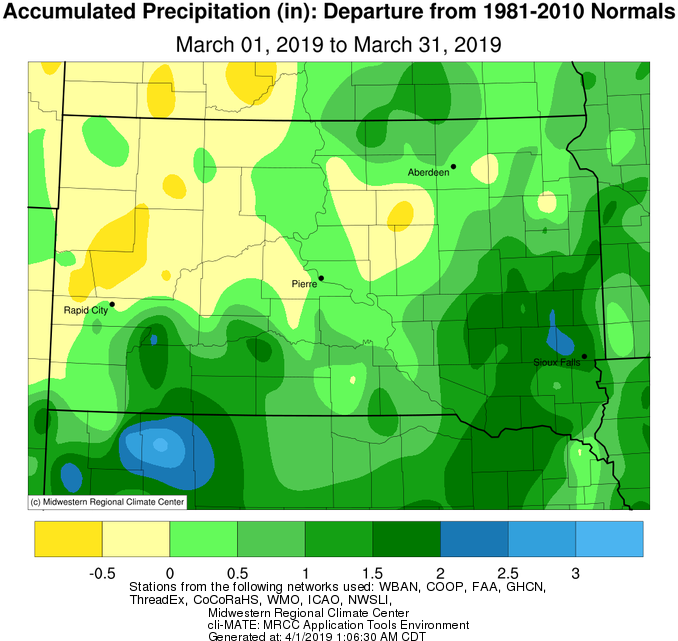
March 2019 featured two significant winter storm systems. The first, on March 9th, was a wet heavy snow producer of generally 6-12 inches across north central/northeastern South Dakota and west central Minnesota (https://www.weather.gov/abr/March9thWinterStormSummary). The second, on March 13-14th, was very severe and produced heavy rain, freezing rain, heavy snow, high winds, widespread blizzard conditions, and/or major drifting across the area. Long-lasting impacts ensued (https://www.weather.gov/abr/ReviewMarch13-14Blizzard). Daily snowfall and/or precipitation records were set on the 9th at Aberdeen, Sisseton and Mobridge, and on the 13th at Pierre, Sisseton and Watertown. The vast majority of the area observed above average snowfall and precipitation totals for the month, largely as a result of these storms (though two 2-4” type snowfall events also took place before the March 9th storm). Mobridge observed their 5th snowiest March on record with 18.1”, Timber Lake 9th with 16.1”, and Pierre 6th with 15.9”.
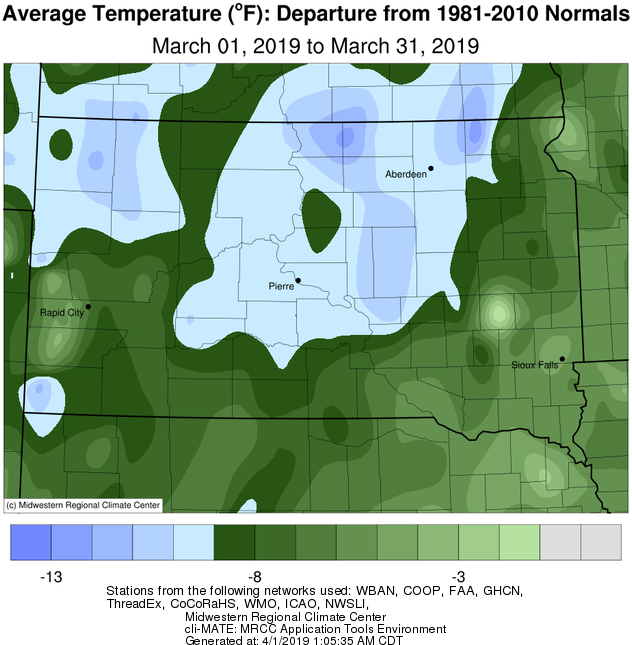
Much below average temperatures, on the order of generally 5 to 12 degrees, were observed this March 2019 on a whole. Exceptionally cold air overtook the area on the 2nd-3rd. On the 3rd, daily record low temperatures were set at Aberdeen, -20 F, and Pierre, -16 F, and daily record cold high temperatures were set at Aberdeen, -1 F, Mobridge, 2 F, Watertown, -5 F, and Sisseton, -2 F. Furthermore, Pierre set a record cold high temperature for the month of March of 0 F. Aberdeen reached 32 degrees for the first time in 43 consecutive days on the 11th (6th longest streak on record), Pierre 36 consecutive days ending on the 10th (2nd longest), Timber Lake 37 consecutive days ending on the 11th (tied 5th longest), Mobridge 38 consecutive days ending on the 11th (tied 5th), Wheaton 60 consecutive days ending on the 10th (3rd longest) and Sisseton 62 consecutive days ending on the 11th (2nd longest). Pierre recorded their 10th coldest March on record.
Significant snow depths reduced during the March 13-14th system (on the warm/rain side), and gradually after the system once temperatures warmed. Moderate, major and even historic flooding in some cases resulted across the Missouri, James, Big Sioux and other rivers/basins due to snowmelt and ice jams for much of the final third of the month, even without any additional meaningful precipitation. Overland flooding occurred in the absence of rivers as well, since snowmelt was unable to soak into the frozen ground. The scope and magnitude of this season’s snowmelt-variety flooding is rare, with only the springs of 2011 and 1997 being comparable in recent history. Significant impacts to a great number of roads and properties continue, and continue to expand, as April begins.
|
March 2019 |
||||
|
Temperature Data |
Aberdeen |
Sisseton |
Wheaton |
Watertown |
|
Warmest Temperature / Date |
52°/ 27th |
54°/ 27th |
53°/ 27th |
57°/ 27th |
|
Coldest Temperature / Date |
-20°/ 3rd |
-15°/ 3rd |
-17°/ 3rd |
-19°/ 2nd |
|
Average High / Departure from Normal |
30.6°/ -9.4° |
31.2°/ -8.1° |
33.1°/ -3.7° |
31.1°/ -7.8° |
|
Average Low / Departure from Normal |
11.1°/ -8.7° |
-15.5°/ -5.3° |
17.3°/ -0.7° |
14.2°/ -5.7° |
|
Monthly Average / Departure from Normal |
20.9°/ -9.0° |
23.3°/ -6.7° |
25.2°/ -2.2° |
22.6°/ -6.8° |
|
Precipitation Data |
||||
|
Monthly Precipitation / Departure from Normal |
1.33”/+0.17” |
1.88”/+0.76” |
2.12”/ +0.64” |
2.66”/+1.55” |
|
Most Precipitation in 24 hours / Date |
0.80”/ 9th |
0.89”/ 13th |
1.03”/ 13th |
1.49”/13th |
|
Monthly Snowfall / Departure from Normal |
16.4” / +9.2” |
14.8” / +6.5” |
11.5” / +3.2” |
7.2”/ +1.0” |
|
Most Snow in 24 hours / Date |
9.3” / 9th |
9.0” / 9th |
6.7” / 9th |
4.6” / 1st |
|
Temperature Data |
Pierre |
Kennebec |
Mobridge |
Timber Lake |
|
Warmest Temperature / Date |
60°/ 31st |
61°/ 31st |
53°/ 27, 31st |
53°/ 27th |
|
Coldest Temperature / Date |
-16°/ 3rd |
-19°/ 3rd |
-20°/ 2nd |
-21°/ 3rd |
|
Average High / Departure from Normal |
33.7°/ -11.7° |
35.8°/ -12.1° |
32.5°/ -10.1° |
32.1°/ -11.1° |
|
Average Low / Departure from Normal |
16.6°/ -6.9° |
16.6°/ -6.8° |
13.6°/ -7.5° |
13.6°/ -7.9° |
|
Monthly Average / Departure from Normal |
25.1°/ -9.3° |
26.5°/ -9.2° |
23.0°/ -8.9° |
22.6°/ -9.8° |
|
Precipitation Data |
||||
|
Monthly Precipitation / Departure from Normal |
1.79”/ +0.56” |
1.44”/ +0.18” |
1.04”/+0.14” |
1.17”/ +0.02” |
|
Most Precipitation in 24 hours / Date |
0.68”/ 13th |
0.79”/ 13th |
0.46”/ 9th |
0.62”/ 9th |
|
Monthly Snowfall / Departure from Normal |
15.9 / +9.9” |
10.3” / +2.3 |
18.1”/ +12.2” |
14.4”/ +6.8 |
|
Most Snow in 24 hours / Date |
5.5”/ 13th |
3.5” / 14th |
8.9” / 9th |
8.7” / 9th |
March 2019 average temperature departure, from the Midwestern Regional Climate Center
March 2019 snowfall totals (left) and departures (right), from the Midwestern Regional Climate Center
March 2019 precipitation totals (left) and departures (right), from the Midwestern Regional Climate Center
Based on temperature, snowfall and snow depth, the Accumulated Winter Season Severity Index (AWSSI) aims to gauge how severe the winter season has been. As of March 31st, many stations across the High Plains have recorded an either "Severe" or "Extreme" winter.
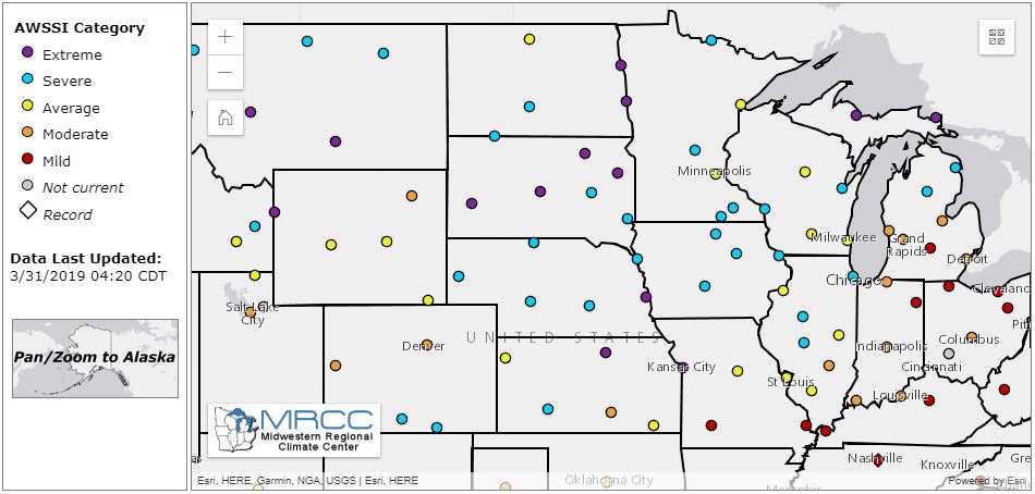
Looking closer at the three stations within our forecast area, Aberdeen, Watertown, and Pierre, we can see at what point in the season different categories were reached, as well as perspective on how the current season ranks in terms of the most extreme winter on record using the criteria mentioned earlier.
.jpeg)
.jpeg)
.jpeg)

