The second major severe weather outbreak in a 72 hour time span took place across South Dakota from Sunday evening, June 21st through the Monday morning of June 22nd. Some of the same areas that were hit hard by storms on the 19th-20th were impacted once again. Below is a summary of the information we have gathered up to the afternoon of June 22nd - our focus once again will be on the areas affected within our County Warning Area.
Much of the day was sunny and pleasant across the state on Sunday, June 21st - also Father's Day and the Summer Solstice. However many ingredients for severe weather were inconspicuously in place or developing. By the time the night was over, many distinct severe storms led to rounds of wind and hail damage. It began as thunderstorms fired off during early evening on the 21st in the form of supercells across northwestern South Dakota and southwestern North Dakota. Several tornadoes were associated with one of these supercells in Perkins and Ziebach Counties, the first of which touched down at 6:56 pm MDT, before the storm weakened as it moved into Dewey County. Meanwhile, a bowing line of storms had developed across south central ND and went on to impact McPherson and Brown Counties with hail up to 2.75 inches in the Richmond Lake Rec Area at 12:05 am CDT. A couple of supercells then tracked over Highway 12 from Bath to Milbank producing large hail.
What turned out to be the main event then took shape further west. By 12:30 am CDT, supcercells developed across the northern Black Hills. These storms rapidly moved east at around 60 mph and morphed into a derecho. By 2:20 am, the storm entered western Stanley County and at 2:32 am it produced a wind gust of 122 mph near Hayes, as measured by a home weather station. One person was injured here as a camper was rolled. An office building was also moved and grain bins were destroyed in the Hayes area. To put this kind of wind speed in perspective, an EF2 tornado has wind speeds of 111-135 mph, and a category 3 hurricane has wind speeds of 111-129 mph. The derecho continued blasting east and reached Pierre and Fort Pierre around the 3:00 am timeframe. Major widespread damage occured in both cities as winds up to 81 mph were measured at the Pierre airport at 3:09 am. Reports of damage include countless large trees down, a flipped mobile home and semi trucks, at least one grain silo and several buildings damaged. Winds as high as 70+ mph continued for some time after the passage of the storm in Pierre, which exacerbated the situation. This storm would then move on to affect Lyman, Hyde, Hand, and Buffalo Counties (the same areas that had been devastated by a similar system 2 days prior) before moving into southeastern SD, resulting in severe damage in the Sioux Falls area. The storm continued eastward through the morning and afternoon hours on the 22nd to affect southern Minnesota, northern Iowa, and Ilinois producing copious wind damage, which is why this system has now been classified as a derecho.
Several other storms, some severe across Spink and Hamlin counties, developed over the next several hours leading to additional heavy rain on already saturated soils. Rainfall reports include 3.35" in Webster, 2.43" one mile SW of Pierre, 1.56" 7.6 miles ENE of Watertown, and 0.95" at the airport in Aberdeen. The last of the activity exited South Dakota by around 6 am CDT.
For an interactive map and complete listing of storm reports, visit https://nwschat.weather.gov/lsr/#ABR,UNR,FSD,BIS/201506210500/201506221700/0100
Radar reflectivity of the event
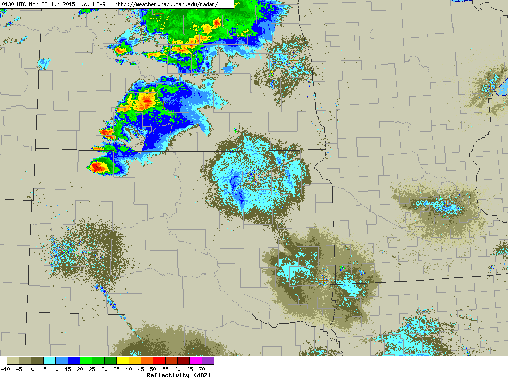
Still images of radar reflectivity of the bow echo across Stanley County, at 2:20 am left and at 2:53 am right
.JPG)
Collection of large hail at Richmond Lake, from MacKenzie Poel

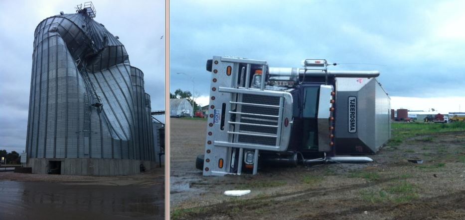
Damage in Fort Pierre, from DRG News (KGFX/KOLY) @DGRNews
Damage in Pierre, from Shelby via Matt Holsen @KELOHolsen (left) and from Jackie Hig @NaturalLifeImag (right)

Damage at the State Capitol, from Tony Venhuizen @Tony_Venhuizen
.JPG)
Damage east of Pierre, from DRG News (KGFX/KOLY) @DRGNews

24 hour total event rainfall amounts
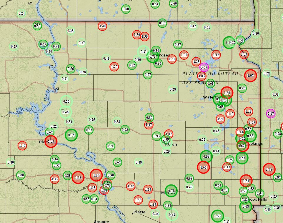
LOCATION                     AMOUNT    TIME/DATE
WEBSTER                      3.35 IN   0800 AM 06/22
7 NW HAYTI                   3.00 IN   0600 AM 06/22
4 W HAYTI                    2.60 IN   0600 AM 06/22
LEOLA                        2.50 IN   0600 AM 06/22
ANDOVER                      2.45 IN   1200 PM 06/22
1 SW PIERRE                  2.43 IN   1128 AM 06/22
WEBSTER 8.6 NW               2.25 IN   0700 AM 06/22
PIERRE 1.3 S                 2.00 IN   0700 AM 06/22
FORT PIERRE 0.5 SE           1.85 IN   0700 AM 06/22
HAYTI 1W                     1.83 IN   0800 AM 06/22
HAYTI                        1.70 IN   0800 AM 06/22
PIERRE CAPITOL               1.65 IN   0705 AM 06/22
3 NNE TORONTO                1.65 IN   0700 AM 06/22
BARNARD 5 W                  1.64 IN   1124 AM 06/22
GROTON                       1.61 IN   0700 AM 06/22
WATERTOWN 7.6 ENE            1.56 IN   0800 AM 06/22
WATERTOWN 7.5 NNE            1.53 IN   0800 AM 06/22
WILLOW CREEK NEAR WATERTOWN  1.52 IN   0631 AM 06/22
GROTON                       1.51 IN   1123 AM 06/22
LEOLA 8.9 ENE                1.50 IN   0700 AM 06/22
PIERRE                       1.47 IN   0703 AM 06/22
CLEAR LAKE                   1.45 IN   1128 AM 06/22
EUREKA 13 NE (SAND LAKE RAWS 1.40 IN   1115 AM 06/22
CASTLEWOOD                   1.40 IN   0800 AM 06/22
9 WSW OACOMA                 1.38 IN   1015 AM 06/22
KENNEBEC 6.2 SSE             1.38 IN   0700 AM 06/22
MUD CREEK NEAR RAUVILLE      1.35 IN   1100 AM 06/22
FREDERICK 8.4 SW             1.35 IN   0700 AM 06/22
ROSCOE 9.7 SE                1.20 IN   0700 AM 06/22
CLEAR LAKE 0.6 SSW           1.18 IN   0700 AM 06/22
5 NE LOYALTON                1.17 IN   1131 AM 06/22
RELIANCE 0.1 ESE             1.17 IN   0800 AM 06/22
BIG SIOUX RIVER AT WATERTOWN 1.17 IN   1115 AM 06/22
CASTLEWOOD                   1.13 IN   1045 AM 06/22
2 S FORT PIERRE              1.13 IN   1030 AM 06/22
GRENVILLE 5.6 ENE            1.12 IN   0700 AM 06/22
2 W PIERPONT                 1.07 IN   0700 AM 06/22
MILBANK 0.9 NNW              1.07 IN   0700 AM 06/22
SOUTH BRANCH TRIB MUD CREEK  1.06 IN   1100 AM 06/22
BROOKINGS-38MI.NW            1.05 IN   0700 AM 06/22
CLEAR LAKE COOP              1.03 IN   0726 AM 06/22
PEEVER 4 E                   1.03 IN   1120 AM 06/22
6 ENE LILY                   1.03 IN   0700 AM 06/22
WILMOT 8.2 NNE               1.03 IN   0900 AM 06/22
WHEATON                      1.02 IN   0700 AM 06/22
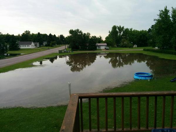
Standing water in Webster, from Landon @ssjnimma