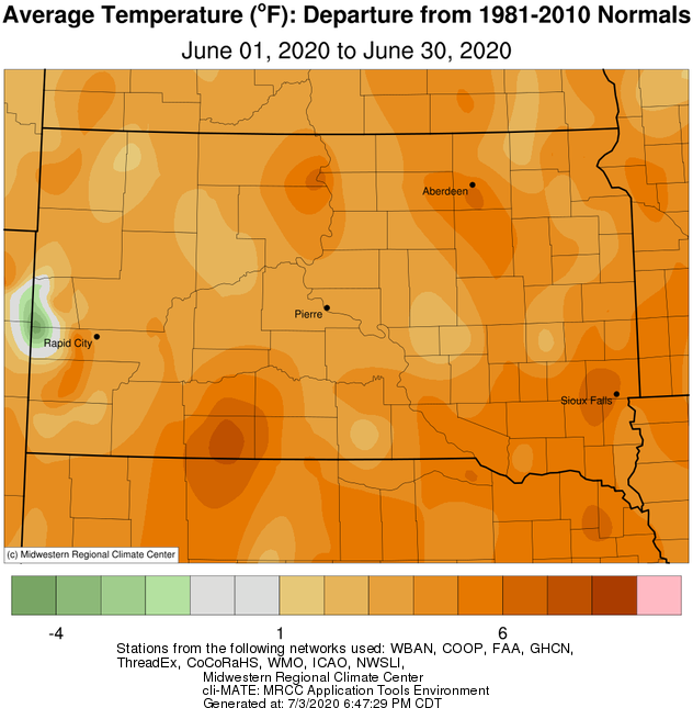
June 2020 finished well above normal across the board temperature-wise, anywhere from 2 to 7 degrees on a whole. A number of daily records were set this month including numerous record warm lows at Aberdeen, Watertown, Pierre and Sisseton ranging between 64 and 73 degrees from the 1st through the 17th, as well as a number of daily record warm highs: 95 F in Aberdeen on the 7th (95 in 1959), 94 F in Sisseton on the 1st (93 in 1940) and 99 F in Sisseton on the 7th (95 in 1959). Regarding the month as a whole, several locations recorded top-10 warm Junes on record: 9th place in Timber Lake with 70.3 F (76.7 in 1988), 7th place in Mobridge with 72.8 F (78.6 in 1911), 6th place in Wheaton with 71.6 F (75.4 in 1988), 5th place in Aberdeen with 72.5 F (79.1 in 1933) and 5th place in Sisseton with 71.7 F (75.4 in 1933).
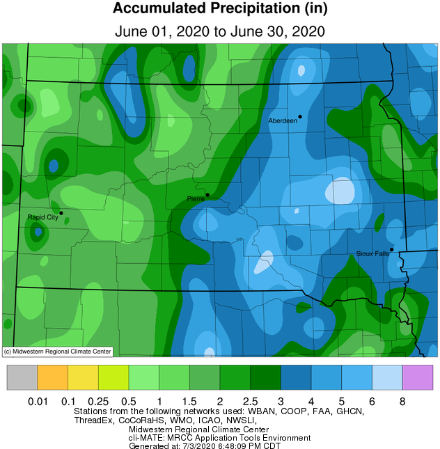
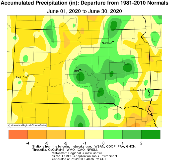
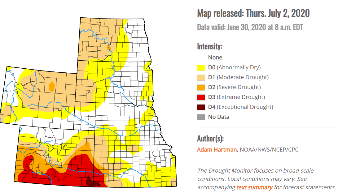
Numerous rounds of thunderstorms across the area made for lob-sided monthly precipitation totals. Generally speaking, north central South Dakota and eastern South Dakota finished the month below average, while portions of the James Valley and portions of central South Dakota finished above average. Moderate drought conditions have remained largely unchanged from the beginning of the month to the end, with a pocket near Corson County in North Dakota and also across west central Minnesota. Meanwhile, abnormally dry conditions have expanded to include more of east central South Dakota as well as portions of central/north central South Dakota. June 2020 finished as the 4th driest on record at Timber Lake with a total of 0.76” (0.54” in 1956). Just 0.22” of moisture had been recorded up until the 28th of the month.
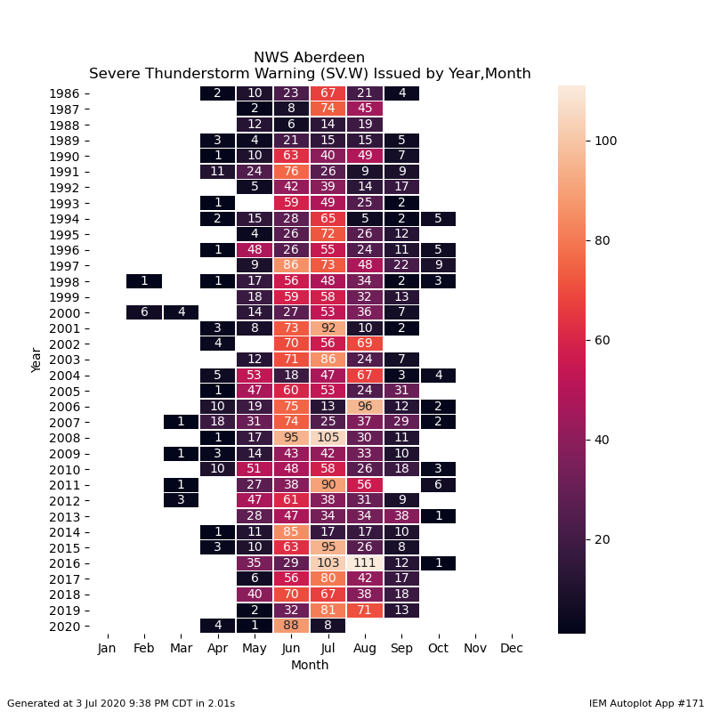
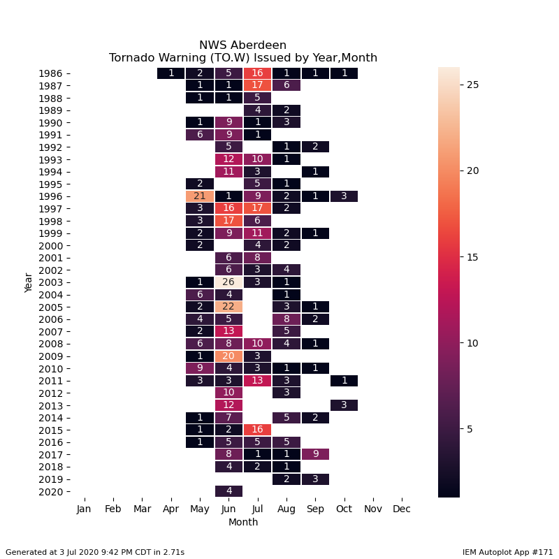
Thunderstorms became severe on several days this June, with the most significant and/or widespread events occurring on the 4th (https://www.weather.gov/abr/June42020SevereWinds), 6th and 7th (https://www.weather.gov/abr/June6_8_2020_SevereWx). The National Weather Service office in Aberdeen issued a total of 88 severe thunderstorm warnings across our forecast area this June, which is the second highest total since records began in 1986 (95 in 2008). An additional 4 tornado warnings were issued. A total of 42 severe/tornado warnings were issued on the 7th, which is the 3rd most on any single calendar day for our office since 1990 (the most, 44, were issued on Aug 10, 2016).
|
June 2020 |
||||
|
Temperature Data |
Aberdeen |
Sisseton |
Wheaton |
Watertown |
|
Warmest Temperature / Date |
98 / 1st |
99 / 7th |
98 / 7th |
93 / 1st, 7th |
|
Coldest Temperature / Date |
48 / 3rd |
51 / 22nd |
52 / 22nd |
51 / 3,5,11th |
|
Average High / Departure from Normal |
84.9 / +7.5 |
83.4 / +6.1 |
81.6 / +4.3 |
81.2 / +4.5 |
|
Average Low / Departure from Normal |
60.2 / +6.5 |
59.9 / +5.1 |
61.6 / +5.5 |
59.8 / +5.3 |
|
Monthly Average / Departure from Normal |
72.5 / +6.9 |
71.7 / +5.6 |
71.6 / +4.9 |
65.6 / +4.9 |
|
Precipitation Data |
|
|
|
|
|
Monthly Precipitation / Departure from Normal |
4.43 / +0.73 |
1.95 / -1.79 |
3.81 / -0.17 |
3.83 / +0.25 |
|
Most Precipitation in 24 hours / Date |
1.04 / 9th |
0.78 / 9th |
1.74 / 9th |
1.41 / 18th |
|
Monthly Snowfall / Departure from Normal |
N/A |
N/A |
N/A |
N/A |
|
Most Snow in 24 hours / Date |
N/A |
N/A |
N/A |
N/A |
|
Temperature Data |
Pierre |
Kennebec |
Mobridge |
Timber Lake |
|
Warmest Temperature / Date |
97 / 7th |
96 / 7th |
95 / 7,16th |
93 / 17,28th |
|
Coldest Temperature / Date |
49 / 19,23rd |
47 / 10th |
44 / 19th |
43 / 19th |
|
Average High / Departure from Normal |
83.6 / +3.6 |
86.0 / +4.1 |
86.2 / +8.4 |
84.1 / +5.6 |
|
Average Low / Departure from Normal |
58.9 / +3.5 |
59.7 / +3.9 |
59.4 / +5.6 |
56.5 / +2.9 |
|
Monthly Average / Departure from Normal |
71.2 / +3.5 |
73.2 / +4.4 |
72.8 / +7.0 |
70.6 / +4.5 |
|
Precipitation Data |
|
|
|
|
|
Monthly Precipitation / Departure from Normal |
2.14 / -1.43 |
4.47 / +1.12 |
1.80 / -1.36 |
0.73 / -2.57 |
|
Most Precipitation in 24 hours / Date |
0.81 / 7th |
1.36 / 9th |
0.74 / 28th |
1.89 / 24th |
|
Monthly Snowfall / Departure from Normal |
N/A |
N/A |
N/A |
N/A |
|
Most Snow in 24 hours / Date |
N/A |
N/A |
N/A |
N/A |
June 2020 temperature departure from normal, from the Midwestern Regional Climate Center
June 2020 precipitation totals (left) and departures from normal (right), from the Midwestern Regional Climate Center
US Drought Monitor as of July 2, 2020
The number of Severe Thunderstorm Warnings (left) and Tornado Warnings (right) issued by the NWS in Aberdeen by month since 1986. Information from the Iowa Environmental Mesonet.