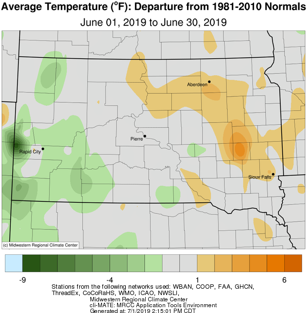
June 2019 featured near normal temperatures on a whole across the area, but it finished on a hot note. Widespread highs in the 90s were observed on both the 28th and 29th, and Pierre, Murdo and Gann Valley reached the century mark on the 29th. Unfortunately, this heat combined with a very muggy air mass of 70-80° dewpoints on the 29th, and heat index values soared well into the 100s as a result. Some heat index values include: 106° in Watertown, 109° in Aberdeen and Pierre, and 114° in Mobridge. Not much relief arrived with nightfall either. Daily record warm low temperatures were tied on the 29th at both Watertown and Sisseton with 72° (also in 1931) and 70° (also in 2018) respectively.
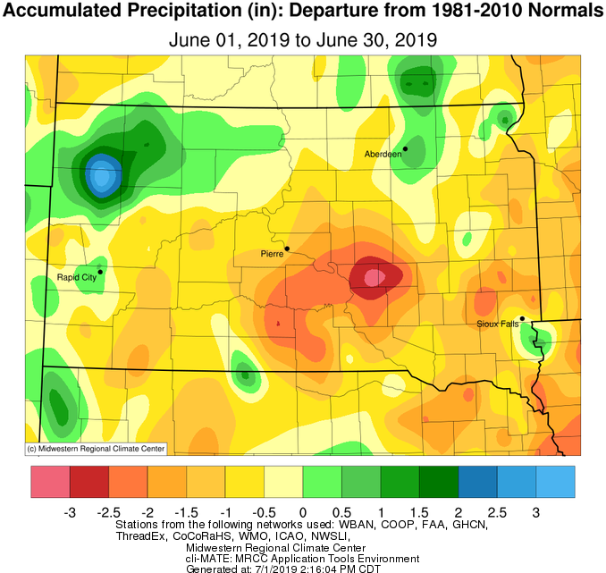
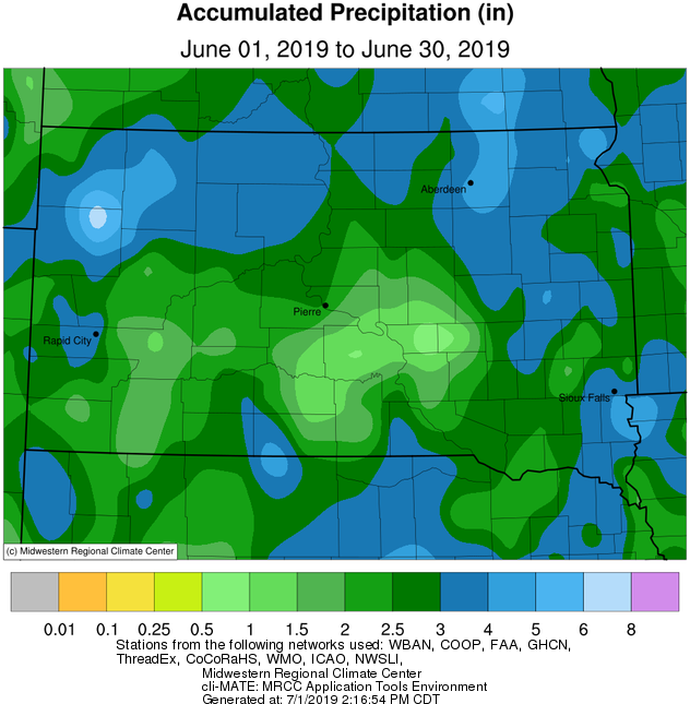
This June finished between 1 to 2 inches above and below normal for precipitation as well, depending on where you were. While Aberdeen picked up 4.7” of moisture, Kennebec had just 0.84”. These discrepancies happen during the summer months, due to the often scattered nature of thunderstorms. And indeed, several days this June featured afternoon, generally disorganized, thunderstorm development. Only one daily rainfall record was set at any of our Automated Surface Observation System (ASOS) sites (Aberdeen, Sisseton, Watertown, Pierre and Mobridge): 2.06” at Mobridge on the 19th (1.09” in 1951).
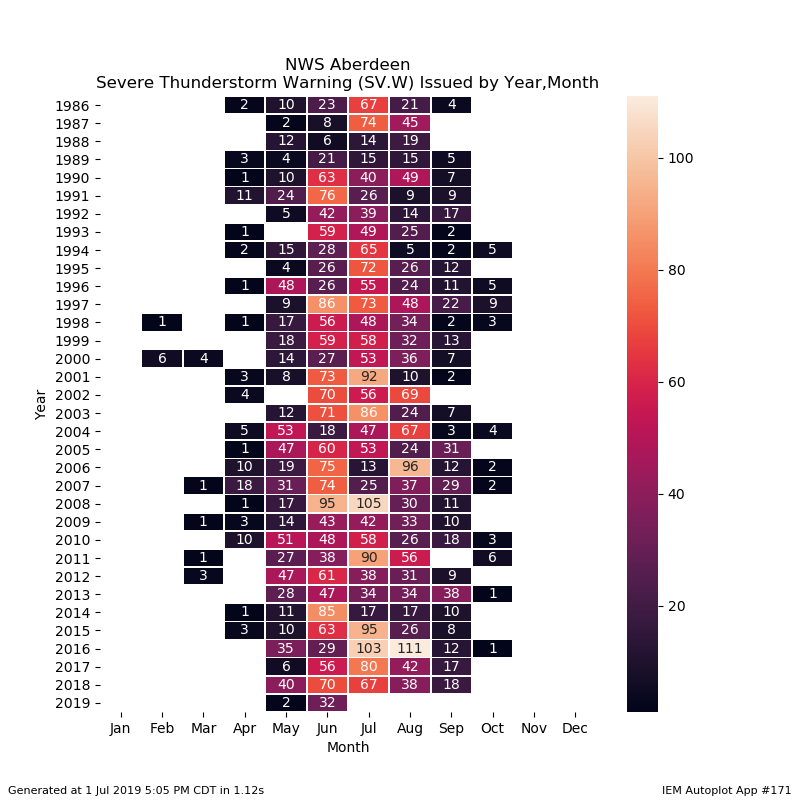
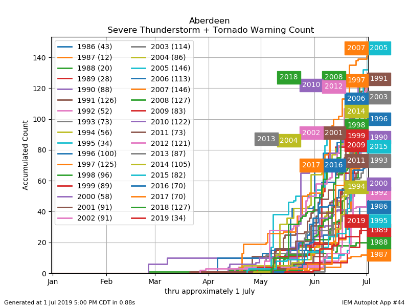
Despite a couple overnight thunderstorm squall lines late in the month, and a few other relatively isolated events, severe weather was remarkably absent in June (the climatologically most active month for South Dakota and Minnesota). This, mind you, on the heels of a similarly inactive May. Year-to-date, NWS Aberdeen has only issued 34 Severe Thunderstorm/Tornado warnings. This ranks in the bottom 5 for most warnings since 1986. Despite the relative inactivity, a rare anticyclonic tornado developed just north of Estelline, SD. Only about one in 700-1000 tornadoes rotate anticyclonically/clockwise. More information here: https://www.weather.gov/abr/2019_June15_Tornado.
|
June 2019 |
||||
|
Temperature Data |
Aberdeen |
Sisseton |
Wheaton |
Watertown |
|
Warmest Temperature / Date |
94°/ 29th |
93°/ 7th |
92°/ 7th |
93°/ 29th |
|
Coldest Temperature / Date |
44°/ 10th |
35°/ 12, 13th |
45°/ 12th |
45°/ 12, 13th |
|
Average High / Departure from Normal |
80.9°/ +3.5° |
78.8°/ +1.5° |
77.6°/ +0.3° |
77.8°/ +1.1° |
|
Average Low / Departure from Normal |
55.8°/ +2.1° |
56.3°/ +1.5° |
57.8°/ +1.7° |
55.9°/ +1.4° |
|
Monthly Average / Departure from Normal |
68.3°/ +2.7° |
67.5°/ +1.4° |
67.7°/ +1.0° |
66.8°/ +1.2° |
|
Precipitation Data |
||||
|
Monthly Precipitation / Departure from Normal |
4.70”/ +1.00” |
2.56”/ -1.18” |
2.99”/ +0.99” |
2.04”/ -1.54” |
|
Most Precipitation in 24 hours / Date |
1.37”/ 21st |
0.85”/ 20th |
0.52”/ 20th |
0.59”/22nd |
|
Monthly Snowfall / Departure from Normal |
N/A |
N/A |
N/A |
N/A |
|
Most Snow in 24 hours / Date |
N/A |
N/A |
N/A |
N/A |
|
Temperature Data |
Pierre |
Kennebec |
Mobridge |
Timber Lake |
|
Warmest Temperature / Date |
100°/ 29th |
101°/ 29th |
95°/ 29th |
93°/ 29, 30th |
|
Coldest Temperature / Date |
43°/ 10th |
25°/ 2nd |
43°/ 10, 23rd |
41°/ 1st |
|
Average High / Departure from Normal |
80.0°/ +0.0° |
82.4°/ +0.5° |
79.9°/ +2.1° |
79.9°/ +1.4° |
|
Average Low / Departure from Normal |
54.6°/ -0.8° |
55.3°/ -0.5° |
55.1°/ +1.3° |
53.6°/ +0.0° |
|
Monthly Average / Departure from Normal |
67.3°/ -0.4° |
68.9°/ +0.1° |
67.5°/ +1.7° |
66.8°/ +0.7° |
|
Precipitation Data |
||||
|
Monthly Precipitation / Departure from Normal |
2.25”/ -1.32” |
0.84”/ -2.51” |
3.32”/ +0.16” |
3.32”/ +0.02” |
|
Most Precipitation in 24 hours / Date |
1.03”/ 19th |
0.18”/ 21st |
2.06”/ 19th |
1.69”/ 19th |
|
Monthly Snowfall / Departure from Normal |
N/A |
N/A |
N/A |
N/A |
|
Most Snow in 24 hours / Date |
N/A |
N/A |
N/A |
N/A |
Departures from normal of average temperature this June, from the Midwestern Regional Climate Center
Departures from normal of precipitation this June, from the Midwestern Regional Climate Center. Note, the precipitation that fell on the evening of June 30th into the morning of July 1st is not included.
Precipitation totals this June, from the Midwestern Regional Climate Center. Note, the precipitation that fell on the evening of June 30th into the morning of July 1st is not included.
Plot of number of severe weather warnings issued by the NWS in Aberdeen for 2019 and every other year since 1986, to highlight the relative severe weather inactivity so far this year. Data from the ISU Iowa Environmental Mesonet
Plot of number of severe weather warnings issued by the NWS in Aberdeen for 2019 and every other year since 1986, by month, to highlight the relative severe weather inactivity so far this year. Data from the ISU Iowa Environmental Mesonet