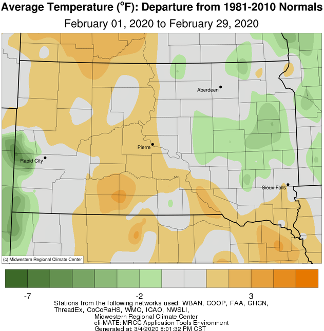
February 2020 finished near average temperature-wise; generally slightly above average across central SD and slightly below across eastern SD and west central MN. The most significant cold snap of the season occurred during the middle of the month (Pierre tied a daily record low temp of -16 F on the 13th (2007)), but there were several periods of mild weather as well. Areas with deeper snow pack, particularly following the heavy snow on Feb 8th and 9th, experienced colder temperatures on average.
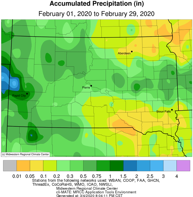
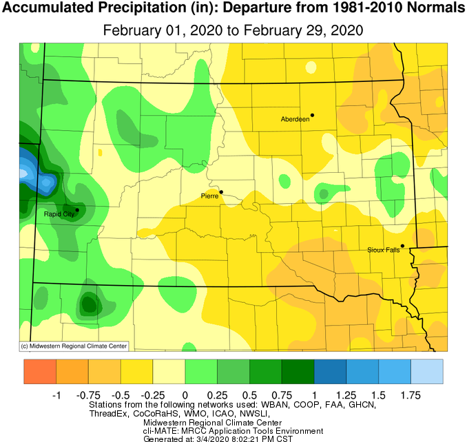
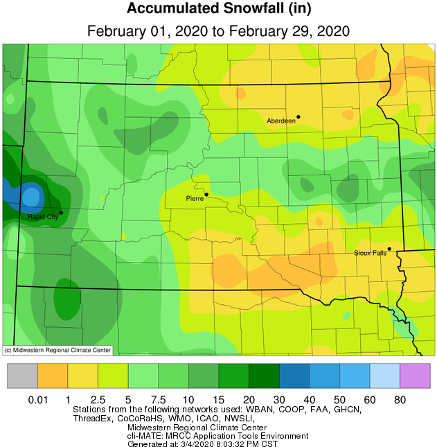
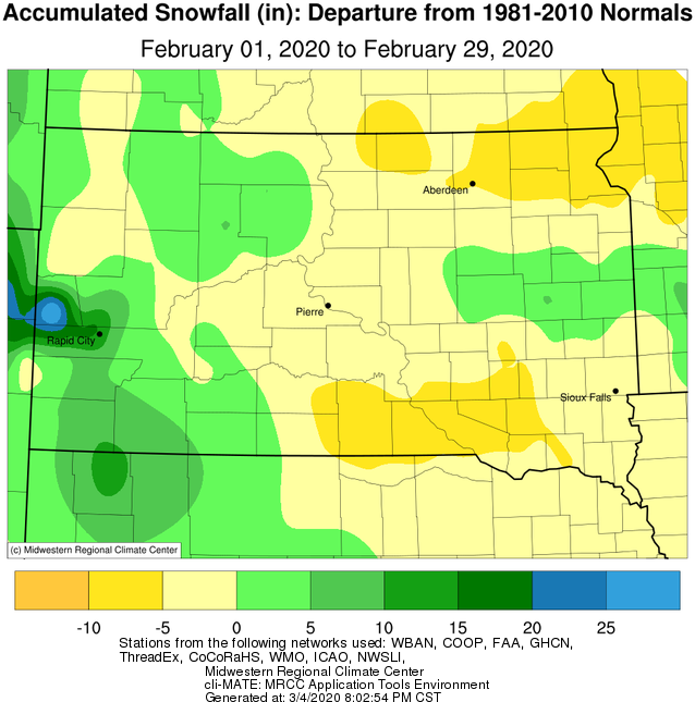
Precipitation and snow-wise, south central SD, northeastern SD and west central MN finished the month below average wile portions of north central and east central SD finished slightly above average. The most widespread snow event occurred on the 8th-9th, when a relatively narrow band of heavy snow blanketed central portions of South Dakota. Visit https://www.weather.gov/abr/SummaryOfFeb8-9HeavySnowANDFeb12Blizzard for more information. The other significant event of the month took place on the 12th, when generally light snow combined with strong winds to produce blizzard conditions. See the link above for more information. That said, this February was much drier than last February, February 2019. For comparison, Watertown had 11.2” less snow, Pierre had 13.8” less snow, Aberdeen and Sisseton had 17.5” less snow, and Mobridge had a staggering 33.9” less snow.
|
February 2020 |
||||
|
Temperature Data |
Aberdeen |
Sisseton |
Wheaton |
Watertown |
|
Warmest Temperature / Date |
46 / 2nd |
47 / 1st |
48 / 1st |
43 / 2nd |
|
Coldest Temperature / Date |
-21 / 13th |
-14 / 12, 13th |
-17 / 13th |
-22 / 23rd |
|
Average High / Departure from Normal |
29.2 / +1.3 |
28.3 / +0.8 |
27.0 / +1.9 |
25.9 / -1.4 |
|
Average Low / Departure from Normal |
7.4 / +0.2 |
9.4 / +0.7 |
8.5 / +3.2 |
4.3 / -3.5 |
|
Monthly Average / Departure from Normal |
18.3 / +0.7 |
18.9 / +0.8 |
17.8 / +2.6 |
15.1 / -2.4 |
|
Precipitation Data |
|
|
|
|
|
Monthly Precipitation / Departure from Normal |
0.11 / -0.44 |
0.15 / -0.28 |
0.02 / -0.59 |
0.43 / -0.13 |
|
Most Precipitation in 24 hours / Date |
0.06 / 12th |
0.06 / 16th |
0.02 / 17th |
0.21 / 9th |
|
Monthly Snowfall / Departure from Normal |
1.8 / -5.0 |
1.7 / -6.7 |
0.3 / -7.8 |
6.9 / -0.5 |
|
Most Snow in 24 hours / Date |
1.0 / 12th |
0.9 / 12th |
0.3 / 17th |
3.3 / 9th |
|
Temperature Data |
Pierre |
Kennebec |
Mobridge |
Timber Lake |
|
Warmest Temperature / Date |
60 / 29th |
61 / 1st |
51 / 1st |
49 / 29th |
|
Coldest Temperature / Date |
-16 / 13th |
-14 / 13th |
-18 / 13th |
-19 / 13th |
|
Average High / Departure from Normal |
36.9 / +2.0 |
37.5 / +0.6 |
33.7 / +2.5 |
32.1 / -0.3 |
|
Average Low / Departure from Normal |
14.9 / +1.1 |
15.7 / +1.6 |
11.5 / +1.4 |
11.5 / -0.6 |
|
Monthly Average / Departure from Normal |
25.9 / +1.6 |
26.6 / +1.1 |
22.6 / +1.9 |
21.8 / -0.5 |
|
Precipitation Data |
|
|
|
|
|
Monthly Precipitation / Departure from Normal |
0.51 / -0.08 |
0.14 / -0.34 |
0.46 / +0.02 |
0.67 / +0.08 |
|
Most Precipitation in 24 hours / Date |
0.20 / 9th |
0.07 / 9th |
0.29 / 24th |
0.22 / 25th |
|
Monthly Snowfall / Departure from Normal |
5.2 / -0.7 |
2.0 / -4.1 |
5.1 / -0.8 |
12.7 / +6.0 |
|
Most Snow in 24 hours / Date |
2.2 / 9th |
0.7 / 9th, 25th |
2.5 / 24th |
3.8 / 24th |
Temperature departures over the course of February 2020, courtesy of the Midwestern Regional Climate Center.
Precipitation totals (left) and departures (right) over the course of February 2020, courtesy of the Midwestern Regional Climate Center.
Snowfall totals (left) and departures (right) over the course of February 2020, courtesy of the Midwestern Regional Climate Center.
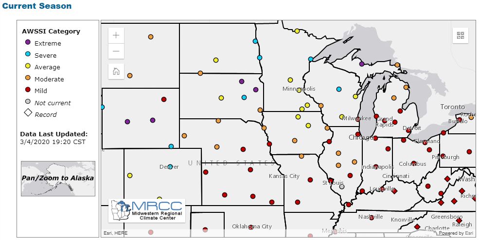
The Accumulated Winter Season Severity Index as of March 4th shows a wide range of experiences across South Dakota, from a Moderate to an Extreme winter. Visit https://mrcc.illinois.edu/research/awssi/indexAwssi.jsp for more.
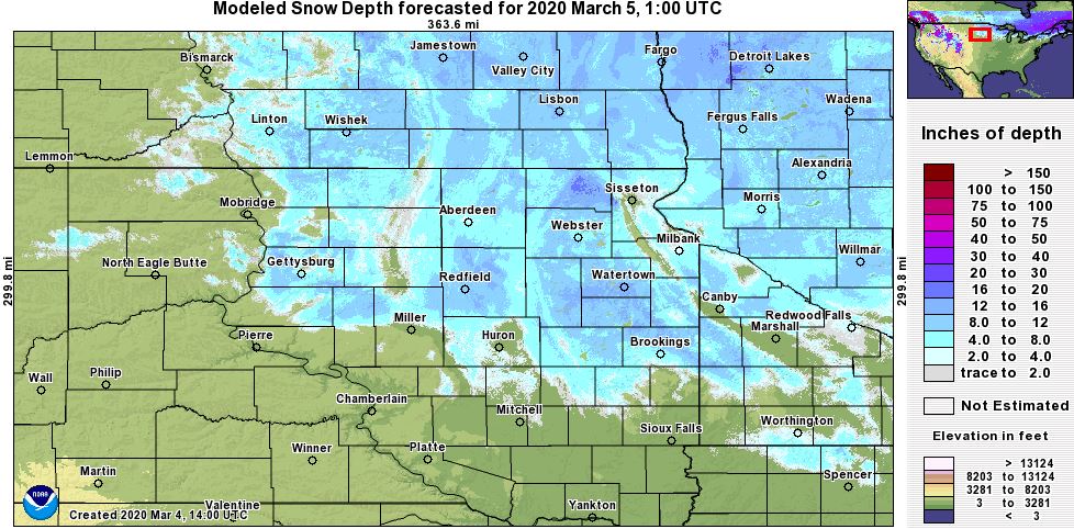
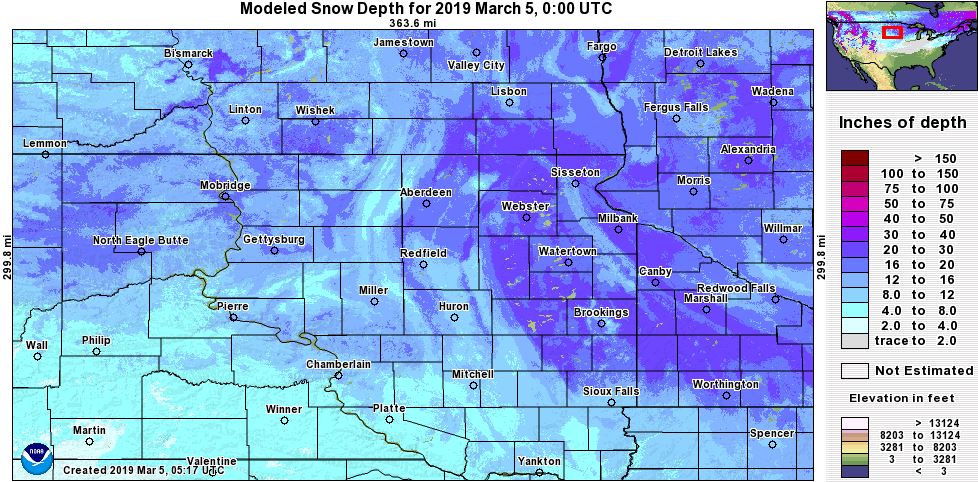
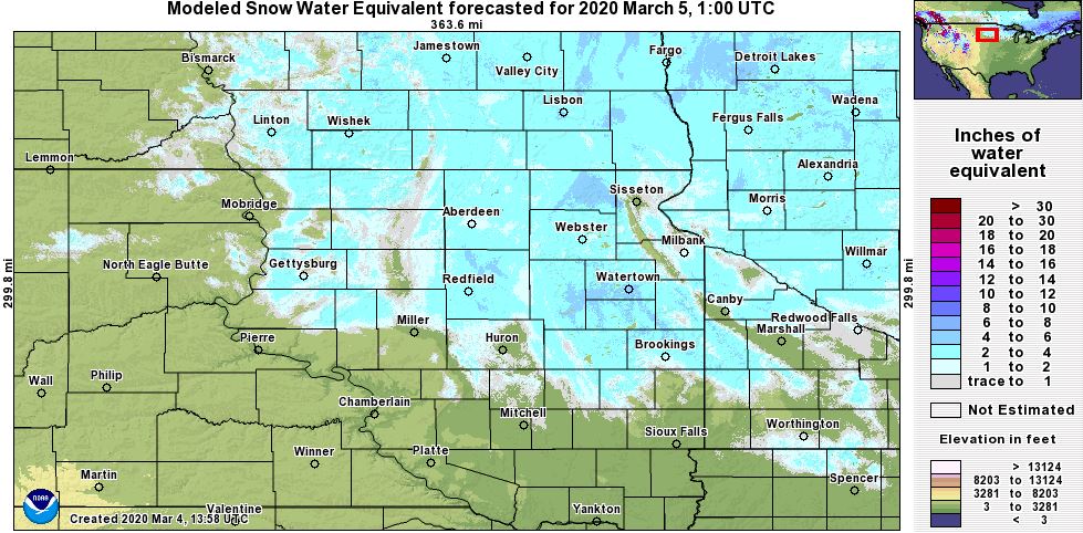
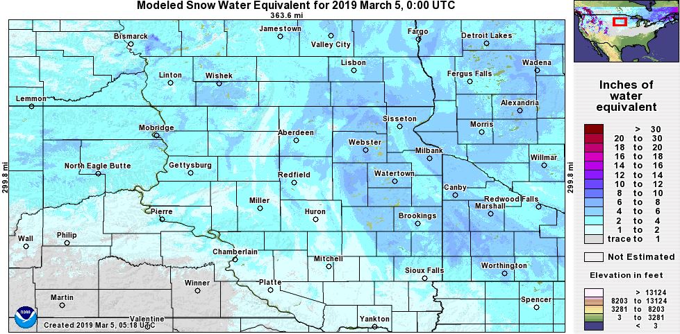
Below is a comparison between snow depth (first two images) and snow water equivalent (second two images) of March 4th, 2020 and March 4th, 2019 across the area. A more substantial base of snow, both in terms of coverage and depth, was in place this time last year. However, the snow season is far from over. Data from NOHRSC at https://bit.ly/2Tpc80z
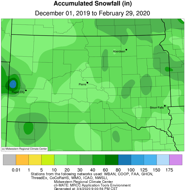
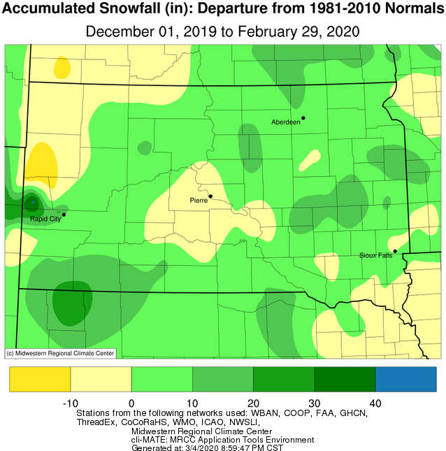
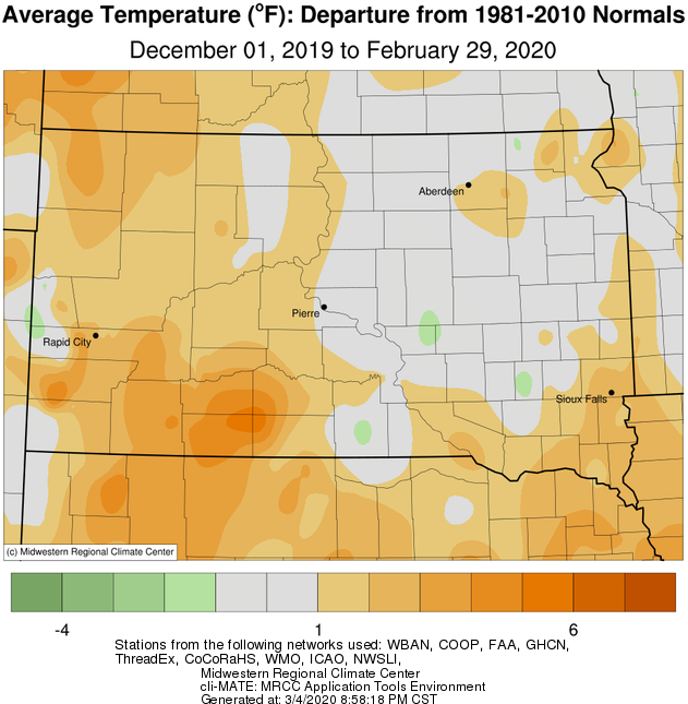
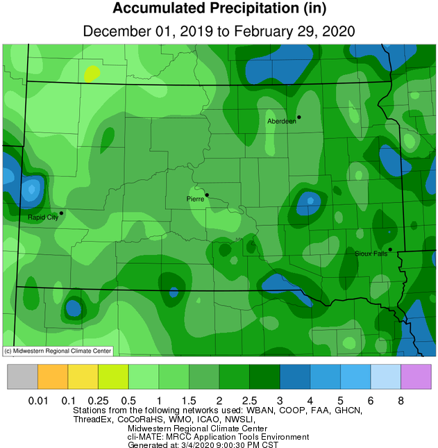
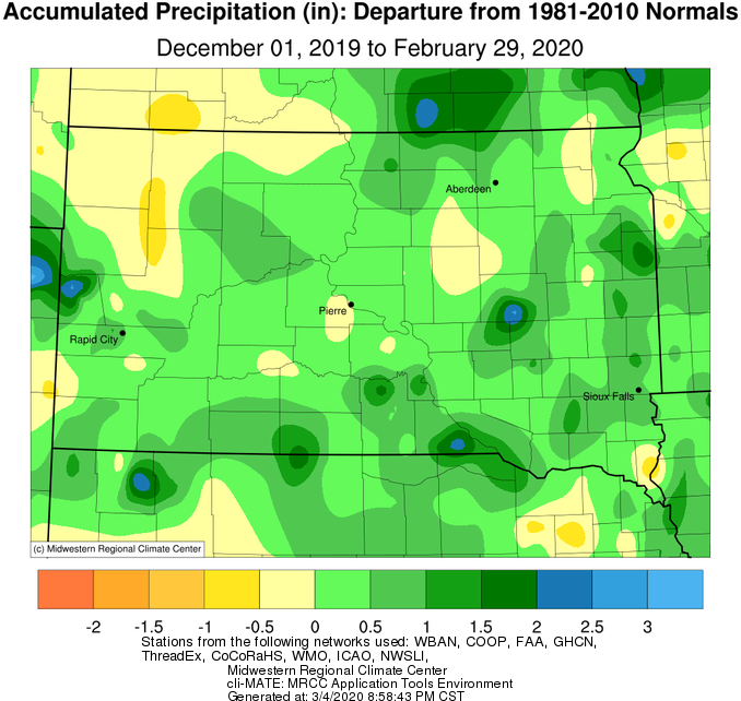
Winter 2019-2020 (Dec, Jan and Feb) finished near or slightly above average across the area, and most finished above average in terms of precipitation and snowfall. View the graphics from the Midwestern Regional Climate Center below for more.
Temperature departures over the course of the 2019-2020 winter.
Precipitation totals (left) and departures (right) over the course of the 2019-2020 winter.
Snowfall totals (left) and departures (right) over the course of the 2019-2020 winter.