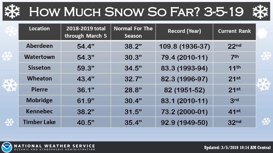
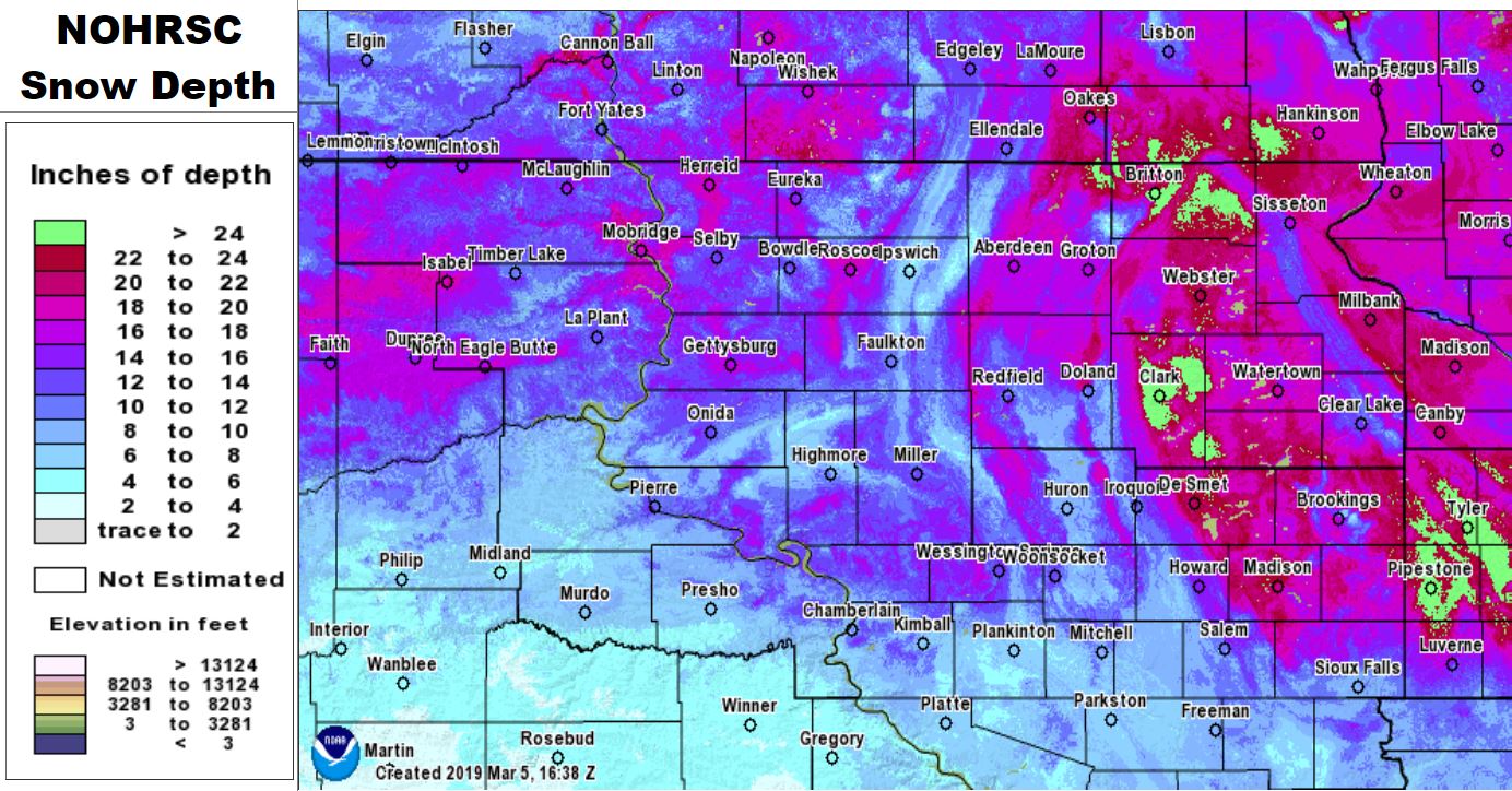
Aside from the relatively localized banded snow event on the 6th in which Mobridge broke a daily snowfall record of 7.6” (https://www.weather.gov/abr/February6thand7thBandedsnowandBlizzardSummary), there were no significant heavy snow storms. Instead, frequent fluffy 2-5” snow events added up substantially. This February will go down as the 6th snowiest on record in Aberdeen, 3rd snowiest (tie) in Pierre, 7th in Watertown, 1st in Mobridge (the preliminary total of 39” this February breaks the record for most snow during *any* month on record, previously held by March of 1966 with 36.3”), 6th in Wheaton, and 3rd in Timber Lake. All of this snow filled most ditches, and its generally fluffy nature made it very susceptible to blowing/drifting. As a result, roads conditions often deteriorated whenever the wind blew. Blizzard warnings were issued for the 7th and 25th across portions of northeastern South Dakota and west central Minnesota, as strong winds greatly reduced visibilities. Temperatures failed to reach the melting point for many this month, and new snow continued to exceed what was able to settle. Thus, snow depths continued to rise across the area. As of the 28th, Andover and Westport’s snow depth was reported at 30”, Clark was at 37”, and Britton 40”.
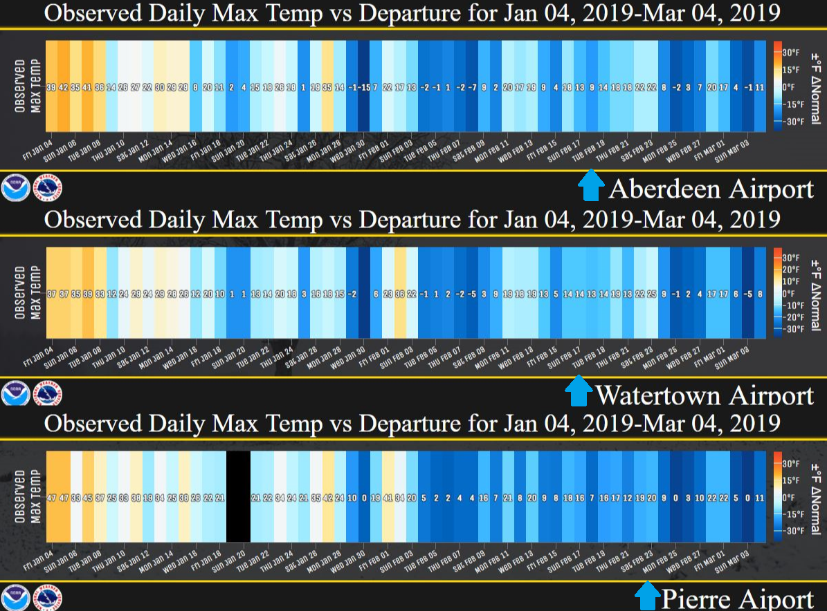
Substantial snow depths and consistent new snow cover allowed for the development of record-territory cold temperatures. Aberdeen recorded their 3rd coldest February on record, it was Pierre’s 2nd coldest, 4th in Watertown, 2nd in Mobridge, 2nd in Sisseton, 1st in Wheaton, 4th (tie) in Kennebec, and 2nd in Timber Lake. Additionally, this was the first February on record where the temperature failed to rise above 22 degrees in Aberdeen and 25 degrees in Sisseton. For Aberdeen, this will be one of only 4 Februaries on record to never breach the melting point/32 degrees F. Looking back further, as of this writing on March 5th, the last time the temperature has reached the melting point in Aberdeen was 37 days ago on January 27th (35 degrees) granted it was only for about 15 minutes as a narrow warm surge of air brushed town out ahead of a potent blizzard. This was also the last time Aberdeen’s overall averaged daily temperature was above normal – the record streak of consecutive days below normal out of any time of the year was 50 days, which took place from Jan 11 – Feb 29th in 1936. If not for those 15 minutes on Jan 27th, 2019, Aberdeen’s current streak would be at 47 days. The last time the temp has been at the melting point in Pierre and Watertown was Feb 2nd. Regarding low temperatures, Aberdeen broke a record for number of nights with a low temperature below 0 degrees with 24 (23 in 1936 and 1917), Pierre, Watertown, Mobridge, Wheaton and Timber Lake ranked 2nd with anywhere from 19 to 23 nights below zero this February.
|
February 2019 |
||||
|
Temperature Data |
Aberdeen |
Sisseton |
Wheaton |
Watertown |
|
Warmest Temperature / Date |
22°/ 1,22,23rd |
25°/ 23rd |
28°/ 23rd |
36°/ 2nd |
|
Coldest Temperature / Date |
-23°/ 8th |
-19°/ 8th |
-20°/ 1st |
-23°/ 8th |
|
Average High / Departure from Normal |
10.4°/ -17.5° |
9.7°/ -17.8° |
10.6°/ -14.5° |
11.7°/ -15.6° |
|
Average Low / Departure from Normal |
-7.1°/ -14.3° |
-4.8°/ -13.5° |
-5.0°/ -10.3° |
-4.9°/ -12.7° |
|
Monthly Average / Departure from Normal |
1.7°/ -15.9° |
2.5°/ -15.6° |
2.8°/ -12.4° |
3.4°/ -14.1° |
|
Precipitation Data |
||||
|
Monthly Precipitation / Departure from Normal |
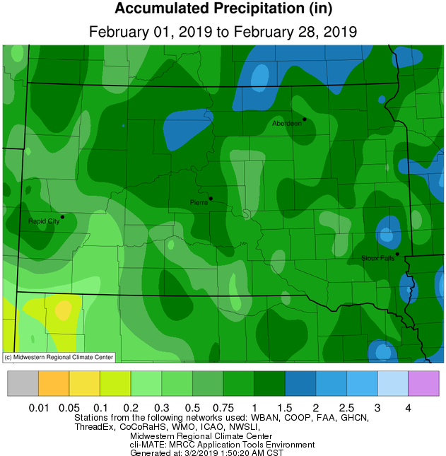
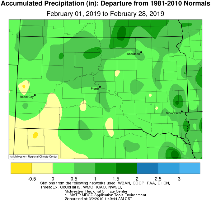
1.24”/+0.69” |
1.48”/+1.05” |
1.11”/+0.5” |
1.01”/+0.45” |
|
Most Precipitation in 24 hours / Date |
0.30”/ 20th |
0.45”/ 20th |
0.23”/ 3, 20th |
0.36”/20th |
|
Monthly Snowfall / Departure from Normal |
19.3” / +12.5” |
19.4” / +11” |
15.7” / +7.6” |
18.1”/ +10.7” |
|
Most Snow in 24 hours / Date |
3.6” / 20th |
4.0” / 20th |
2.8” / 11th |
5.3” / 20th |
|
Temperature Data |
Pierre |
Kennebec |
Mobridge |
Timber Lake |
|
Warmest Temperature / Date |
41°/ 1st |
52°/ 2nd |
33°/ 1st |
42°/ 1st |
|
Coldest Temperature / Date |
-18°/ 8th |
-18°/ 8, 19th |
-29°/ 8th |
-26°/ 8th |
|
Average High / Departure from Normal |
13.2°/ -21.7° |
17.8°/ -19.1° |
11.2°/ -20.0° |
9.8°/ -22.6° |
|
Average Low / Departure from Normal |
-2.4°/ -16.2° |
0.2°/ -13.9° |
-5.3°/ -15.4° |
-6.6°/ -18.7° |
|
Monthly Average / Departure from Normal |
5.4°/ -18.9° |
9.2°/ -16.3° |
2.9°/ -17.8° |
1.6°/ -20.7° |
|
Precipitation Data |
||||
|
Monthly Precipitation / Departure from Normal |
1.47”/ +0.88” |
1.02”/+0.54” |
1.76”/+1.32” |
1.61”/+1.02” |
|
Most Precipitation in 24 hours / Date |
0.29”/ 22nd |
0.32”/ 22nd |
0.33”/6th |
0.44”/ 16th |
|
Monthly Snowfall / Departure from Normal |
19.0 / +13.1” |
15.5” / +9.4” |
39.0”/ +33.1” |
21.8”/ +15.1” |
|
Most Snow in 24 hours / Date |
3.3”/ 22nd |
3.5” / 17, 22 |
7.6” / 6th |
4.6” / 16th |
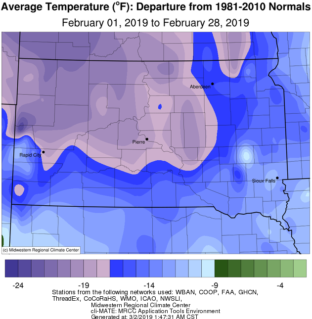
February 2019 temperature departures, courtesy of the Midwestern Regional Climate Center
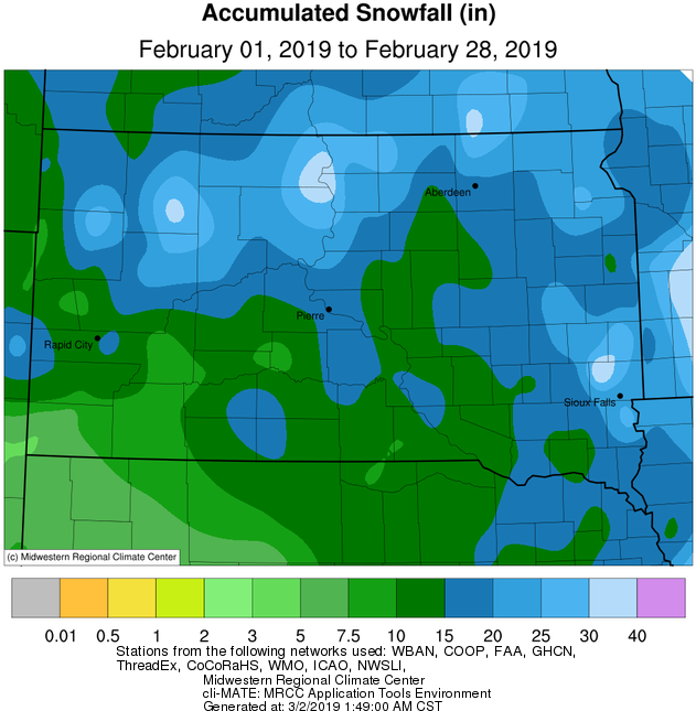
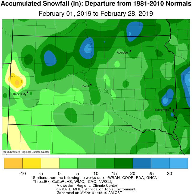
February 2019 snow totals (left) and departures (right), courtesy of the Midwestern Regional Climate Center
February 2019 precipitation totals (left) and departures (right), courtesy of the Midwestern Regional Climate Center
Daily high temperatures (values) and departures (shades of blue and orange indicating magnitude) over the past 60 days at Aberdeen, Watertown and Pierre
Total snow this season through March 5th, 2019, etc.
Approximate snow depth as of March 4th, 2019
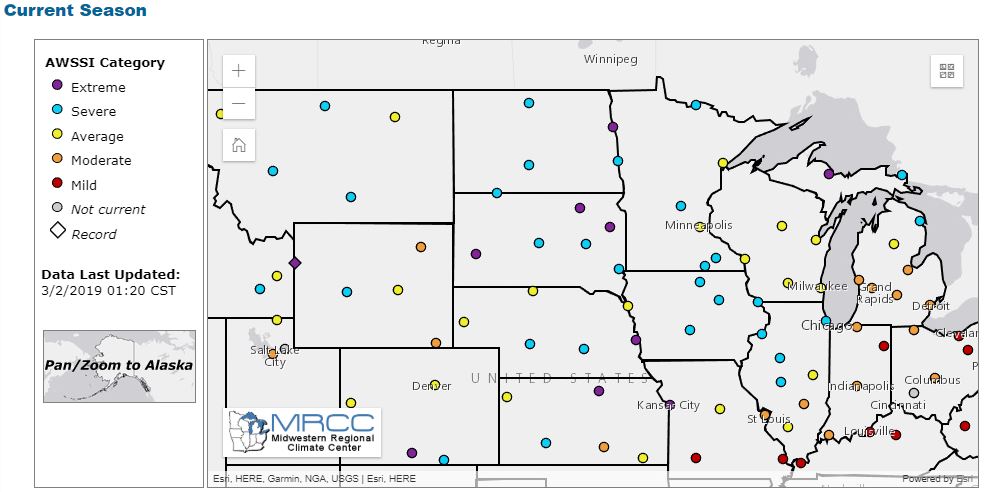
The Accumulated Winter Season Severity Index (AWSSI) as of March 2nd, courtesy of the Midwestern Regional Climate Center. Click on each point to view a location-specific graph of this index through the season.