Overview
|
A very slow moving and stacked low pressure system pushed over the Dakotas late Friday, August 4th through Sunday, August 6th as it continued its track southeast. This low had an abundance of moisture as weather models' Precipitable Water (PWAT) values indicated nearly two inches of moisture in the atmosphere, supporting the threat for heavy rain. Surface dew point values were well in the mid to upper 60s to lower 70s during this time frame as well, making it very humid. The result was widespread rainfall that occurred over the forecast area, which was very welcoming and much needed! Rainfall amounts ranged from an inch in Clark, SD to over nine inches near Rockham, SD! There was some minor flooding with reports of secondary roads under water in Hand and Spink Counties. |
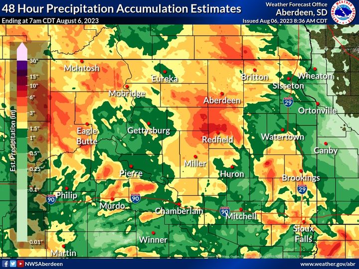 48 hour precipitation accumulation estimates. August 4th-August 6th, 2023 |
Radar
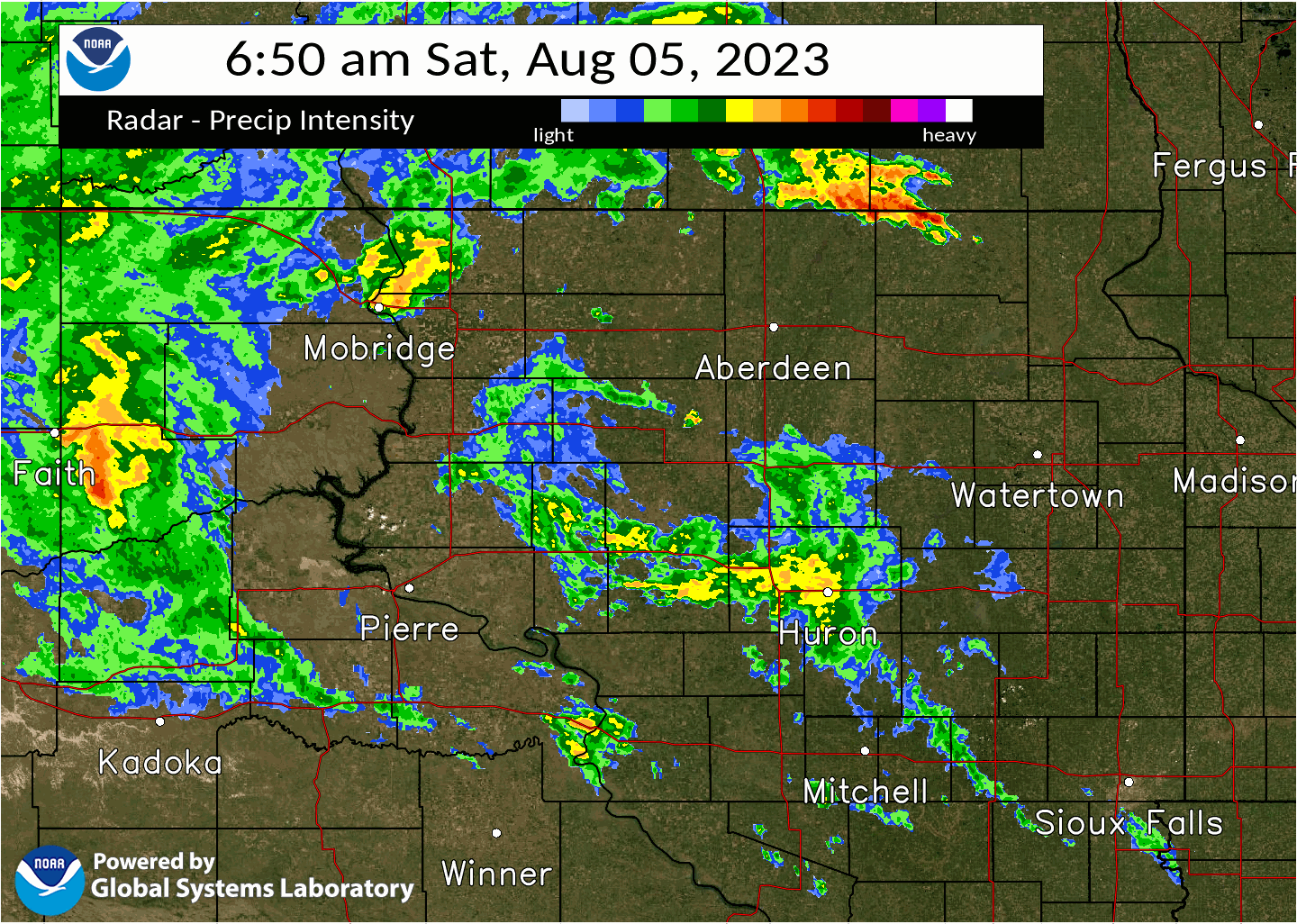 |
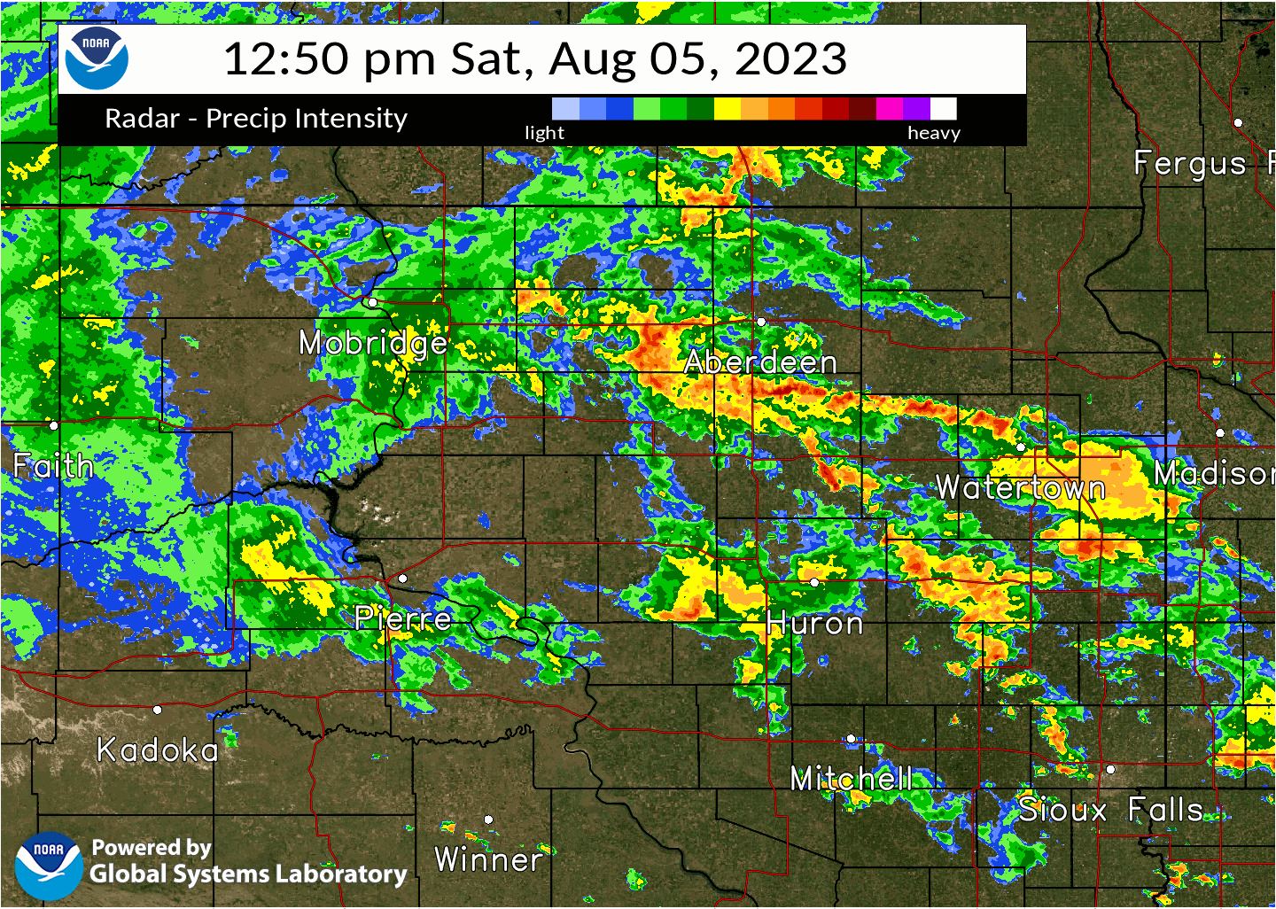 |
| Radar imagery from 6:50am -12:50pm Saturday 8/5/23 | Radar imagery from 12:50pm-5:50pm Saturday 8/5/23 |
Rain Reports
...PRECIPITATION REPORTS...

The precipitation reports are 2 day or 48 hour totals ending at
the time listed and only include values over 1 inch.

Location                     Amount    Time/Date       Provider
2 SSE Rockham                9.40 in   0942 AM 08/06   Public
3 SSE Burdette               8.26 in   1038 AM 08/06   Public
Zell                         8.10 in   1031 AM 08/06   Public
Cottonwood Lake              7.96 in   1116 AM 08/06   Mesonet
5 ENE Frankfort              7.47 in   1111 AM 08/06   Mesonet
Presho 12 NNE                7.40 in   0700 AM 08/06   COCORAHS
5 NE Zell                    7.10 in   1124 AM 08/06   Public
5 N Zell                     6.80 in   1045 AM 08/06   Public
4 SW Athol                   6.75 in   0856 AM 08/06   Public
5 N Rockham                  6.69 in   1028 AM 08/06   Mesonet
2 NNE Mansfield              6.31 in   1037 AM 08/06   Trained Spotter
1 N Redfield                 6.20 in   0800 AM 08/06   Broadcast Media
5 NNW Glencross              6.00 in   1135 AM 08/06   Public
Hayes 7 ESE                  5.41 in   0800 AM 08/06   COCORAHS
Hecla 7 WNW                  5.38 in   0800 AM 08/06   COCORAHS
Chelsea 3.8 W                5.37 in   0700 AM 08/06   COCORAHS
Vivian 7 NNE                 5.32 in   0700 AM 08/06   COCORAHS
Vivian 13 N                  4.83 in   1059 AM 08/06   RAWS
Ashton 1 NE                  4.83 in   1145 AM 08/06   COOP
Cravens Corner 6 SE          4.72 in   0800 AM 08/06   COCORAHS
Stratford                    4.70 in   1009 AM 08/06   Public
Warner                       4.50 in   0914 AM 08/06   Public
Mellette                     4.25 in   1109 AM 08/06   Mesonet
Roscoe 6 W                   4.23 in   0720 AM 08/06   COCORAHS
Conde                        4.10 in   0907 AM 08/06   Public
Vivian 4 N                   4.03 in   0716 AM 08/06   COCORAHS
Mellette                     3.98 in   1150 AM 08/06   CWOP
Presho 7.6 N                 3.96 in   0800 AM 08/06   COCORAHS
Bullhead 10 S                3.82 in   1106 AM 08/06   RAWS
Faulkton 1 NW                3.81 in   0800 AM 08/06   COOP
Timber Lake 6.6 E            3.78 in   0800 AM 08/06   COCORAHS
Hecla 5 NE                   3.77 in   0700 AM 08/06   UCOOP
4 E Brentwood Colony         3.70 in   0955 AM 08/06   Public
Roscoe                       3.60 in   0710 AM 08/06   COOP
Miller 7.2 NW                3.40 in   0846 AM 08/06   COCORAHS
Aberdeen 1 SSW               3.34 in   0607 AM 08/06   COCORAHS
Gann Valley 3 NNE            3.28 in   0740 AM 08/06   COOP
Danforth 5 E                 3.19 in   1141 AM 08/06   RAWS
Aberdeen Rgnl AP             3.19 in   1145 AM 08/06   ASOS
Doland 2 S                   3.18 in   0800 AM 08/06   UCOOP
Aberdeen 3 E                 3.10 in   0600 AM 08/06   COOP
Aberdeen 1.0 NNE             3.01 in   0700 AM 08/06   COCORAHS
Faulkton 3.8 W               2.90 in   0700 AM 08/06   COCORAHS
Murdo                        2.90 in   0900 AM 08/06   COOP
Aberdeen 1 NNE               2.89 in   0800 AM 08/06   COCORAHS
Aberdeen 0.6 NNE             2.86 in   0900 AM 08/06   COCORAHS
Westport 2 NW                2.83 in   0630 AM 08/06   COOP
1 SSW Redfield               2.82 in   1115 AM 08/06   Mesonet
Aberdeen 1 WSW               2.80 in   0700 AM 08/06   COCORAHS
Isabel 9.5 NE                2.80 in   0800 AM 08/06   COCORAHS
Wessington 7.0 SW            2.77 in   0738 AM 08/06   COCORAHS
Aberdeen                     2.76 in   1147 AM 08/06   CWOP
Aberdeen 1 ESE               2.72 in   0600 AM 08/06   COCORAHS
Frederick 8.4 SW             2.70 in   0700 AM 08/06   COCORAHS
Reliance 4 ENE               2.70 in   0800 AM 08/06   COCORAHS
Groton                       2.70 in   1145 AM 08/06   CWOP
Harrold 4 ESE                2.61 in   0800 AM 08/06   COCORAHS
Kennebec 8 SSW               2.60 in   0700 AM 08/06   COCORAHS
Okaton 3 NW                  2.57 in   0730 AM 08/06   COCORAHS
Estelline 7.7 WSW            2.53 in   0800 AM 08/06   COCORAHS
Bear Creek                   2.48 in   1052 AM 08/06   RAWS
Aberdeen 9 NW                2.46 in   1145 AM 08/06   CWOP
Aberdeen 5.5 NNW             2.44 in   0700 AM 08/06   COCORAHS
6 NE Roscoe                  2.42 in   0800 AM 08/06   COCORAHS
Aberdeen 7.5 NNE             2.38 in   0700 AM 08/06   COCORAHS
Hoven 2 N                    2.37 in   0900 AM 08/06   COCORAHS
Hayti 0.1 WNW                2.31 in   0800 AM 08/06   COCORAHS
Castlewood                   2.31 in   0800 AM 08/06   COOP
Pierre 7 N                   2.30 in   0700 AM 08/06   COCORAHS
Britton 6.3 NNE              2.26 in   0700 AM 08/06   COCORAHS
Turton                       2.24 in   0700 AM 08/06   UCOOP
Turton                       2.24 in   0700 AM 08/06   COCORAHS
Aberdeen 9 NW                2.24 in   0900 AM 08/06   COCORAHS
Aberdeen 1 SE                2.23 in   1145 AM 08/06   CWOP
Pierre 7 N                   2.19 in   0700 AM 08/06   COCORAHS
Estelline                    2.19 in   1145 AM 08/06   CWOP
Roslyn 2 SE                  2.18 in   0700 AM 08/06   COCORAHS
Pierre Muni AP               2.16 in   1053 AM 08/06   ASOS
Long Lake 3.1 WSW            2.13 in   0800 AM 08/06   COCORAHS
Westport 0.5 N               2.12 in   1100 AM 08/06   HADS
Barnard                      2.12 in   1145 AM 08/06   CWOP
Richmond Lake Rec Area 5 SSW 2.11 in   1145 AM 08/06   CWOP
Pierre                       2.11 in   1146 AM 08/06   CWOP
Holabird 8.5 N               2.10 in   0700 AM 08/06   COCORAHS
Aberdeen 6.7 W               2.10 in   0700 AM 08/06   COCORAHS
Columbia 6 SW                2.09 in   1045 AM 08/06   UCOOP
Aberdeen 6 NW                2.07 in   1045 AM 08/06   UCOOP
Aberdeen 7.2 NW              2.05 in   0700 AM 08/06   COCORAHS
Agar 9.7 W                   2.03 in   0800 AM 08/06   COCORAHS
Hayti 1 W                    2.03 in   0800 AM 08/06   COOP
Mobridge Muni AP             2.02 in   1052 AM 08/06   ASOS
Pierre 2 NNE                 1.99 in   0700 AM 08/06   COCORAHS
Kennebec 2.0 S               1.96 in   0700 AM 08/06   COCORAHS
Eureka 11 WSW                1.96 in   0700 AM 08/06   COCORAHS
Wetonka 3.5 NE               1.94 in   0800 AM 08/06   COCORAHS
Kennebec 0.5 SE              1.86 in   0700 AM 08/06   COCORAHS
Watertown 7 SW               1.86 in   0700 AM 08/06   COCORAHS
Aberdeen 0.5 E               1.86 in   1045 AM 08/06   HADS
Pierre 11 NNE                1.84 in   0800 AM 08/06   COCORAHS
Lake City 4.1 SE             1.83 in   0830 AM 08/06   COCORAHS
8.3 SE Forbes                1.78 in   1131 AM 08/06   UCOOP
Frederick                    1.72 in   1145 AM 08/06   CWOP
Lowry 1 WNW                  1.70 in   0615 AM 08/06   COCORAHS
Miller 0.3 SSW               1.70 in   0948 AM 08/06   COCORAHS
Seneca 8.3 SSW               1.66 in   0700 AM 08/06   COCORAHS
Presho 11.1 S                1.65 in   0746 AM 08/06   COCORAHS
2 E Sisseton                 1.65 in   1056 AM 08/06   AWOS
Murdo 11.6 W                 1.61 in   0700 AM 08/06   COCORAHS
Pierre 11.3 NE               1.60 in   0600 AM 08/06   COCORAHS
Hayes 6 E                    1.60 in   0600 AM 08/06   UCOOP
Harrold 5 N                  1.58 in   0800 AM 08/06   COCORAHS
Vivian 5 SSW                 1.58 in   0800 AM 08/06   COCORAHS
Harrold 14 NNW               1.55 in   0800 AM 08/06   COCORAHS
Sisseton 3 W                 1.51 in   0700 AM 08/06   UCOOP
Sisseton 3 W                 1.51 in   0700 AM 08/06   COCORAHS
Eureka 13 ENE                1.50 in   1115 AM 08/06   RAWS
Claremont 2 SSE              1.49 in   0700 AM 08/06   COCORAHS
Blunt 5.4 S                  1.35 in   0700 AM 08/06   COCORAHS
Claremont 0.3 W              1.34 in   0700 AM 08/06   COCORAHS
Onaka 3 SW                   1.33 in   1145 AM 08/06   AWS
Harrold 11.5 NNW             1.30 in   0700 AM 08/06   COCORAHS
Grenville 6.6 ENE            1.30 in   0800 AM 08/06   COCORAHS
Britton                      1.26 in   0700 AM 08/06   COOP
Pierre 1 WSW                 1.24 in   0700 AM 08/06   COCORAHS
Oacoma 17 SSW                1.22 in   0700 AM 08/06   COCORAHS
Estelline                    1.21 in   1145 AM 08/06   CWOP
Pierre                       1.19 in   0635 AM 08/06   UCOOP
Fort Pierre 0.5 SE           1.17 in   0700 AM 08/06   COCORAHS
Eureka                       1.16 in   0800 AM 08/06   COCORAHS
Watertown                    1.13 in   0600 AM 08/06   COOP
Watertown 3.8 ESE            1.13 in   0647 AM 08/06   COCORAHS
Lily 6 ENE                   1.08 in   0700 AM 08/06   COCORAHS
Watertown 2.3 E              1.08 in   0800 AM 08/06   COCORAHS
Onida 3 W                    1.07 in   0700 AM 08/06   COCORAHS
Pierre 1 S                   1.06 in   0700 AM 08/06   COCORAHS
Big Stone City 5.0 WNW       1.05 in   0600 AM 08/06   COCORAHS
Clark                        1.00 in   0600 AM 08/06   COOP

Observations are collected from a variety of sources with varying
equipment and exposures. We thank all volunteer weather observers
for their dedication. Not all data listed are considered official.
 |
Media use of NWS Web News Stories is encouraged! Please acknowledge the NWS as the source of any news information accessed from this site. |
|

