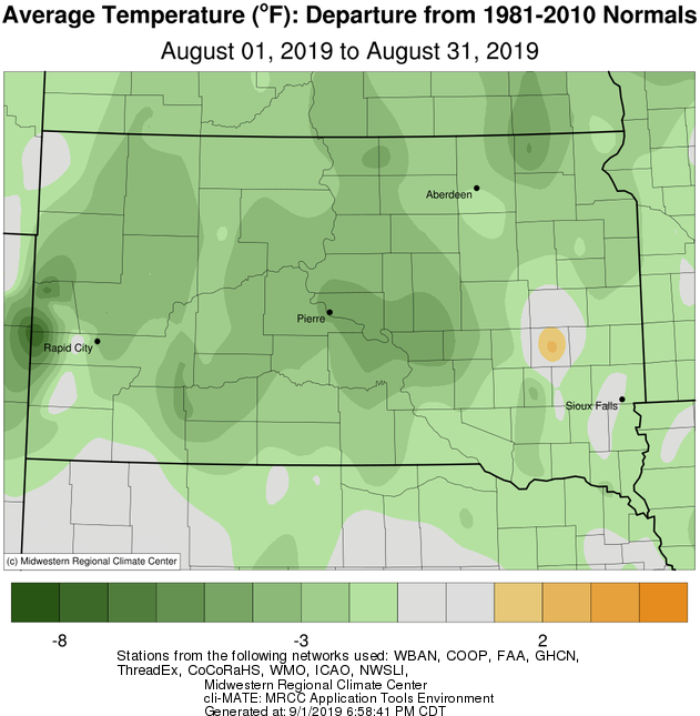
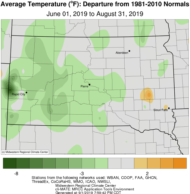
August 2019 featured below average temperatures on a whole, being anywhere between 1 and 5 degrees below average. Watertown failed to reach 84 degrees all August, which hasn’t happened since record keeping began in 1893. Sisseton failed to reach 86 degrees, which has only happened one other year (2014) since record keeping began in 1932.
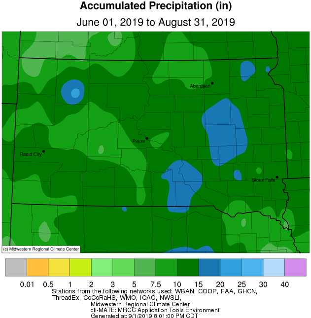
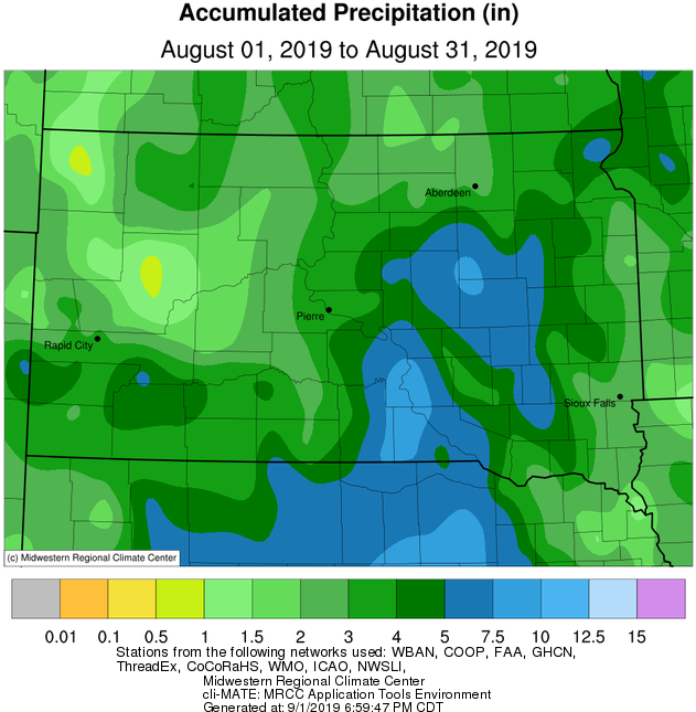
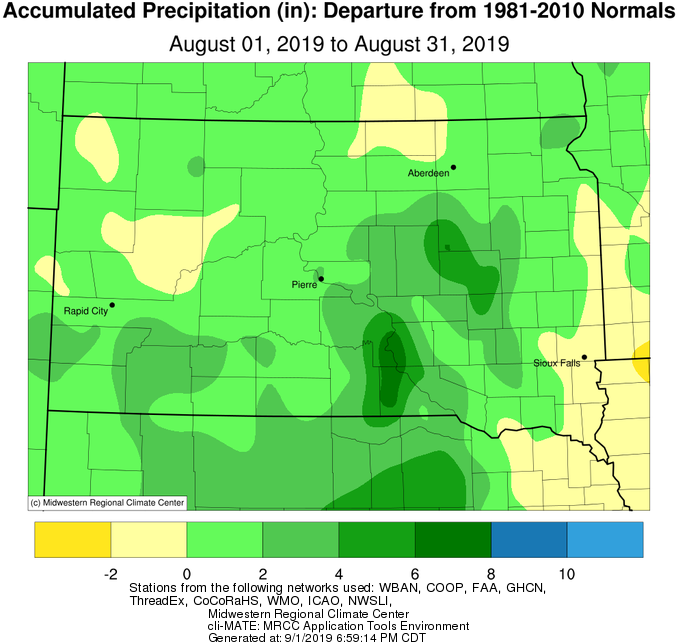
Precipitation was above average this month (once again) across the area, and some had more than 4” of excess rain. Significant rains and flooding resulted on the morning of August 2nd, when localized rainfall of up to 8” fell. For more on this event, visit https://www.weather.gov/abr/August2nd2019HeavyRainandFlooding. Additionally, a daily rainfall record of 1.66” was set in Pierre on the 11th (1.22” in 2002). Looking at the bigger picture, Sisseton recorded their 9th wettest August on record, and Kennebec observed their 5th wettest August. Year-to-date through August 31st, Sisseton has had 23.57” of precipitation which ranks 7th, Watertown has had 25.27” which ranks 4th, Mobridge 20.52” which ranks 3rd, Pierre 24.15” which ranks 2nd, and Kennebec 28.81” which ranks 1st… and by the wide margin of 3.69”. In fact, Kennebec already ranks 2nd for precipitation for an entire year, with 4 months remaining (30.25” in 1915). Record keeping at Kennebec began in 1893.
The area saw an uptick in severe weather in August. Aug 6th yielded baseball plus sized hail and damaging wind gusts across portions of Central South Dakota. Two separate large hail scars were visible from satellite a few days after, depicting the devastated crops. These storms later went on to produce an EF-1 tornado further south in Burke. For more on this event, visit https://www.weather.gov/abr/20190806_LargeHail. Storms fired once again on the 9th and 15th, and an EF-0 tornado was produced each day. As of August 31st, there have been a total of 3 confirmed tornadoes in our County Warning Area (which covers roughly a third of South Dakota). South Dakota averages 36 tornadoes each year.
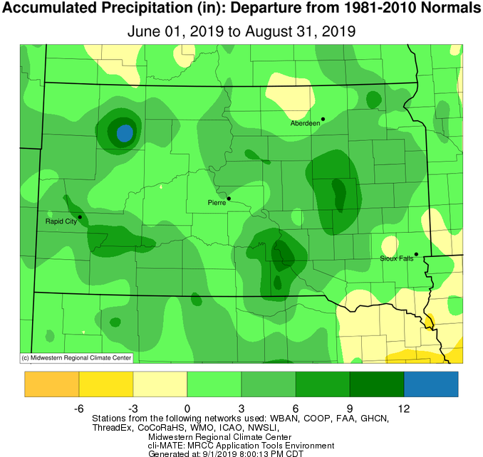
Meteorological summer extends from June 1st through August 31st. This summer on a whole was slightly below normal in temperatures, and very wet. Those along and near a line from Sisseton to Chamberlain received generally anywhere from 3 to 9 inches of above average rainfall.
|
August 2019 |
||||
|
Temperature Data |
Aberdeen |
Sisseton |
Wheaton |
Watertown |
|
Warmest Temperature / Date |
88°/ 6th |
85°/ 6th |
85°/ 6, 19th |
83°/ 4,6,17th |
|
Coldest Temperature / Date |
43°/ 30th |
44°/ 30th |
50°/ 30th |
46°/ 30th |
|
Average High / Departure from Normal |
78.6°/ -3.2° |
75.7°/ -5.1° |
76.3°/ -4.4° |
75.4°/ -4.5° |
|
Average Low / Departure from Normal |
57.5°/ +1.3° |
56.2°/ -1.2° |
58.2°/ +0.0° |
57.6°/ +0.4° |
|
Monthly Average / Departure from Normal |
68.1°/ -0.9° |
65.9°/ -3.2° |
67.3°/ -2.1° |
66.5°/ -2.1° |
|
Precipitation Data |
||||
|
Monthly Precipitation / Departure from Normal |
2.33”/ -0.10” |
4.94”/+2.5” |
4.44”/ +1.62” |
3.77”/ +0.99” |
|
Most Precipitation in 24 hours / Date |
0.80”/ 17th |
1.49”/10,15th |
1.45”/ 10th |
1.18”/2nd |
|
Monthly Snowfall / Departure from Normal |
N/A |
N/A |
N/A |
N/A |
|
Most Snow in 24 hours / Date |
N/A |
N/A |
N/A |
N/A |
|
Temperature Data |
Pierre |
Kennebec |
Mobridge |
Timber Lake |
|
Warmest Temperature / Date |
94°/ 6th |
91°/ 6th |
93°/ 6th |
91°/ 6th |
|
Coldest Temperature / Date |
47°/ 30th |
45°/ 28th |
47°/ 30th |
42°/ 28th |
|
Average High / Departure from Normal |
79.5°/ -7.8° |
81.0°/ -7.4° |
79.8°/ -5.0° |
79.3°/ -6.1° |
|
Average Low / Departure from Normal |
59.2°/ -0.9° |
58.9°/ -1.1° |
59.0°/ +1.1° |
57.5°/ -0.4° |
|
Monthly Average / Departure from Normal |
69.3°/ -4.4° |
70.2°/ -4.0° |
69.4°/ -2.0° |
68.6°/ -3.0° |
|
Precipitation Data |
||||
|
Monthly Precipitation / Departure from Normal |
3.73”/ +1.93” |
5.07”/ +3.14” |
3.21”/ +1.18” |
2.16”/ +0.45” |
|
Most Precipitation in 24 hours / Date |
1.66”/ 11th |
1.61”/ 9th |
1.02”/ 9th |
0.90”/ 12th |
|
Monthly Snowfall / Departure from Normal |
N/A |
N/A |
N/A |
N/A |
|
Most Snow in 24 hours / Date |
N/A |
N/A |
N/A |
N/A |
Average temperature departure from normal this August, courtesy of the Midwestern Regional Climate Center
Total precipitation (left) and precipitation departures (right) this August, courtesy of the Midwestern Regional Climate Center
Average temperature departure from normal this summer (June, July and August), courtesy of the Midwestern Regional Climate Center
Total precipitation (left) and precipitation departures (right) this summer (June, July and August), courtesy of the Midwestern Regional Climate Center