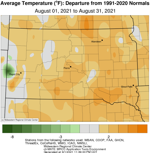
August 2021 finished above average temperature-wise across the region, anywhere from near normal to 4 degrees locally. While not quite as hot as the other months this summer, thanks in large part to a wetter pattern, Aberdeen recorded 11 days at or above 90 degrees which was the second most since 1983. Additionally, Pierre recorded 4 days at or above 100 degrees, tied most since 2003.
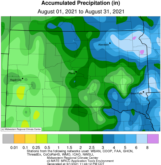
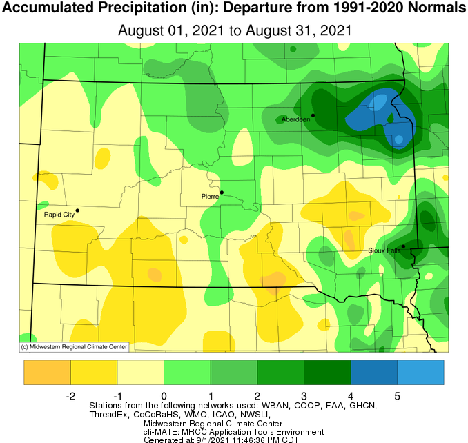
Above average precipitation was recorded for most areas, particularly from the James River Valley eastward into west central Minnesota. Several rounds of thunderstorms and heavy rain impacted this area from the 6-8th and again during the final approximately third of the month, leading to impressive and even record-breaking totals in some cases. Sisseton for instance recorded two daily record rainfalls, on the 8th (3.26”) and 28th (1.66”), and finished with a whopping 7.98” of rain for the month. This ranks as the wettest August on record since consistent reliable record keeping began in 1931, and the 8th wettest month overall (1st place being May 1965 with 9.76”). Sisseton is now at a surplus for the year. Aberdeen recorded 3.74” of rain over a 9 day period from Aug 20-28th, which was more than the previous 102 days combined from May 9th to Aug 19th. Similarly, Mobridge picked up 4.19” over a 12 day period from Aug 19-30th, which was more than the previous 101 days combined from May 9th to Aug 18th.
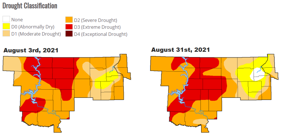
Unfortunately, severe weather was the price to pay for this reprieve. The most significant and/or widespread events occurred on August 22nd (~80 mph wind gusts and/or large hail in and around Aberdeen), August 23-24th (measured 112 mph wind gust 11 miles south of Bullhead), August 26th (morning severe wind from Faulk to Deuel Counties), and August 28th (morning significant hail from Corson to Big Stone Counties). Much more on this last event can be found here. Despite the rain and thunderstorms, drought conditions continued through the month, in particular for areas along and west of the James River Valley where widespread Severe to Extreme Drought remained as of the 31st.
|
August 2021 |
||||
|
Temperature Data |
Aberdeen |
Sisseton |
Wheaton |
Watertown |
|
Warmest Temperature / Date |
97 / 17, 18th |
92 / 17th |
91 / 17,18,19 |
90 / 17th |
|
Coldest Temperature / Date |
44 / 13th |
47 / 13th |
52 / 13th |
49 / 1st |
|
Average High / Departure from Normal |
87.0 / +4.1 |
82.9 / +2.0 |
80.8 / +0.2 |
82.1 / +2.6 |
|
Average Low / Departure from Normal |
58.9 / +2.4 |
60.0 / +3.1 |
60.1 / +0.5 |
59.1 / +1.6 |
|
Monthly Average / Departure from Normal |
73.0 / +3.3 |
71.4 / +2.5 |
70.5 / +0.4 |
70.6 / +2.1 |
|
Precipitation Data |
|
|
|
|
|
Monthly Precipitation / Departure from Normal |
4.10 / +1.86 |
7.98 / +5.37 |
5.96 / +3.24 |
4.77 / +1.88 |
|
Most Precipitation in 24 hours / Date |
1.04 / 28th |
3.26 / 8th |
1.77 / 8th |
1.33 / 26th |
|
Monthly Snowfall / Departure from Normal |
0.0 / +0.0 |
0.0 / +0.0 |
0.0 / +0.0 |
0.0 / +0.0 |
|
Most Snow in 24 hours / Date |
N/A |
N/A |
N/A |
N/A |
|
Temperature Data |
Pierre |
Kennebec |
Mobridge |
Timber Lake (Missing 30th & 31st) |
|
Warmest Temperature / Date |
106 / 17th |
101 / 17th |
103 / 17th |
99 / 8, 15th |
|
Coldest Temperature / Date |
53 / 23rd |
50 / 29th |
49 / 13th |
48 / 13, 21st |
|
Average High / Departure from Normal |
90.2 / +3.6 |
91.2 / +3.4 |
88.5 / +2.5 |
87.7 / +2.6 |
|
Average Low / Departure from Normal |
61.0 / +1.6 |
60.6 / +1.4 |
60.7 / +1.1 |
58.6 / +1.1 |
|
Monthly Average / Departure from Normal |
75.6 / +2.6 |
76.2 / +2.7 |
74.6 / +1.8 |
73.4 / +2.1 |
|
Precipitation Data |
|
|
|
|
|
Monthly Precipitation / Departure from Normal |
2.65 / +0.70 |
2.95 / +0.64 |
4.29 / +2.24 |
2.5 / +0.72 |
|
Most Precipitation in 24 hours / Date |
1.62 / 27th |
1.03 / 7th |
1.03 / 28th |
1.21 / 20th |
|
Monthly Snowfall / Departure from Normal |
0.0 / +0.0 |
0.0 / +0.0 |
0.0 / +0.0 |
0.0 / +0.0 |
|
Most Snow in 24 hours / Date |
N/A |
N/A |
N/A |
N/A |
Average temperature departures from normal for August 2021, courtesy of the Midwestern Regional Climate Center
Total precipitation for August 2021, courtesy of the Midwestern Regional Climate Center
Precipitation departures from normal for August 2021, courtesy of the Midwestern Regional Climate Center
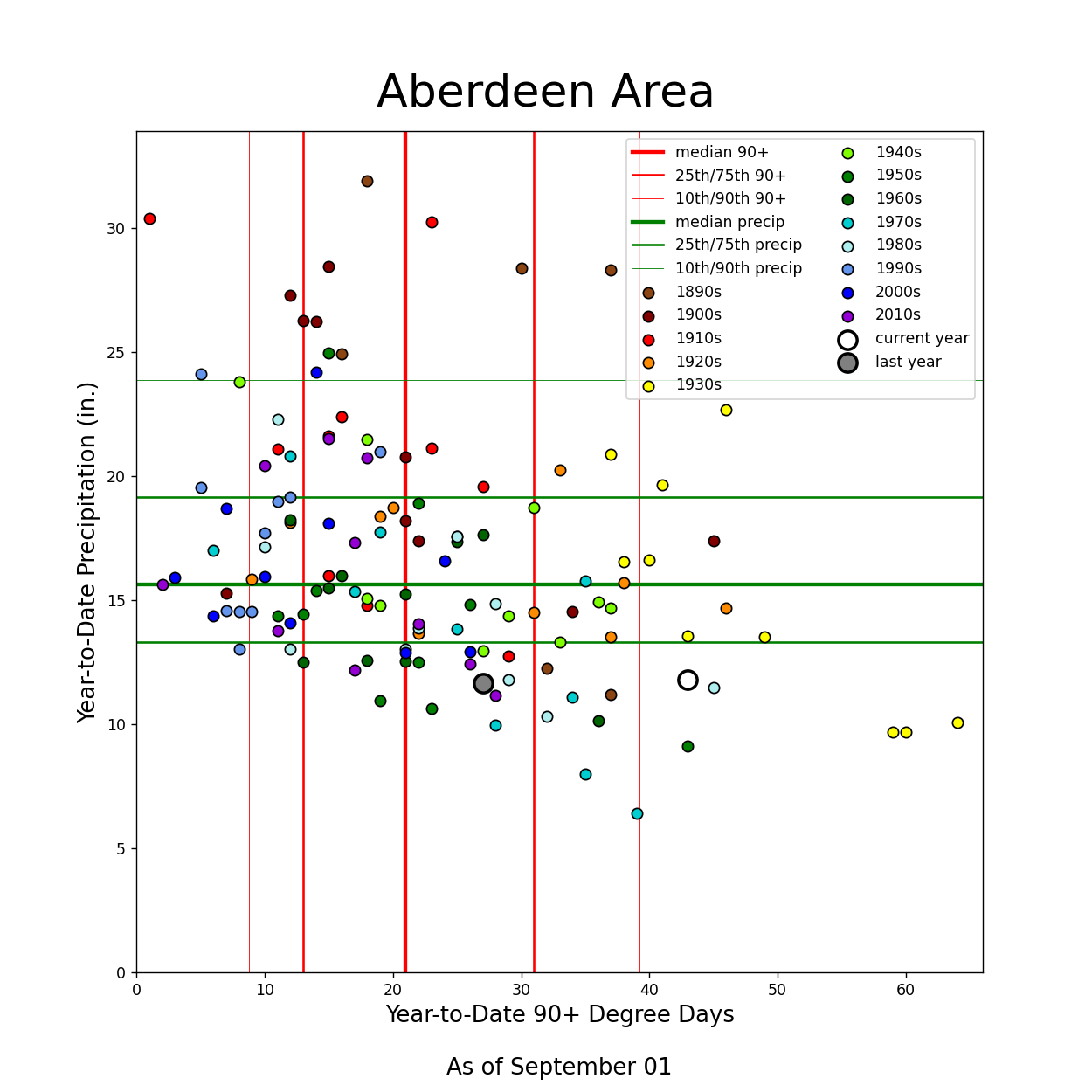
Year-to-date information (as of Aug 1) regarding number of 90+ degree days (horizontal axis) and precipitation totals (vertical axis) at Aberdeen and Pierre. The large white dot represents this year, whereas the smaller dots other years in the historical database. This information for additional locations can be found here
Drought conditions around the beginning (left) and end (right) of the month, from the US Drought Monitor
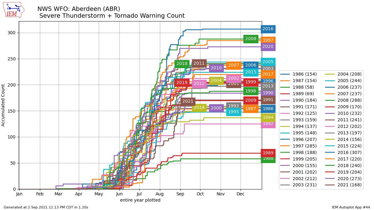
Plot of combined Severe Thunderstorm and Tornado Warnings issued by NWS Aberdeen, SD since 1986 (35 year record), courtesy of ISU's Iowa Environmental Mesonet. 70 warnings were issued in 12 days from Aug 19-31st 2021, vs 98 total warnings for the entire season prior (96 days starting at the first day a warning was issued). 2021 now ranks as having the 11th fewest warnings for a year.
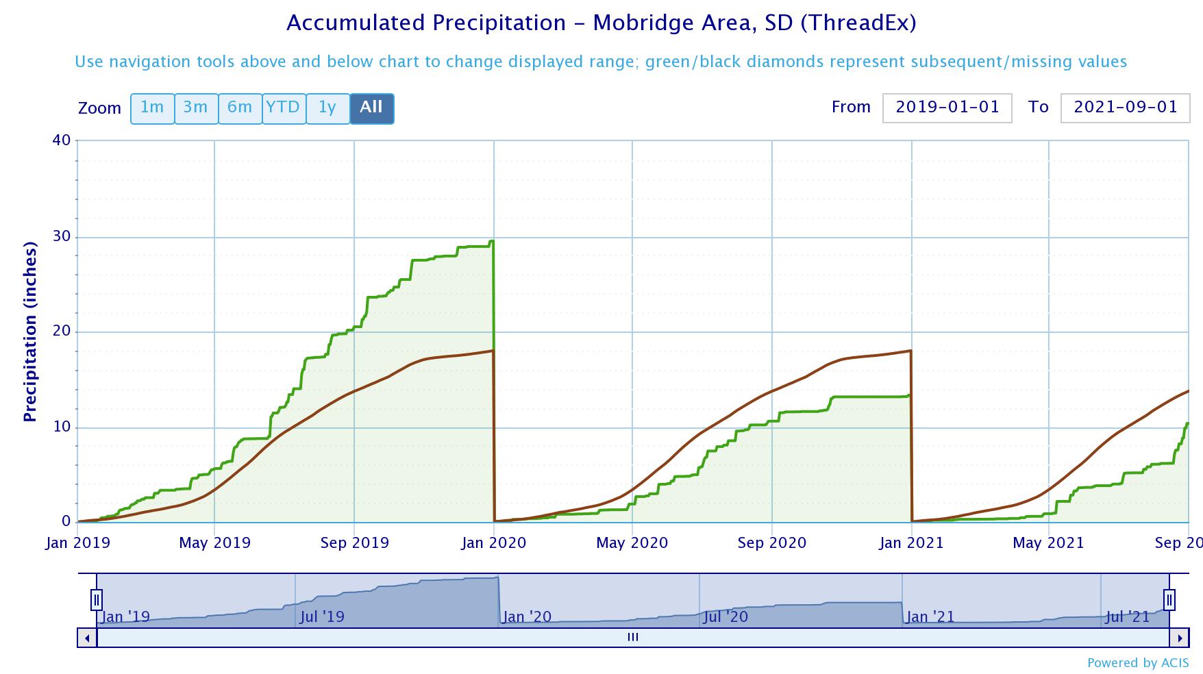
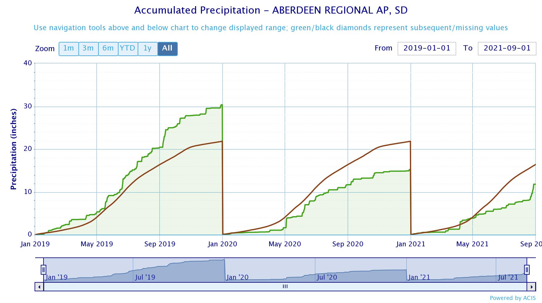
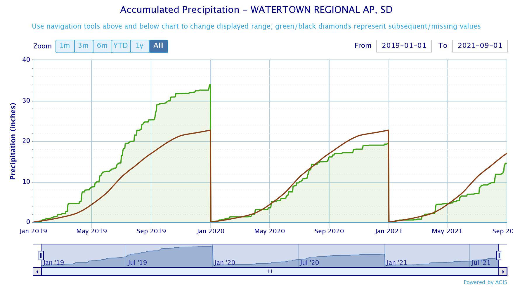
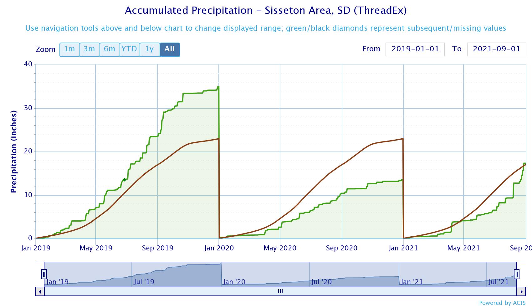
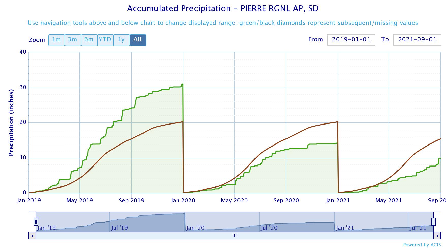
A broader look at observed precipitation amounts (green line/fill) and how they compare to normal (brown line) for several locations, beginning on January 1st of 2019 and restarting on January 1st of each successive year. After a record-setting wet August at Sisseton, they are now above average for the year (2021) by 0.31" as of August 31st. Other locations remain below average for the year however: -2.4" at Watertown, -3.37" at Mobridge, -4.56" at Aberdeen and -5.57" at Pierre.
Aberdeen
Watertown
Sisseton
Pierre
Mobridge