Widespread life-threatening flash and urban flooding continues in south-central Texas, with considerable flooding impacts possible across central Texas. Wildfire smoke is impacting air quality across much of the Great Lakes region into southern New England and the Mid-Atlantic. Monsoonal thunderstorms may produce isolated to scattered flash flooding across the Southwest into the Great Basin. Read More >
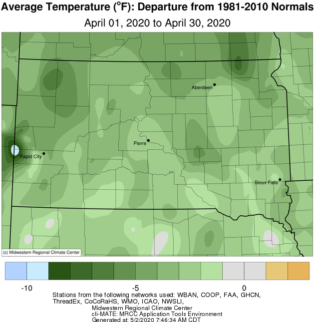
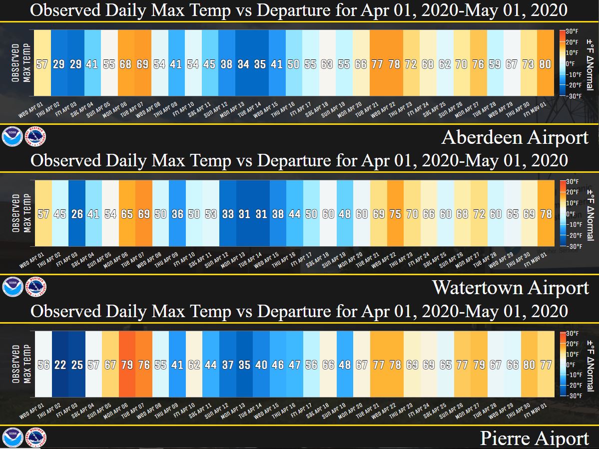
April 2020 finished anywhere from 2 to 5 degrees below normal on a whole across the area, even though the final third of the month featured days with near or above average temperatures. Sisseton set record daily cold high temperatures on the 12th (30 degrees vs 33 in 2013) and 14th (28 degrees vs 32 in 2013), as well as a record daily low temperature on the 13th (17 degrees vs 19 in 1939).
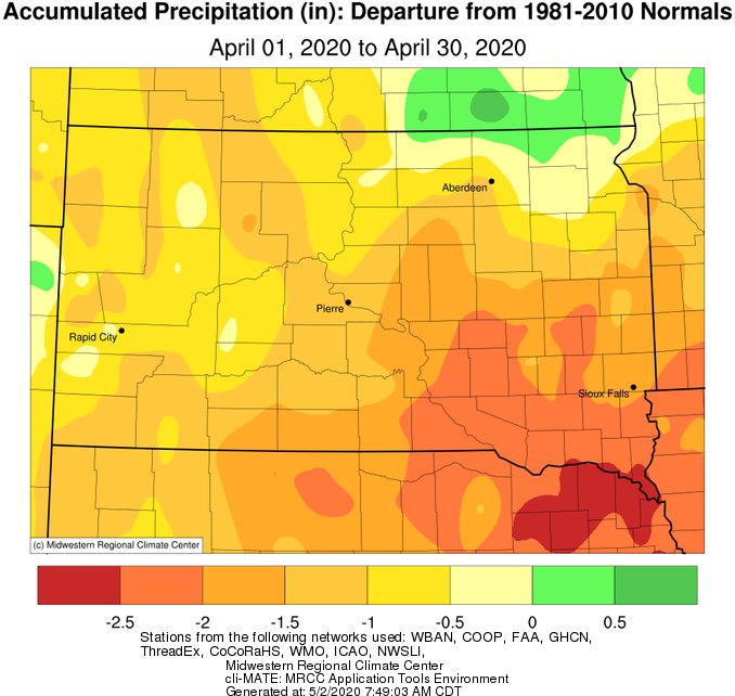
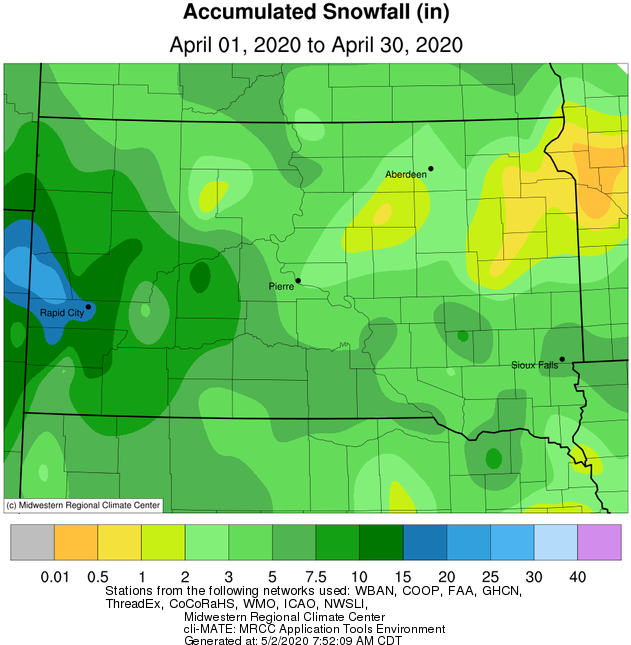
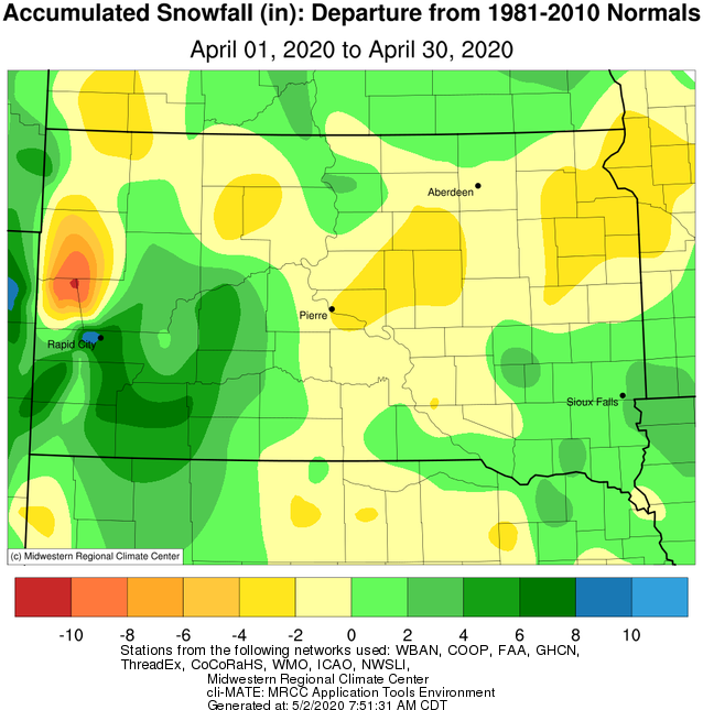
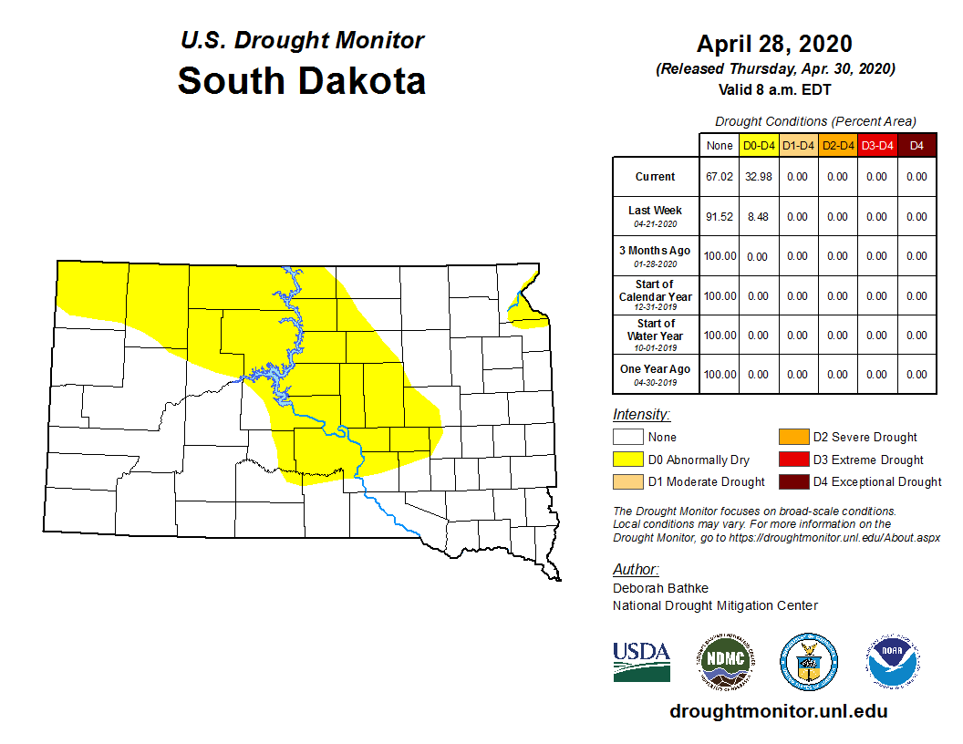
While several rounds of precipitation occurred, all areas finished the month below average except for those near the North Dakota border roughly from Eureka to Wheaton. Portions of central and east central South Dakota were driest, finishing 1 to 2 inches below average. Snowfall was generally below climatological normals for April as well. Below normal precipitation has been the trend this year, so much so that the US Drought Monitor has placed much of Central South Dakota under the “Abnormally Dry” category (one stage away from drought). Meanwhile, the James River near Columbia, Stratford and Ashton remained at either Moderate or Major Flood Stage through the entirety of April.
The most significant precipitation events included: 1.) A mix of snow (portions of northeastern and central SD picked up 2-6+”), ice pellets, freezing rain (eastern SD and west central MN) and even some lightning and thunder on Apr 1-2nd, 2.) A couple severe thunderstorms with quarter to golf ball sized hail across portions of McPherson and Edmunds to Traverse Counties on the evening of the 6th, 3.) A snow squall which impacted portions of northeastern SD on the morning of the 9th, and 4.) 1-5+” of snow across south central SD on 11-12th.
|
April 2020 |
||||
|
Temperature Data |
Aberdeen |
Sisseton |
Wheaton |
Watertown |
|
Warmest Temperature / Date |
78 / 22nd |
72 / 27th |
72 / 27th |
75 / 22nd |
|
Coldest Temperature / Date |
7 / 4th |
11 / 4th |
14 / 4th |
11 / 4th |
|
Average High / Departure from Normal |
56.0 / -1.0 |
51.7 / -4.6 |
52.6 / -2.6 |
53.8 / -1.8 |
|
Average Low / Departure from Normal |
27.8 / -4.0 |
28.9 / -3.7 |
31.3 / -0.7 |
28.5 / -3.6 |
|
Monthly Average / Departure from Normal |
41.9 / -2.5 |
40.3 / -4.2 |
42.0 / -1.6 |
41.2 / -2.6 |
|
Precipitation Data |
|
|
|
|
|
Monthly Precipitation / Departure from Normal |
0.91 / -0.94 |
1.72 / -0.56 |
2.12 / -0.12 |
1.58 / -0.44 |
|
Most Precipitation in 24 hours / Date |
0.42 / 28th |
0.57 / 1st |
0.94 / 2nd |
0.89 / 1st |
|
Monthly Snowfall / Departure from Normal |
2.2 / -0.9 |
3.0 / -0.8 |
0.5 / -3.9 |
0.6 / -2.7 |
|
Most Snow in 24 hours / Date |
1.9 / 2nd |
2.7 / 2nd |
0.5 / 3rd |
0.5 / 2nd |
|
Temperature Data |
Pierre |
Kennebec |
Mobridge |
Timber Lake |
|
Warmest Temperature / Date |
80 / 30th |
80 / 30th |
80 / 21st |
78 / 30th |
|
Coldest Temperature / Date |
9 / 3rd, 4th |
10 / 3rd |
7 / 4th |
7 / 4th |
|
Average High / Departure from Normal |
58.4 / -1.3 |
62.1 / -0.1 |
57.7 / -0.3 |
56.5 / -2.3 |
|
Average Low / Departure from Normal |
28.6 / -5.6 |
28.8 / -5.2 |
27.1 / -5.4 |
27.6 / -5.1 |
|
Monthly Average / Departure from Normal |
43.5 / -3.5 |
45.5 / -2.6 |
42.4 / -2.9 |
42.1 / -3.4 |
|
Precipitation Data |
|
|
|
|
|
Monthly Precipitation / Departure from Normal |
0.78 / -1.03 |
0.55 / -1.61 |
0.99 / -0.58 |
0.88 / -0.82 |
|
Most Precipitation in 24 hours / Date |
0.43 / 2nd |
0.30 / 12th |
0.32 / 28th |
0.41 / 28th |
|
Monthly Snowfall / Departure from Normal |
2.7 / -1.4 |
2.8 / -1.1 |
6.2 / +3.0 |
5.0 / -0.3 |
|
Most Snow in 24 hours / Date |
2.2 / 2nd |
2.5 / 12th |
5.3 / 2nd |
2.8 / 2nd |
April 2020 temperature departure, courtesy of the Midwestern Regional Climate Center
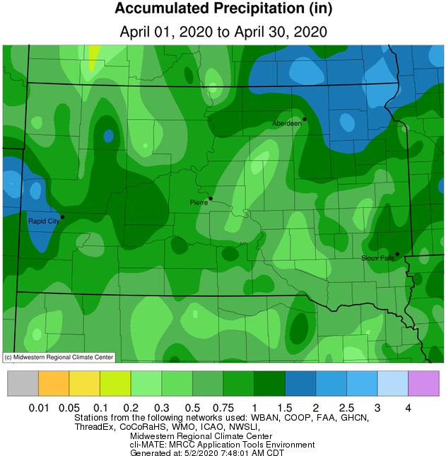
April 2020 precipitation totals (left) and departures (right), courtesy of the Midwestern Regional Climate Center
April 2020 snowfall totals (left) and departures (right), courtesy of the Midwestern Regional Climate Center
Day-by-day observed high temperatures (value) and corresponding departures from normal (shading) for Aberdeen, Watertown and Pierre
US Drought Monitor as of April 28th, from https://droughtmonitor.unl.edu/CurrentMap/StateDroughtMonitor.aspx?SD
More details about the April 9th morning snow squall below