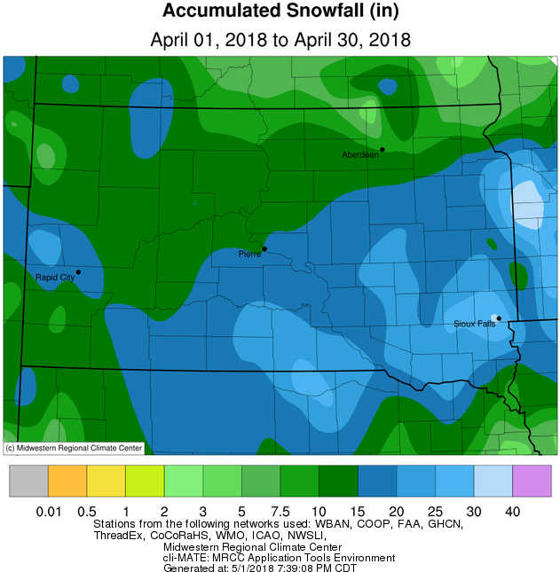
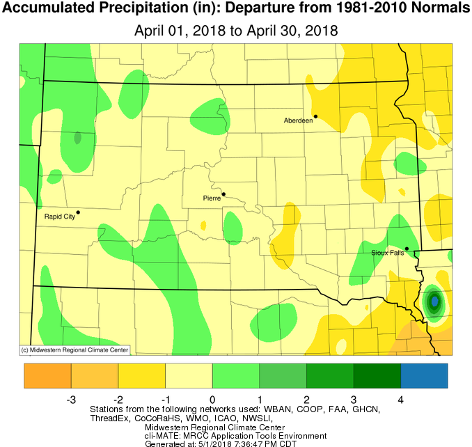
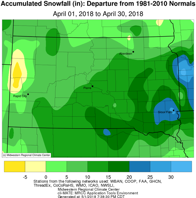
Cold and snow continued impacting the area in April. The month began with light snow across the region on the 2nd and 3rd with amounts ranging between 2 – 6 inches. The storm system was followed by an Arctic high pressure which brought bitter cold temperatures on April 4th, and then another snow system struck on the 8th. Winter weather was far from over by this point however, as a dynamic and historic springtime storm system severely impacted the Northern Plains on April 13th and 14th. Widespread snowfall totals of one to two feet across the southern half of South Dakota and southern Minnesota combined with winds gusts of up to 50 mph to produce widespread blizzard conditions for many hours. Both portions of I-29 and I-90 were closed from the afternoon of the 13th through the morning of the 15th. More information here: https://www.weather.gov/abr/April13-14BlizzardSummary. By the time April 2018 was over, it ranked as the 2nd snowiest on record in Watertown (29.5” in 2008), 3rd snowiest in Kennebec, 5th in Pierre, 7th in Timber Lake, and 10th in Mobridge. Most locations finished 5-15 inches of snow above average. Several daily snowfall total records (not necessarily storm total) were recorded throughout the month. Thanks to an incredibly active end of the 2017-2018 snow season, Kennebec ranks as the 7th snowiest season on record with 56.9” of snow, and Watertown ranks 10th with 53.1”. Despite the much above average snowfall, some areas were below average on total precipitation, particularly across northeastern South Dakota and western Minnesota where 1-2" of moisture was lacking.
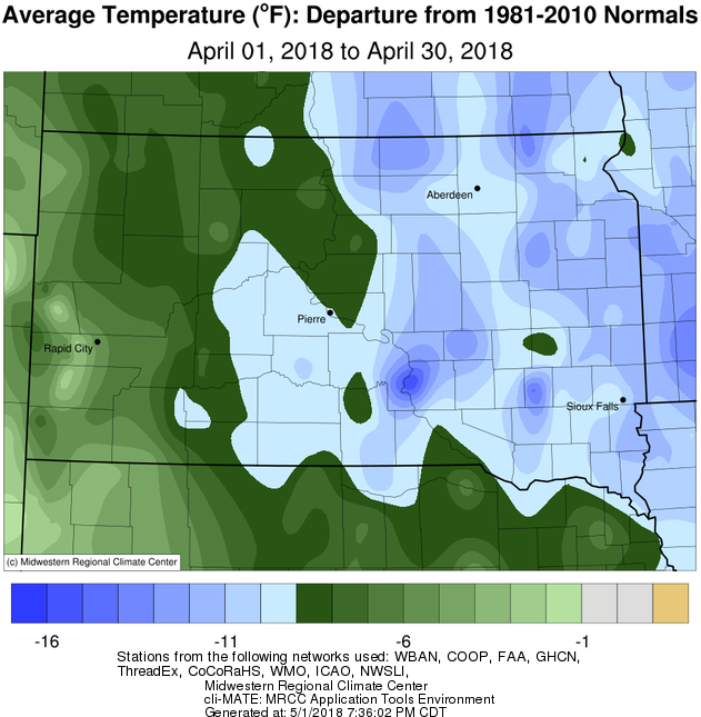
Temperatures on a whole during April 2018 were very much below average, by as much as 8 to 12 degrees. The coldest air arrived on the 3rd with highs only in the 20s for most locations. Low temperatures the morning of the 4th were in the single digits on either side of zero. Several locations saw record lows the morning of the 4th, including all-time April low temperatures in Aberdeen of -6 degrees and in Pierre of 0 degrees. Several record cold daily low and high temperatures were set through April 16th before conditions began to moderate towards the end of the month. Despite this warm-up, April 2018 will go down in the record books as one of the very coldest on record across the area: Kennebec set their record (2nd place was 39.9 degrees in 2013), Aberdeen, Watertown, and Pierre came in at 2nd place for coldest April on record (record coldest Aprils were 34.9 degrees in 2013, 33.5 degrees in 1950, and 37.6 degrees in 2013 respectively), and Sisseton, Mobridge, Timber Lake and Wheaton ranked 3rd. Watertown observed only 4 days with high temperatures above average, and Sisseton only 5. Kennebec was only 3.4 degrees above the monthly normal temperature of March, and Pierre only 3.6 degrees!
|
APRIL 2018 |
||||
|
Temperature Data |
Aberdeen |
Sisseton |
Wheaton |
Watertown |
|
Warmest Temperature / Date |
82 / 30th |
80 / 30th |
75 / 23th |
80 / 30th |
|
Coldest Temperature / Date |
-6 / 4th |
7 / 6th |
7 / 3rd, 5th |
-3 / 4th |
|
Average High / Departure from Normal |
48.6 / -8.4 |
46.3 / -10.0 |
45.2 / -10.0 |
44 / -11.6 |
|
Average Low / Departure from Normal |
22.8 / -9.0 |
25.9 / -6.7 |
25.4 / -6.6 |
23.6 / -8.5 |
|
Monthly Average / Departure from Normal |
35.7 / -8.7 |
36.1 / -8.4 |
35.3 / -8.3 |
33.8 / -10.0 |
|
Precipitation Data |
|
|
|
|
|
Monthly Precipitation / Departure from Normal |
0.98 / -0.87 |
0.64 / -1.64 |
0.52 / -1.72 |
0.97 / -1.05 |
|
Monthly Snowfall / Departure from Normal |
10.3 / +7.2 |
7.5 / +3.7 |
6.2 / +1.8 |
17.5 / +14.2 |
|
Most Precipitation in 24 hours / Date |
0.36 / 8th |
0.29 / 2nd |
0.20 / 2nd |
0.23 / 13th |
|
Most Snow in 24 hours / Date |
6.8 / 8th |
3.0 / 2, 8th |
2.3 / 2nd |
7.0 / 8th |
|
Temperature Data |
Pierre |
Kennebec |
Mobridge |
Timber Lake |
|
Warmest Temperature / Date |
80 / 29th |
83 / 29,30th |
83 / 29th |
78 / 29th |
|
Coldest Temperature / Date |
0 / 4th |
3 / 4th |
1 / 4th |
2 / 6th |
|
Average High / Departure from Normal |
50.8 / -8.9 |
52.7 / -9.5 |
49.9 / -8.1 |
50.3 / -8.5 |
|
Average Low / Departure from Normal |
25.2 / -9.0 |
25.6 / -8.4 |
25.4 / -7.1 |
25.0 / -7.7 |
|
Monthly Average / Departure from Normal |
38.0 / -9.0 |
39.1 / -9.0 |
37.7 / -7.6 |
37.6 / -8.2 |
|
Precipitation Data |
|
|
|
|
|
Monthly Precipitation / Departure from Normal |
1.67 / -0.14 |
1.70 / -0.46 |
2.02 / +0.45 |
1.70 / 0.00 |
|
Monthly Snowfall / Departure from Normal |
16.0 / +11.9 |
21.3 / +17.4 |
9.8 / +6.6 |
11.9 / +6.6 |
|
Most Precipitation in 24 hours / Date |
0.75 / 13th |
0.59 / 13th |
0.93 / 24th |
0.76 / 8th |
|
Most Snow in 24 hours / Date |
8.0 / 13th |
9.0 / 13th |
5.8 / 8th |
8.2 / 8th |
Temperature departures during April 2018, from the Midwestern Regional Climate Center
Precipitation departures during April 2018, from the Midwestern Regional Climate Center
Snowfall departures during April 2018, from the Midwestern Regional Climate Center
Total snowfall during April 2018, from the Midwestern Regional Climate Center