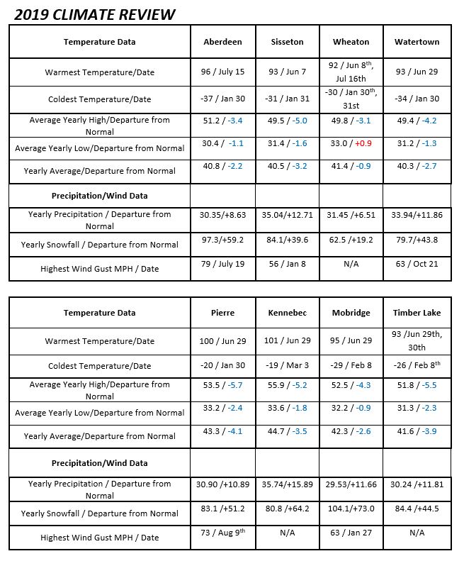
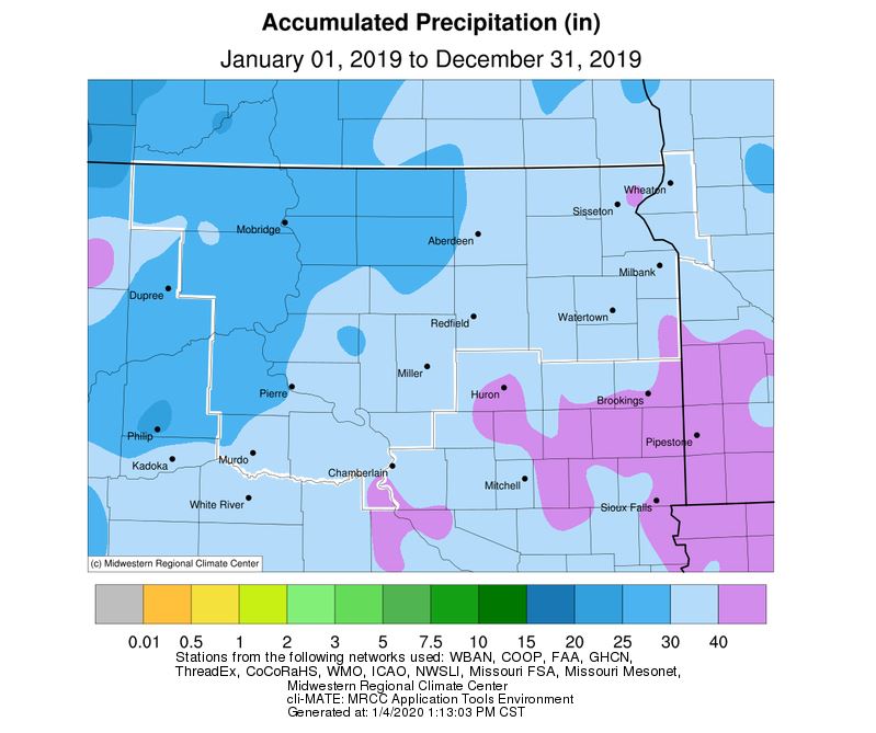
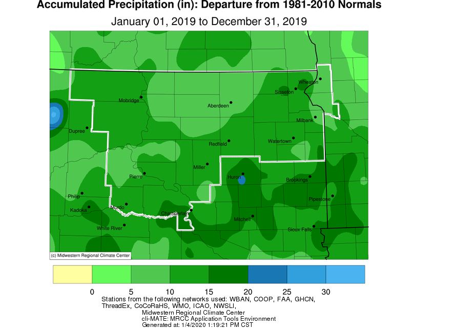
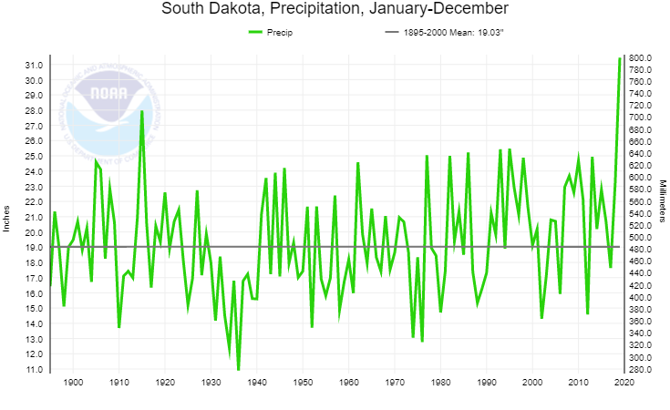
2019 was a very wet and cold year across central and northeast South Dakota and west central Minnesota. There were very little dry periods to be had throughout 2019. The wet year affected everyone with extensive flooding on rivers, roads, and agricultural land bringing widespread damage in the millions of dollars to crops and property. The total precipitation for 2019 was generally from 30 to 36 inches with some higher amounts likely at locations not shown here. These amounts were extraordinary ranging from 6 and a half to almost 16 inches above normal. With these extreme amounts came some all-time yearly precipitation records for several locations including Mobridge, Sisseton, and Kennebec where they finished first. Pierre, Timber Lake, and Watertown were second all-time. Aberdeen and Wheaton finished out the year ranked ninth all-time. State-wide, South Dakota recorded their wettest year since 1895 with an average of 31.44” of precipitation. This is 12.41” above average, and breaks the previous record of 27.97” set in 1915.
As for snowfall, the snow season runs from July through June which crosses years and therefore winters are referred to 1996-97, 2018-19, etc. Since the snow in 2019 was high at the beginning and ending of the year with many winter storms, 2019 snowfall amounts across the region were extreme as is shown in the chart. Snowfall amounts for 2019 ranged from just over 60 to nearly 105 inches with some locations not shown here likely higher. With the first part of this winter already snowy, several locations were already near to above normal with several locations recording from 30 to 50 inches.
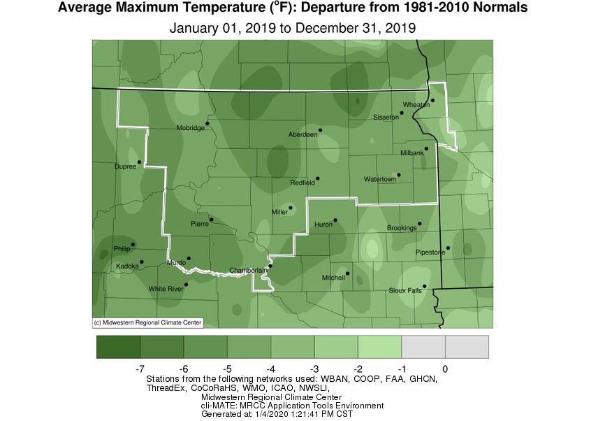
Due to the numerous weather system through the year, the precipitation and cloud cover along with mainly Arctic outbreaks early in 2019, average yearly temperatures were cold ranging from 1 to 4 degrees below normal. Average highs ranged from 3 to 6 degrees below normal for 2019. The lows for the year were early on with minus 20s and minus 30s. In late January, some locations did reach the lower 40s below zero in northeast South Dakota. Highs for the year were mostly in the 90s with a few 100s in central South Dakota.

Precipitation data below is from https://www.ncdc.noaa.gov/cag/statewide/time-series and shows state-wide averaged precipitation amounts since 1895 (125 years’ worth of data). 2019, on the far right of the graph, ranks first.
Below is a compilation of each month's summary from through the year.
January
The first half of January 2019 was largely mild and dry, however a change in pattern took hold through the second half. On a whole, much of the area finished below average by 1-5 degrees with near average temperatures across portions of central and north central South Dakota. Arctic, even historic cold gripped the area January 30th and 31st. Record daily cold low and high temperatures were set across much of northeastern South Dakota and west central Minnesota on the 30th and 31st. Some of the coldest readings were -40 F in Britton, -38 F in Summit, -37 in Aberdeen, -37 in Eureka and -33 F in Watertown. Many areas spent around 60 hours (over 2 days) below zero. Winds were a factor as well, leading to exceptionally cold wind chills including -59 F at Sisseton, -58 F in Graceville, -57 F in Ortonville, -56 in Wheaton and -54 in Watertown. This event was part of a much larger historic outbreak of air that extended from the Dakotas through MN, WI, IL, MI, etc.
In terms of precipitation/snowfall, much of the area finished above average. Some areas of northeastern South Dakota finished 4-10 inches of snow above average. Again, much of this fell during a more active pattern during the second half of the month. Two systems of note impacted the area. The first, on the 18th, produced a general 2-6” of snow fell mainly across central and eastern South Dakota. The second, on the 27-28th, produced a general swath of 2-6” of snow across northeastern South Dakota and west central Minnesota. This system also produced significant winds with gusts of 60-70 mph and blizzard conditions mainly across/near the James River Valley. The onset of this blizzard was very rapid, which contributed to many accidents on the roadways.
February
Aside from the relatively localized banded snow event on the 6th in which Mobridge broke a daily snowfall record of 7.6” (https://www.weather.gov/abr/February6thand7thBandedsnowandBlizzardSummary), there were no significant heavy snow storms. Instead, frequent fluffy 2-5” snow events added up substantially. This February will go down as the 6th snowiest on record in Aberdeen, 3rd snowiest (tie) in Pierre, 7th in Watertown, 1st in Mobridge (the preliminary total of 39” this February breaks the record for most snow during *any* month on record, previously held by March of 1966 with 36.3”), 6th in Wheaton, and 3rd in Timber Lake. All of this snow filled most ditches, and its generally fluffy nature made it very susceptible to blowing/drifting. As a result, roads conditions often deteriorated whenever the wind blew. Blizzard warnings were issued for the 7th and 25th across portions of northeastern South Dakota and west central Minnesota, as strong winds greatly reduced visibilities. Temperatures failed to reach the melting point for many this month, and new snow continued to exceed what was able to settle. Thus, snow depths continued to rise across the area. As of the 28th, Andover and Westport’s snow depth was reported at 30”, Clark was at 37”, and Britton 40”.
Substantial snow depths and consistent new snow cover allowed for the development of record-territory cold temperatures. Aberdeen recorded their 3rd coldest February on record, it was Pierre’s 2nd coldest, 4th in Watertown, 2nd in Mobridge, 2nd in Sisseton, 1st in Wheaton, 4th (tie) in Kennebec, and 2nd in Timber Lake. Additionally, this was the first February on record where the temperature failed to rise above 22 degrees in Aberdeen and 25 degrees in Sisseton. For Aberdeen, this will be one of only 4 Februaries on record to never breach the melting point/32 degrees F. Looking back further, as of this writing on March 5th, the last time the temperature has reached the melting point in Aberdeen was 37 days ago on January 27th (35 degrees) granted it was only for about 15 minutes as a narrow warm surge of air brushed town out ahead of a potent blizzard. This was also the last time Aberdeen’s overall averaged daily temperature was above normal – the record streak of consecutive days below normal out of any time of the year was 50 days, which took place from Jan 11 – Feb 29th in 1936. If not for those 15 minutes on Jan 27th, 2019, Aberdeen’s current streak would be at 47 days. The last time the temp has been at the melting point in Pierre and Watertown was Feb 2nd. Regarding low temperatures, Aberdeen broke a record for number of nights with a low temperature below 0 degrees with 24 (23 in 1936 and 1917), Pierre, Watertown, Mobridge, Wheaton and Timber Lake ranked 2nd with anywhere from 19 to 23 nights below zero this February.
March
March 2019 featured two significant winter storm systems. The first, on March 9th, was a wet heavy snow producer of generally 6-12 inches across north central/northeastern South Dakota and west central Minnesota (https://www.weather.gov/abr/March9thWinterStormSummary). The second, on March 13-14th, was very severe and produced heavy rain, freezing rain, heavy snow, high winds, widespread blizzard conditions, and/or major drifting across the area. Long-lasting impacts ensued (https://www.weather.gov/abr/ReviewMarch13-14Blizzard). Daily snowfall and/or precipitation records were set on the 9th at Aberdeen, Sisseton and Mobridge, and on the 13th at Pierre, Sisseton and Watertown. The vast majority of the area observed above average snowfall and precipitation totals for the month, largely as a result of these storms (though two 2-4” type snowfall events also took place before the March 9th storm). Mobridge observed their 5th snowiest March on record with 18.1”, Timber Lake 9th with 16.1”, and Pierre 6th with 15.9”.
Much below average temperatures, on the order of generally 5 to 12 degrees, were observed this March 2019 on a whole. Exceptionally cold air overtook the area on the 2nd-3rd. On the 3rd, daily record low temperatures were set at Aberdeen, -20 F, and Pierre, -16 F, and daily record cold high temperatures were set at Aberdeen, -1 F, Mobridge, 2 F, Watertown, -5 F, and Sisseton, -2 F. Furthermore, Pierre set a record cold high temperature for the month of March of 0 F. Aberdeen reached 32 degrees for the first time in 43 consecutive days on the 11th (6th longest streak on record), Pierre 36 consecutive days ending on the 10th (2nd longest), Timber Lake 37 consecutive days ending on the 11th (tied 5th longest), Mobridge 38 consecutive days ending on the 11th (tied 5th), Wheaton 60 consecutive days ending on the 10th (3rd longest) and Sisseton 62 consecutive days ending on the 11th (2nd longest). Pierre recorded their 10th coldest March on record.
Significant snow depths reduced during the March 13-14th system (on the warm/rain side), and gradually after the system once temperatures warmed. Moderate, major and even historic flooding in some cases resulted across the Missouri, James, Big Sioux and other rivers/basins due to snowmelt and ice jams for much of the final third of the month, even without any additional meaningful precipitation. Flooding occurred in the absence of rivers as well, since snowmelt was unable to soak into the frozen ground. The scope and magnitude of this season’s snowmelt-variety flooding is rare, with only the springs of 2011 and 1997 being comparable in recent history. Significant impacts to a great number of roads and properties continue, and continue to expand, as April begins.
April
April 2019 featured generally slightly below average temperatures on a whole. Two main waves of above average temperatures were observed, one in early April and another in mid to late April. The 20th had high temperatures in the mid 80s to low 90s. Otherwise, conditions were on the chilly side with numerous daytime highs of 10-15 or more degrees below average. Sisseton set a daily record for a low temperature of 14 degrees on the 14th.
Generally above average precipitation was recorded this month, and much above average snowfall. Watertown had its 10th wettest April on record. Sisseton, Wheaton and Watertown had their 2nd snowiest April on record, 5th in Pierre, 6th in Kennebec, 9th in Mobridge and 10th in Aberdeen. This was due exclusively to a winter storm of historic proportions, which affected the area from the 10th through the 12th. Daily records for precipitation and snowfall, as well as much more information, can be found here: https://www.weather.gov/abr/April112019BlizzardSummary
As a result of more moisture on top of already saturated soils and swollen streams and lakes, flooding continued to plague the area. As of April 30th, a couple river gauges on the James River remain at Major Flood Stage.
May
May 2019 featured predominantly cool temperatures, anywhere from 4 to 7 degrees below normal, thanks to a jet stream pattern that kept the area on the cold side of several storm systems. Several locations ranked in the top 10 coldest Mays on record: Kennebec 10th, Sisseton 8th, Timber Lake tied 6th, and Pierre 3rd. Record cold daily low temps were recorded at Aberdeen and Sisseton on the 7th (24° and 26° respectively), and numerous record cold daily max temps were recorded from the 18th through the 22nd: Pierre on the 20th, 21st and 22nd (49°, 47°, 53°), Aberdeen on the 19th (46°), Mobridge on the 22nd (53°), Sisseton on the 19th (44°), Wheaton on the 20th (48°), Kennebec on the 19th, 20th, 21st and 22nd (47°, 52°, 46° 52°), and Timber Lake on the 18th and 22nd (45° and 48°).
Very wet weather accompanied the cooler temperatures, and a couple days of accumulating snow resulted (not unheard of in South Dakota). Portions of central South Dakota picked up a couple inches on May 6th and portions of Deuel County followed suit on May 8th, where an estimated 4” fell at Astoria. Above average total precipitation for May was observed at all locations, but the greatest departure was across central South Dakota where an impressive 4 to 8 inches of surplus rain fell. This May will go down as the second wettest on record in Pierre (7.24” in 1982) and the wettest on record in Kennebec (9.54”, surpassing the old record of 7.2” in 1942). This averages out to just over 0.30” per day. Year-to-date, Watertown has had 12.58” of moisture which ranks as the 4th wettest start to the year on record, Pierre has had 13.85” of moisture which ranks as the wettest start to the year on record, and Kennebec 15.28” which also ranks as the wettest. For perspective, Pierre averages 20.01” of total moisture each year, and Kennebec averages 19.63 inches. Daily record rainfalls this May occurred at: Pierre on the 21st (1.54”), Sisseton on the 18th (1.17”) and Kennebec on the 27th (4.03”).
Unfortunately, all this moisture exacerbated issues associated with already wet/nearly saturated soils which carried over from April. River flooding remained an issue throughout May as round after round of rain impacted the area, and numerous county roads were impassable at one point or another. While widespread 0.5” to 1” plus rainfall events took place on the 7-8th, 17/18th and 21/22nd, the climax rain event, at least for central South Dakota, took place on the evening of May 26th. Slow-moving thunderstorms dumped heavy rains in excess of 4” in some cases across Jones/Lyman counties, and Kennebec in particular observed flooding in response as Medicine Creek swelled well past its banks. Pierre/Fort Pierre also observed street flooding on the 31st after about an inch of rain fell in an hour’s time due to a passing thunderstorm.
Climatologically, May is an active month for severe weather across central/northeastern South Dakota and west central Minnesota, but there was a distinct lack of it this year. Only two Severe Thunderstorm Warnings have been issued by NWS Aberdeen this May (16th for Marshall/Roberts Counties and again on the 31st for Hamlin/Deuel Counties). Finally, of note, smoke from Canadian wildfires spread across the Northern Plains May 29-31st due to northwest winds aloft which transported the smoke southeastward. Hazy skies and red sunrises/sunsets resulted.
June
June 2019 featured near normal temperatures on a whole across the area, but it finished on a hot note. Widespread highs in the 90s were observed on both the 28th and 29th, and Pierre, Murdo and Gann Valley reached the century mark on the 29th. Unfortunately, this heat combined with a very muggy air mass of 70-80° dewpoints on the 29th, and heat index values soared well into the 100s as a result. Some heat index values include: 106° in Watertown, 109° in Aberdeen and Pierre, and 114° in Mobridge. Not much relief arrived with nightfall either. Daily record warm low temperatures were tied on the 29th at both Watertown and Sisseton with 72° (also in 1931) and 70° (also in 2018) respectively.
This June finished between 1 to 2 inches above and below normal for precipitation as well, depending on where you were. While Aberdeen picked up 4.7” of moisture, Kennebec had just 0.84”. These discrepancies happen during the summer months, due to the often scattered nature of thunderstorms. And indeed, several days this June featured afternoon, generally disorganized, thunderstorm development. Only one daily rainfall record was set at any of our Automated Surface Observation System (ASOS) sites (Aberdeen, Sisseton, Watertown, Pierre and Mobridge): 2.06” at Mobridge on the 19th (1.09” in 1951).
Despite a couple overnight thunderstorm squall lines late in the month, and a few other relatively isolated events, severe weather was remarkably absent in June (the climatologically most active month for South Dakota and Minnesota). This, mind you, on the heels of a similarly inactive May. Year-to-date, NWS Aberdeen has only issued 34 Severe Thunderstorm/Tornado warnings. This ranks in the bottom 5 for most warnings since 1986. Despite the relative inactivity, a rare anticyclonic tornado developed just north of Estelline, SD. Only about one in a thousand tornadoes rotate anticyclonically/clockwise. More information here: https://www.weather.gov/abr/2019_June15_Tornado.
July
July 2019 was more-or-less typical in terms of overall temperature across the area, being generally only slightly cooler across central South Dakota and slightly warmer along and east of the James River Valley. Precipitation was a different story however – everyone experience above average rainfall. Between 4 and 6” above average for some in fact. After just the first 7 days of the month, two CoCoRaHS stations between 6 and 11 miles north/northeast of Pierre recorded over 6” of rainfall! Fortunately that pace slowed, but the month’s weather remained generally wet for most. Several record daily rainfall amounts were set throughout the month: 1.87” in Sisseton on July 4th (1.13” 1962), 1.8” in Watertown on July 1st (1.62” 1969), 1.29” in Watertown on July 9th (1.18” 1946), and 1.53” in Mobridge on July 16th (1.1” 1927). When all said and done, the following locations recorded top 10 wettest Julys on record: Timber Lake’s 5.28” ranks 4th (6.91” in 1915), Watertown’s 6.88” ranks 3rd (10.36” in 1963), Mobridge’s 5.25” ranks 2nd (5.63” in 2001), and Kennebec’s 7.62” ranks 2nd (8.89” in 1915). Where do we rank in terms of wettest year-to-date (through July 31st)? Timber Lake’s 19.3” ranks 9th (26.42” in 1915), Watertown’s 21.5” ranks 6th (24.57” in 1953), Mobridge’s 17.31” ranks 4th (20.92” in 1942), Pierre’s 20.42” ranks 4th (24.56 in 1997), and Kennebec’s 23.74” ranks 2nd (24.53” in 1915). Not surprisingly, yet amazingly, a couple area river gauge sites have yet to drop below flood stage since the ice first thawed this spring.
While very quiet through June, we saw a bit of an uptick in activity this July. Of note, 100+ mph wind gusts were recorded near Hayes on the evening of July 4th by two separate weather stations as a severe thunderstorm complex moved through. A long-lived storm also produced hurricane (74 mph) plus force wind gusts across northern South Dakota on the morning of July 19th, including in Aberdeen. For more on this event, visit https://www.weather.gov/abr/20190719_SevereWind.
August
August 2019 featured below average temperatures on a whole, being anywhere between 1 and 5 degrees below average. Watertown failed to reach 84 degrees all August, which hasn’t happened since record keeping began in 1893. Sisseton failed to reach 86 degrees, which has only happened one other year (2014) since record keeping began in 1932.
Precipitation was above average this month (once again) across the area, and some had more than 4” of excess rain. Significant rains and flooding resulted on the morning of August 2nd, when localized rainfall of up to 8” fell. For more on this event, visit https://www.weather.gov/abr/August2nd2019HeavyRainandFlooding. Additionally, a daily rainfall record of 1.66” was set in Pierre on the 11th (1.22” in 2002). Looking at the bigger picture, Sisseton recorded their 9th wettest August on record, and Kennebec observed their 5th wettest August. Year-to-date through August 31st, Sisseton has had 23.57” of precipitation which ranks 7th, Watertown has had 25.27” which ranks 4th, Mobridge 20.52” which ranks 3rd, Pierre 24.15” which ranks 2nd, and Kennebec 28.81” which ranks 1st… and by the wide margin of 3.69”. In fact, Kennebec already ranks 2nd for precipitation for an entire year, with 4 months remaining (30.25” in 1915). Record keeping at Kennebec began in 1893.
The area saw an uptick in severe weather in August. Aug 6th yielded baseball plus sized hail and damaging wind gusts across portions of Central South Dakota. Two separate large hail scars were visible from satellite a few days after, depicting the devastated crops. These storms later went on to produce an EF-1 tornado further south in Burke. For more on this event, visit https://www.weather.gov/abr/20190806_LargeHail. Storms fired once again on the 9th and 15th, and an EF-0 tornado was produced each day. As of August 31st, there have been a total of 3 confirmed tornadoes in our County Warning Area (which covers roughly a third of South Dakota). South Dakota averages 36 tornadoes each year.
Meteorological summer extends from June 1st through August 31st. This summer on a whole was slightly below normal in temperatures, and very wet. Those along and near a line from Sisseton to Chamberlain received generally anywhere from 3 to 9 inches of above average rainfall.
September
September 2019 featured above normal temperatures on a whole across the area, thanks in large part to much above normal low temperatures. Daily record warm low temperatures in the mid-60s to low 70s were recorded at 16th and/or 17th at Aberdeen, Watertown, Pierre and/or Mobridge. While the average first 32 degree temperature occurs during the final third of September on average across the area (early October for south central South Dakota), the majority of us avoided it this September. The exception for a few occurred on the morning of the 28th, when frost was observed across portions of northeastern South Dakota and west central Minnesota in response to generally mid-30 degree temperatures.
September 2019 was wetter than average across the board, with portions of northeastern and east central South Dakota having recorded the greatest departures from normal (2+ inches). Daily rainfall records were set at Aberdeen, Pierre, Sisseton and Mobridge on the 9th, 11th, and/or 12th. Several locations recorded top-10 wettest Septembers on record: 8th in Pierre, 6th in Mobridge, 5th in Aberdeen, 4th in Timber Lake, 4th in Wheaton, and 2nd in Sisseton (6.65” in 2004). In what was just another wet month in an incredibly wet year, here are some updates for rankings of total year-to-date precipitation through September 30th:
Aberdeen: 25.16” ranks 15th
Wheaton: 26.44” ranks 10th
Watertown: 29.42” ranks 3rd (32.30” in 1977)
Timber Lake: 25.34” ranks 3rd (31.37” in 1915)
Pierre: 27.42” ranks 2nd (28.64” in 1997)
Mobridge: 24.15” ranks 2nd (24.95” in 1915)
Sisseton: 29.88” ranks 2nd (29.99” in 1986)
Kennebec: 31.87” ranks 1st (28.42” in 1915)
And here are some updated rankings of total yearly precipitation through Sept 30th (every additional hundredth of precipitation from now through the remaining 92 days of the calendar year will only add to these rankings/records):
Timber Lake: 25.34” ranks 8th
Mobridge: 24.15” ranks 5th (26.86” in 1915)
Sisseton: 29.88” ranks 5th (32.30 in 1993)
Watertown: 29.42” ranks 4th (40.04” in 1977)
Pierre: 27.42” ranks 4th (31.85” in 1997)
Kennebec: 31.87” ranks 1st (30.25” in 1915).
September tornadoes in South Dakota aren’t rare, but they aren’t exactly common either. By all measures, September 2019 was active. 6 tornadoes were confirmed on September 9th across Hamlin, Codington and Day Counties as a broken line of storms in the afternoon and then discrete cells in the evening developed. Find more on this event here: https://www.weather.gov/abr/September9thSevereWeatherSummary. The following night, 4 tornadoes were confirmed across southeastern South Dakota, including 3 in Sioux Falls, along with significant straight-line winds. More on this event here: https://www.weather.gov/fsd/20190910-tornado-siouxfalls. Find perspective on all this in a graphic further down the page.
October
Temperatures this October were below average by anywhere from 3 degrees around the MN/SD border to 9 degrees across portions of central SD. A strong low pressure area ushered in multiple days of well-below freezing air in the middle of the month which ended the growing season. Record cold high temperatures were recorded on the 11th at Watertown (33° vs 35° in 2009), Aberdeen (35° vs 37° in 1959) and Pierre (34° vs 36° in 2009), and again on the 12th at Sisseton (36° vs 36° in 1959) and Aberdeen (34° vs 35° in 1959).
Precipitation totals finished above average across portions of northeastern and north central SD and west central MN, while central SD was near normal. Snowfall was above average for all but east central SD. Two main storm systems impacted the area. The first, a climatologically early snowstorm from the 10-12th, was significant across portions of north central South Dakota and especially further north into North Dakota. Record daily snowfalls of anywhere from 0.7” to 4.3” fell at Aberdeen, Watertown, Sisseton, Mobridge, and/or Pierre on the 10th, 11th and/or 12th. More on this event can be found here: https://www.weather.gov/abr/October10-12WinterStorm. The second main system of note this October, a rainstorm on the 20-21st, dumped generally 1-2” of rain across portions of northeastern and north central SD and west central MN. Daily rainfall records were set on the 20th at Mobridge (1.08” vs 0.94” in 1963) and on the 21st at Watertown (0.69” vs 0.52” in 1952), Sisseton (1.88” vs 0.53” in 1931) and Mobridge (0.93” vs 0.32” in 2008).
An interesting note… remember the late spring snows? With just 180 days (between April 12th and October 10th), Aberdeen tied their 4th shortest period on record between the season’s last and first 1” snowfalls (170 days in 1990 and 1970), Watertown had 181 days (between April 12th and October 11th) which tied their 6th shortest stretch (164 days in 1979), Pierre had 181 days (between April 11th and October 10th) which was their 3rd shortest stretch (176 days in 1970), Mobridge had 180 days (between April 12th and October 10th) which was their tied 5th shortest stretch (170 days in 1990), Wheaton had 182 days (between April 12th and October 12th) which was their 3rd shortest stretch (177 days in 2002), and Timber Lake had just 161 days (between May 1st and October 10th) which ranks as their 2nd shortest stretch (147 days in 1950). This comes on the heels of another short period between between 1” snows at some of these locations in 2018 when mid-April and mid-October snows fell as well.
As noted before, October finished above average for many. Here are updated rankings for total year-to-date precipitation through October 31st:
Aberdeen: 27.82” ranks 10th
Wheaton: 29.84” ranks 7th
Watertown: 31.75” ranks 2nd (36.27” in 1977)
Timber Lake: 28.44” ranks 2nd (33.45” in 1915)
Pierre: 28.87” ranks 3rd (31.51” in 1997)
Mobridge: 27.51” ranks 1st (26.73” in 1915)
Sisseton: 33.49” ranks 1st (31.27” in 1901)
Kennebec: 33.41” ranks 1st (29.16” in 1915)
Here are updated rankings of total yearly precipitation through October 31st (every additional hundredth of precipitation from now through the remaining 61 days of the calendar year will only add to these rankings/records):
Aberdeen: 27.82” ranks 16th
Wheaton: 29.84” ranks 12th
Timber Lake: 28.44” ranks 5th (34.10” in 1915)
Pierre: 28.87” ranks 3rd (31.85” in 1997)
Watertown: 31.75” ranks 2nd (40.04” in 1977)
Mobridge: 27.51” ranks 1st (26.86” in 1915)
Sisseton: 33.49” ranks 1st (32.30 in 1993)
Kennebec: 33.41” ranks 1st (30.25” in 1915)
November
November 2019 was a tale of two halves in terms of temperatures. The area started out much below average (Sisseton set a record low max temp of 13 F on the 11th and a record low temp of 0 F on the 12th), but then flipped to much above average. The end result was near average temperatures on a whole for the month.
November was predominantly quite dry, and the whole area would have finished below average for the month in terms of precipitation and snow if not for a major storm at the end of the month. As it turns out, much of central South Dakota finished above average in both regards, far northeastern South Dakota and west central Minnesota finished below average, and those in-between finished near normal. The major storm in reference here is the Nov 29-Dec 1 Post-Thanksgiving winter storm, when significant impacts resulted from heavy snow and strong winds (for more: https://www.weather.gov/abr/Nov29-Dec1Post-ThanksgivingWinterStorm). Aberdeen ranks 8th for snowiest November on record with 17.7”, Kennebec 8th with 14.5”, Timber Lake 7th with 12.6”, Pierre 6th with 11.6” and Mobridge 6th with 12.2”. Amazingly, after being impacted by both the October 10-12th and Nov 29-Dec1st winter storms, Eureka has already reported 29.6” of snow for the season as of *Dec 3rd*. Their average for the whole season is 43.2”.
This winter storm and other precipitation events this month further contribute to an incredibly wet year, and add to concerns about potential spring 2020 flooding. Updated rankings for total year-to-date precipitation through November 30th:
Aberdeen: 29.48” ranks 11th
Wheaton: 30.08” ranks 11th
Watertown: 32.34” ranks 2nd (38.67” in 1977)
Timber Lake: 29.61” ranks 2nd (33.45” in 1915)
Pierre: 29.94” ranks 2nd (31.80” in 1997)
Mobridge: 28.83” ranks 1st (26.76” in 1915)
Sisseton: 33.89” ranks 1st (32.21” in 2005)
Kennebec: 34.99” ranks 1st (29.65” in 1915)
Updated rankings of total yearly precipitation through November 30th (every additional hundredth of precipitation from now through the remaining 31 days of the calendar year will only add to these rankings/records):
Wheaton: 30.08” ranks 12th
Aberdeen: 29.48” ranks 11th
Timber Lake: 29.61” ranks 2nd (34.10” in 1915)
Pierre: 29.94” ranks 2nd (31.85” in 1997)
Watertown: 32.34” ranks 2nd (40.04” in 1977)
Mobridge: 28.83” ranks 1st (26.86” in 1915)
Sisseton: 33.89” ranks 1st (32.30 in 1993)
Kennebec: 34.99” ranks 1st (30.25” in 1915)
December
December 2019 was mostly uneventful until the end of the month when a large winter storm/blizzard occurred across central and northeast South Dakota along with west central Minnesota. The storm brought snowfall amounts from 4 to 18 inches along with wind gusts from 45 to over 60 mph at times for December 28th and 29th. This storm was the third large storm to affect our region for the season so far. The first early/rare storm occurred from October 10-12th with the second storm occurring on November 29th into the early morning of December 1st. Each of the three storms produced at least a foot or more of snow at several locations.
With the additional snowfall for December, some locations were near or already past their seasonal snowfall normal. Most locations total snowfall amounts so far this season ranged from 15 to almost 50 inches. As a result of the late December storm, the region experienced another above normal precipitation month in an already very wet year. The total yearly precipitation for all locations were in the top ten wettest all-time with most in the top five wettest all-time. Overall, the average temperatures for December across central and northeast South Dakota along with west central Minnesota were from 1 to 3 degrees above normal.

