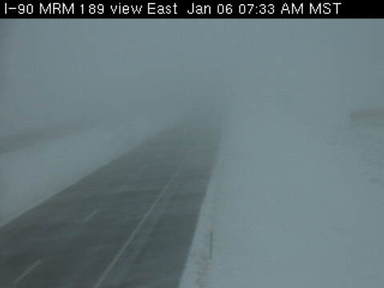
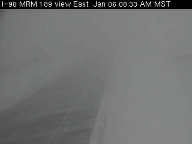
As this system tracked eastward into the Great Lakes region, strong north to northwest winds in the wake of the low gusted as high as 50 mph resulting in significant blowing and drifting snow across much of the area. The hardest hit areas were generally along the Missouri River valley, where blizzard conditions were reported for several hours during the afternoon and evening. Visibility in these areas frequently dropped to below one quarter mile, with near whiteout conditions at times. In fact, Interstate 90 between Sioux Falls and Rapid City was closed due to poor travel conditions.
SD DOT webcam images from Wednesday morning near Murdo, SD (1/6/10)
 |
 |
Below is a storm total snowfall graphic from the storm, and a tabular list of snowfall reports received at the NWS in Aberdeen.
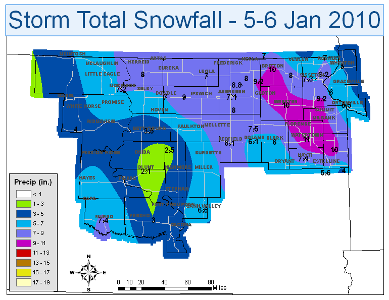
...FINAL STORM TOTAL SNOWFALL REPORTS FROM 5-6 JANUARY 2010...
BELOW IS A SUMMARY OF THE STORM TOTAL SNOWFALL REPORTS FROM WINTER
STORM/BLIZZARD ON 5-6 JANUARY 2010.
-------------------------------------------------------------------
LOCATION SNOW FALL TIME/DATE
(INCHES) OF OBSERVATION LAT LON
MINNESOTA
...BIG STONE COUNTY...
1 N ORTONVILLE 5.5 M 139 PM 01/07 45.32N 96.44W
5 S BEARDSLEY 6.0 E 1100 PM 01/06 45.49N 96.71W
...TRAVERSE COUNTY...
BROWNS VALLEY 7.5 M 1100 PM 01/06 45.59N 96.83W
LOCATION SNOW FALL TIME/DATE
(INCHES) OF OBSERVATION LAT LON
SOUTH DAKOTA
...BROWN COUNTY...
1 E ABERDEEN 7.8 M 139 PM 01/07 45.47N 98.46W
6 NE COLUMBIA 8.0 M 139 PM 01/07 45.68N 98.22W
1 S COLUMBIA 8.8 M 139 PM 01/07 45.60N 98.31W
...BUFFALO COUNTY...
GANN VALLEY 6.5 M 139 PM 01/07 44.03N 98.99W
...CODINGTON COUNTY...
WATERTOWN 11.0 M 139 PM 01/07 44.91N 97.17W
...DAY COUNTY...
WEBSTER 10.0 M 139 PM 01/07 45.34N 97.52W
...DEUEL COUNTY...
CLEAR LAKE 10.0 M 139 PM 01/07 44.77N 96.68W
...EDMUNDS COUNTY...
BOWDLE 7.0 M 600 PM 01/06 45.45N 99.66W
ROSCOE 9.0 M 139 PM 01/07 45.45N 99.33W
...HAMLIN COUNTY...
HAYTI 7.1 M 139 PM 01/07 44.66N 97.20W
...JONES COUNTY...
MURDO 7.4 M 139 PM 01/07 43.89N 100.71W
...MARSHALL COUNTY...
ROY LAKE STATE PARK 6.0 M 139 PM 01/07 45.71N 97.43W
...ROBERTS COUNTY...
4 NNE VICTOR 7.0 M 139 PM 01/07 45.92N 96.80W
3 W SISSETON 7.3 M 139 PM 01/07 45.66N 97.11W
WILMOT 9.2 M 139 PM 01/07 45.41N 96.86W
...SPINK COUNTY...
DOLAND 6.1 M 139 PM 01/07 44.89N 98.10W
TURTON 7.5 M 139 PM 01/07 45.05N 98.10W
REDFIELD 8.1 E 139 PM 01/07 44.87N 98.52W
...WALWORTH COUNTY...
MOBRIDGE 7.2 M 139 PM 01/07 45.54N 100.44W
$$
Mike Fowle - SOO

