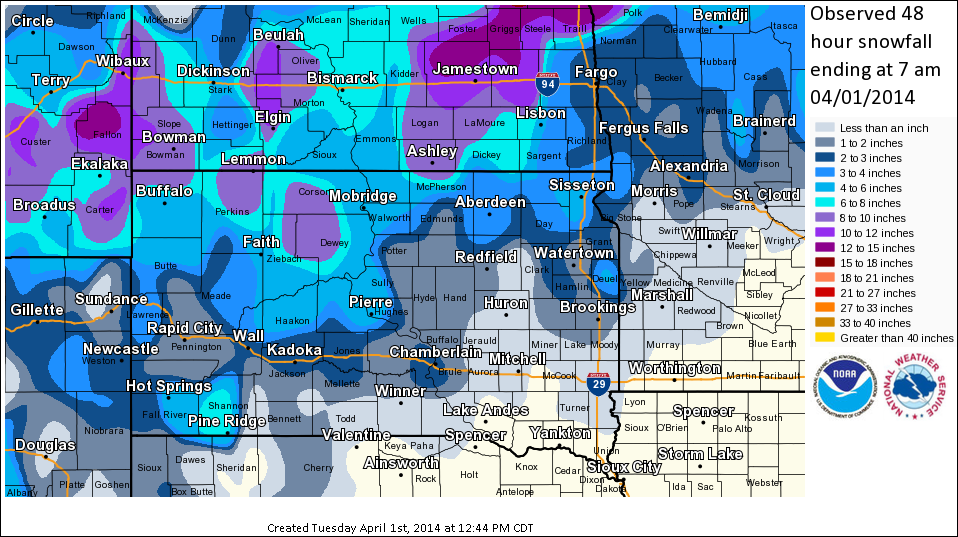
A complex and intense spring storm system tracked across the northern plains on March 31st, 2014. The storm system was about 6-12 hours slower to arrive than originally anticipated - but managed to pack a powerful punch! Snow developed across west-central South Dakota during the morning hours on Monday, with a light wintry mix of freezing rain, sleet, and snow occurring across eastern South Dakota. As winds increased out of the north-northwest, the combination of moderate to heavy snow and wind speeds in excess of 50 mph quickly led to widespread blizzard conditions west of the Missouri River by noon. The snow and wind gradually spread eastward, resulting in the onset of blizzard conditions from early afternoon to early evening across eastern South Dakota and west-central Minnesota. Visibility was reduced below one quarter mile in most areas, with complete white-out conditions at times. Storm total snowfall amounts were significant, ranging from 6 to 10 inches near the North Dakota border, to 1 to 4 inches along and south of Interstate 90.
In addition to the snow, a few thunderstorms developed over far eastern South Dakota and western Minnesota. Several reports of dime to nickel sized hail were reported, along with funnel clouds and even a confirmed tornado touchdown. What was even more amazing - is that this tornado occurred in an area that received blizzard conditions just a few hours later! This just exemplifies the intense and energetic nature of this storm system.
Below is a tabular and graphic display of the storm total snowfall reported across the area, along with a listing of highest wind speeds.
Storm Total Snowfall thru 7am on 1 April 2014:
...LATEST STORM TOTAL SNOWFALL REPORTS...
LOCATION AMOUNT TIME/DATE LAT/LON
SISSETON AIRPORT 10.0 IN 0656 AM 04/01 45.67N/97.00W
PIERRE CAPITOL 6.0 IN 0811 AM 04/01 44.36N/100.33W
HAYES 6E 5.0 IN 0800 AM 04/01 44.37N/100.89W
4 W SISSETON 4.6 IN 0700 AM 04/01 45.66N/97.12W
SISSETON 3W 4.6 IN 0700 AM 04/01 45.66N/97.12W
EUREKA-15MI.SE 4.5 IN 0900 AM 04/01 45.57N/99.48W
ROSCOE 4.0 IN 0700 AM 04/01 45.45N/99.35W
WHEATON 3.5 IN 0700 AM 04/01 45.80N/96.48W
1 NE ABERDEEN 3.4 IN 0700 AM 04/01 45.48N/98.47W
ABERDEEN 3E 3.3 IN 0700 AM 04/01 45.46N/98.41W
ABERDEEN REGIONAL AIRPORT 3.3 IN 0653 AM 04/01 45.46N/98.41W
WESTPORT 2 NW 3.0 IN 0700 AM 04/01 45.68N/98.53W
SISSETON-32MI.SW 3.0 IN 1200 AM 04/01 45.33N/97.53W
4 SE HAZEL 3.0 IN 0830 AM 04/01 44.70N/97.33W
1 SSW ABERDEEN 3.0 IN 0700 AM 04/01 45.45N/98.49W
2 SSE CLAREMONT 2.8 IN 0700 AM 04/01 45.64N/98.00W
PIERRE-38MI.SW 2.5 IN 0900 AM 04/01 43.88N/100.72W
2 ENE SANDY SHORE STATE PARK 2.4 IN 0700 AM 04/01 44.91N/97.21W
DAM 2.0 IN 0800 AM 04/01 45.87N/96.57W
MILBANK 2.0 IN 0730 AM 04/01 45.22N/96.63W
9 NW GANN VALLEY 2.0 IN 0800 AM 04/01 44.08N/99.15W
7 SW CEDAR CREEK REC AREA 2.0 IN 0700 AM 04/01 44.07N/100.01W
2 SSW WESTOVER 2.0 IN 0900 AM 04/01 43.72N/100.68W
8 WNW GANN VALLEY 1.8 IN 0700 AM 04/01 44.08N/99.13W
8 W AMES 1.7 IN 0700 AM 04/01 44.30N/99.26W
HAYTI 1W 1.6 IN 0800 AM 04/01 44.66N/97.23W
CASTLEWOOD NO. 2 1.5 IN 0800 AM 04/01 44.73N/97.03W
2 NW SPOTTSWOOD 1.5 IN 0800 AM 04/01 44.68N/98.53W
12 N HIGHMORE 1.5 IN 0700 AM 04/01 44.70N/99.41W
PRESHO 1.5 IN 0700 AM 04/01 43.90N/100.06W
ROSCOE 1.1 IN 0700 AM 04/01 45.45N/99.34W
TURTON 1.0 IN 0700 AM 04/01 45.05N/98.10W
18 N HOLABIRD 1.0 IN 0700 AM 04/01 44.78N/99.57W
LEOLA (SDSU) 0.9 IN 0700 AM 04/01 45.72N/98.93W
WATERTOWN 2 S 0.7 IN 0800 AM 04/01 44.87N/97.12W
3 E WATERTOWN 0.5 IN 0700 AM 04/01 44.91N/97.11W
GANN VALLEY 0.5 IN 0800 AM 04/01 44.03N/98.99W
DOLAND 0.4 IN 0800 AM 04/01 44.87N/98.10W
OBSERVATIONS ARE COLLECTED FROM A VARIETY OF SOURCES WITH VARYING
EQUIPMENT AND EXPOSURE. NOT ALL DATA LISTED ARE CONSIDERED OFFICIAL.
Peak Wind Gusts from 31 March 2014:
LOCATION                       SPEED     TIME/DATE       LAT/LON
EUREKA 13 NE (SAND LAKE RAWS)  62 MPH    0515 PM 03/31   45.88N/99.41W
6 W HENRY                      62 MPH    0730 PM 03/31   44.88N/97.58W
CRAVEN CORNER                  60 MPH    1220 PM 03/31   45.45N/98.93W
SISSETON AIRPORT               59 MPH    1157 PM 03/31   45.67N/97.00W
1 S GETTYSBURG                 58 MPH    0655 PM 03/31   44.99N/99.95W
1 WNW MELLETTE                 58 MPH    0720 PM 03/31   45.16N/98.51W
4 S RICHMOND LAKE REC AREA     58 MPH    0504 PM 03/31   45.47N/98.62W
HILLHEAD 3 WSW                 57 MPH    0959 PM 03/31   45.80N/97.45W
1 WSW SUMMIT                   57 MPH    0740 PM 03/31   45.30N/97.06W
12 N VIVIAN                    57 MPH    0459 PM 03/31   44.12N/100.30W
HAYTI                          56 MPH    0924 PM 03/31   44.66N/97.20W
3 SE RELIANCE                  56 MPH    0350 PM 03/31   43.85N/99.56W
FAULKTON                       55 MPH    0555 PM 03/31   45.03N/99.11W
WATERTOWN MUNICIPAL AIRPORT    55 MPH    0718 PM 03/31   44.91N/97.15W
3 SSW WHITLOCKS BAY REC AREA   54 MPH    0330 PM 03/31   45.01N/100.29W
ABERDEEN REGIONAL AIRPORT      53 MPH    0214 PM 03/31   45.46N/98.41W
6 SSW PEEVER                   53 MPH    0540 PM 03/31   45.46N/96.99W
2W OACOMA                      53 MPH    1230 PM 03/31   43.80N/99.42W
5E ORIENT                      53 MPH    0540 PM 03/31   44.90N/98.98W
4 W TRAIL CITY                 53 MPH    1210 PM 03/31   45.47N/100.81W
11 S BULLHEAD                  52 MPH    0306 PM 03/31   45.61N/101.06W
7 N FREDERICK                  52 MPH    0540 PM 03/31   45.93N/98.51W
1 SW BOWDLE                    51 MPH    0531 PM 03/31   45.44N/99.68W
1 E HARROLD                    51 MPH    0550 PM 03/31   44.52N/99.72W
3 S WEBSTER                    51 MPH    0855 PM 03/31   45.29N/97.51W
5 E DANFORTH                   51 MPH    0441 PM 03/31   44.24N/98.77W
ANDOVER                        50 MPH    0520 PM 03/31   45.41N/97.91W
2 N HERREID                    50 MPH    0230 PM 03/31   45.87N/100.07W
MOBRIDGE MUNI AP               49 MPH    0202 PM 03/31   45.55N/100.41W
7 ENE DEMPSTER                 48 MPH    1230 AM 04/01   44.66N/98.82W
LEOLA                          48 MPH    0137 PM 03/31   45.72N/98.93W
2 SSE MAHTO                    48 MPH    0925 AM 03/31   45.74N/100.66W
13 NNW SANSARC                 48 MPH    1040 AM 03/31   44.67N/101.14W
1 WNW SAINT LAWRENCE           47 MPH    0855 PM 03/31   44.53N/98.96W
PIERRE MUNICIPAL AIRPORT       47 MPH    1220 PM 03/31   44.38N/100.29W
4 SSE CANNING                  46 MPH    0430 PM 03/31   44.35N/100.00W
4 SW WALLACE                   46 MPH    0745 PM 03/31   45.04N/97.55W
7 S CLAREMONT                  45 MPH    0630 PM 03/31   45.57N/98.03W
1 NW HIGHMORE                  45 MPH    0518 PM 03/31   44.53N/99.45W
MCINTOSH                       45 MPH    0724 AM 03/31   45.92N/101.35W


OBSERVATIONS ARE COLLECTED FROM A VARIETY OF SOURCES WITH VARYING
EQUIPMENT AND EXPOSURE. NOT ALL DATA LISTED ARE CONSIDERED OFFICIAL.

