Are 200 inches of snow possible in north central and northeastern South Dakota this winter? A rumor spreading throughout the region this autumn is that the area could experience up to 200 inches of snowfall this upcoming winter. The official National Weather Service Forecast from the Climate Prediction Center in Camp Springs, Maryland is for greater than average chances that temperatures during meteorological winter, defined as December, January, and February (DJF), will be below average. There is also a higher than average chance we will experience above average snowfall amounts (Figures 1 and 2 below).
Over the past 4 decades, 9 moderate to strong La Nina’s have been recorded in the Equatorial Pacific Ocean. La Niña is characterized by unusually cold ocean temperatures in the eastern equatorial Pacific, as compared to El Niño, which is characterized by unusually warm ocean temperatures in the eastern Equatorial Pacific. The majority of La Niña episodes have contributed to below average temperatures at many sites in north-central and northeastern South Dakota during meteorological winter, which is defined as December, January, and February (DJF).
Where did the forecast of 200” of snow come from? We’re not sure. There is much less of an obvious relationship between La Niña and winter snowfall amounts over central and eastern South Dakota. There is, however, more of an apparent pattern that seems to occur with back to back La Niña episodes dating back to the winter of 1970-71. A recent local study (see data below) suggests higher than average snowfall typically occurs in the latter La Niña winter. In other words, chances of above average snowfall are higher in the coming winter season as we enter the second of back to back La Niña winters. As is typical, however, with snowfall forecasting in the northern plains, the devil remains in the details. Small differences (e.g., 100 miles) in the track of a strong surface low pressure make very significant differences in snow accumulation at a particular point on the earth’s surface. Predicting 200 inches of snowfall for any portion of the region is quite a stretch. The highest recorded snowfall amount over the past 118 years in Aberdeen and Sisseton, two of the snowier locations in the county warning area, are 110” and 84” respectively. 200” of snow in one fall through spring season would be unprecedented to say the least.
In summary, we’re quite confident here at the National Weather Service Forecast Office in Aberdeen that north-central and northeast SD will experience below average temperatures during the heart of upcoming winter months. As La Niña strengthens later this fall, a persistent northwest flow in the upper levels of the atmosphere is expected to develop over the Pacific Northwest. This pattern typically brings fast moving clipper systems that bring a quick shot of snow and frequent continental polar airmasses to the region but not the slow moving organized surface lows that dump tremendous amounts of snow on the region. Thus, the uncertainty in regard to the snowfall forecast is higher. Last winter reminded us how important non-splitting large or long-wave troughs developing off of the central and southern California coast and slowly moving east-northeastward through the Central Rockies and Central Plains are to the formation of widespread heavy snow and strong to high winds. These systems have the greatest potential to produce very strong slow moving low pressure systems (aloft and at the surface) that are efficient snow producers which are accompanied by high winds for long periods of time, similar to the New Year’s Blizzard of 2011 and the President’s Day Blizzard in February, 2011.
For more details on the winter outlook for the remainder of the United States, click HERE.
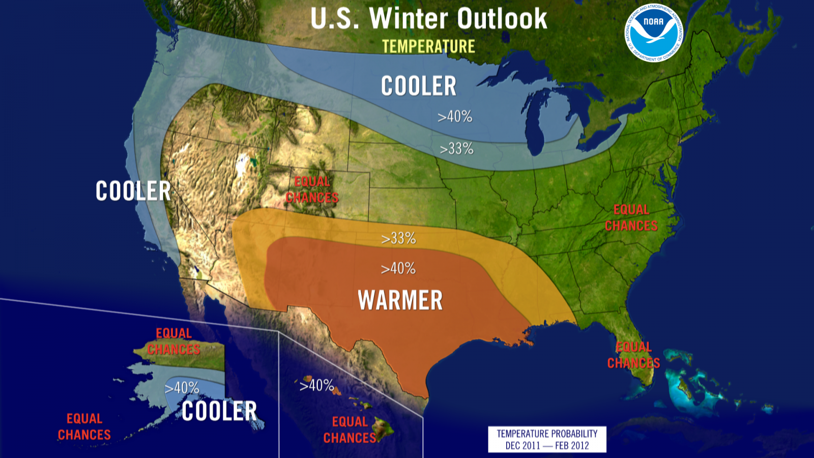
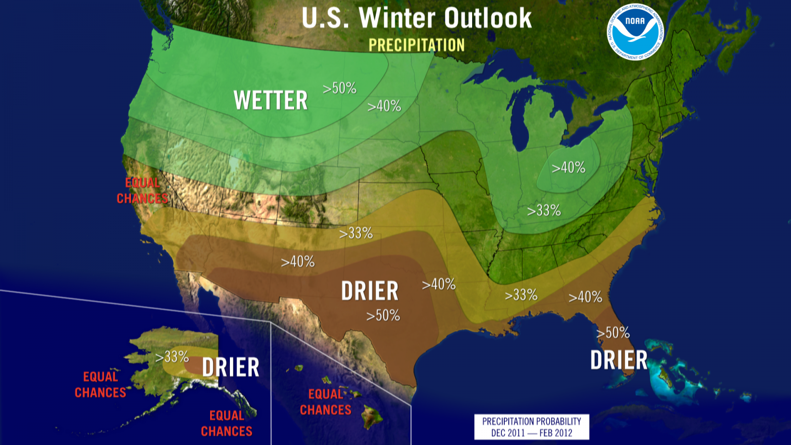
Figure 2. Climate Prediction Center’s Precipitation Probability forecast for meteorological winter 2011-2012. This forecast is not an absolute one. The green represents a higher probability for winter (DJF) precipitation (typically snow in our case) in the Pacific Northwest, northern plains, Great Lakes region, and Ohio and Tennessee Valleys to be above average levels.
Recent local study (Aberdeen, National Weather Service Forecast Office Fall 2011) tables below: indicating a trend for the second of back to back La Niña winters to bring more snow to the region than the first. There is, however, no recent winter season where the initial La Niña winter had nearly double the average annual snowfall for the year (as was observed in the 2010-2011 winter). Typically, the initial La Niña/cold episode had near average seasonal snowfall.
Aberdeen, SD (ABR) - Highest seasonal snowfall on record since 1893: 110” 1936-1937
Average snowfall: 38.6”
|
La Niña Year
|
Snowfall
|
% of snowfall compared to previous La Nina winter
|
|
70’-71’ (moderate-strong)
|
40”
|
|
|
71’-72’ (moderate)
|
44”
|
+10%
|
|
73’-74’ (strong)
|
27”
|
|
|
74’-75’ (moderate)
|
54”
|
+100%
|
|
99’-00’ (strong)
|
19”
|
|
|
00’-01’ (moderate)
|
53”
|
+179%
|
|
07’-08’ (strong)
|
39”
|
|
|
08’-09’ (moderate)
|
56”
|
+44%
|
|
10’-11 (moderate-strong)
|
79”
|
|
|
11’-12’ (forecast of moderate)
|
??
|
??
|
|
La Niña Year (strength)
|
Snowfall
|
% of snowfall compared to previous La Nina winter
|
|
70’-71’ (moderate-strong)
|
28”
|
|
|
71’-72’ (moderate)
|
23”
|
-18%
|
|
73’-74’ (strong)
|
10”
|
|
|
74’-75’ (moderate)
|
53”
|
+430%
|
|
99’-00’ (strong)
|
19”
|
|
|
00’-01’ (moderate)
|
53”
|
+179%
|
|
07’-08’ (strong)
|
24”
|
|
|
08’-09’ (moderate)
|
21”
|
-13%
|
|
10’-11 (moderate-strong)
|
65”
|
|
|
11’-12’ (forecast of moderate)
|
??
|
??
|
|
La Niña Year
|
Snowfall
|
% of snowfall compared to previous La Nina winter
|
|
70’-71’ (moderate-strong)
|
39”
|
|
|
71’-72’ (moderate)
|
56”
|
+44%
|
|
73’-74’ (strong)
|
16”
|
|
|
74’-75’ (moderate)
|
47”
|
+194%
|
|
99’-00’ (strong)
|
20”
|
|
|
00’-01’ (moderate)
|
33”
|
+65%
|
|
07’-08’ (strong)
|
22”
|
|
|
08’-09’ (moderate)
|
56”
|
+155%
|
|
10’-11 (moderate-strong)
|
83”
|
|
|
11’-12’ (forecast of moderate)
|
??
|
??
|
|
La Niña Year
|
Snowfall
|
% of snowfall compared to previous La Nina winter
|
|
70’-71’ (moderate-strong)
|
29”
|
|
|
71’-72’ (moderate)
|
41”
|
+41%
|
|
73’-74’ (strong)
|
31”
|
|
|
74’-75’ (moderate)
|
49”
|
+58%
|
|
99’-00’ (strong)
|
28”
|
|
|
00’-01’ (moderate)
|
67”
|
+139%
|
|
07’-08’ (strong)
|
47”
|
|
|
08’-09’ (moderate)
|
61”
|
+30%
|
|
10’-11 (moderate-strong)
|
84”
|
|
|
11’-12’ (forecast of moderate)
|
??
|
??
|
Kennebec, SD – Highest seasonal snowfall on record since 1893: 73” 2000-2001
Average Snowfall: 32.6”
|
La Niña Year |
Snowfall |
% of snowfall compared to previous La Nina winter |
|
70’-71’ (moderate-strong) |
30” |
|
|
71’-72’ (moderate) |
23” |
-23% |
|
73’-74’ (strong) |
7.5” |
|
|
74’-75’ (moderate) |
39” |
+420% |
|
99’-00’ (strong) |
8” |
|
|
00’-01’ (moderate) |
73” |
+813% |
|
07’-08’ (strong) |
23” |
|
|
08’-09’ (moderate) |
40” |
+74% |
|
10’-11 (moderate-strong) |
67” |
|
|
11’-12’ (forecast of moderate) |
?? |
?? |

