A prolonged atmospheric river will continue to impact the Pacific Northwest into the Northern Rockies with heavy rainfall, areas of urban and river flooding, landslides, heavy mountain snow, and gusty winds into Thursday. A strong clipper system will bring the threat of heavy snow and high winds across the Upper Midwest/Great Lakes as well as portions of the interior Northeast and Appalachians. Read More >
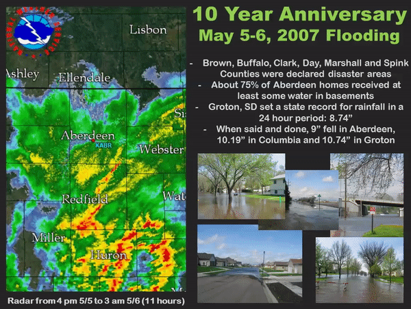
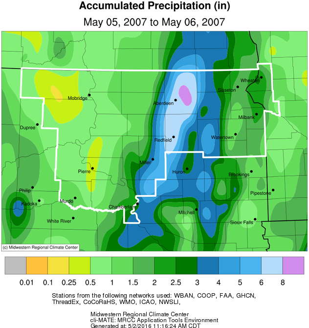
A large upper low-pressure area over the southwestern United States spun off a strong upper-level trough into the northern plains. This trough lifting over the region along with north to south frontal boundary, powerful low-level winds, and abundant gulf moisture resulted in training thunderstorms across parts of central and northeast South Dakota. The training thunderstorms produced torrential rains from 3 to over 10 inches resulting in widespread flash flooding across Brown, Buffalo, Hand, Spink, Clark, Day, Marshall, and Roberts Counties. The counties of Brown, Buffalo, Clark, Day, Marshall, and Spink were declared disaster areas by President Bush. The Governor also declared a state of emergency for the flooded counties with Senator John Thune and Representative Stephanie Herseth surveying the flood damage. Eight damage assessment teams from local, state, and FEMA came to Brown and other counties.
Dozens of cities were affected by the flooding with several hundred homes, businesses, and countless roads affected and damaged or destroyed by the flooding. Aberdeen received the most extensive damage, especially the north side of Aberdeen. Seventy-five percent of the homes in Aberdeen received some water in their basements. Basement water levels ranged from a few inches to very deep water all the way up to the first floor of homes. Many homes had the basement walls collapse. The overwhelming load on the drainage systems caused sewage to back up into many homes across the region. Also, many vehicles stalled on the roads with many others damaged by the flooding. Power outages also occurred across the area. Many families were displaced from their homes with many living in emergency shelters. Countless homes were condemned across the region with many considered unlivable. Thousands of acres of crops were also flooded and damaged with many seeds, and large quantities of fertilizer washed away.
Rainfall amounts from this historic event included 3.65 inches in Miller, 3.82 inches in Britton, 4 inches in Eden, 4.47 inches in Andover, 4.90 inches in Webster, 5.68 inches west of Britton, 5.7 inches in Garden City, and 5.82 inches in Conde. Locations with 6 or more inches of rain included, 6 inches in Langford, 6.33 inches in Gann Valley, 6.72 inches in Clark, 7.41 inches in Ashton, 7.49 inches in Stratford, 7.55 inches near Mellette, 7.97 inches in Aberdeen, 8.02 inches in Redfield, 8.73 inches in Columbia, and 8.74 inches in Groton. The 8.74 inches of rainfall in Groton set a new 24-hour state rainfall record. Adding in the rainfall for the previous day, Aberdeen received a total of 9.00 inches; Columbia received a total of 10.19 inches; Groton received an astonishing two-day total rainfall of 10.74 inches.