National Weather Service United States Department of Commerce
Click a location below for detailed forecast.

Last Map Update: Sun, Apr 20, 2025 at 4:00:09 pm MDT

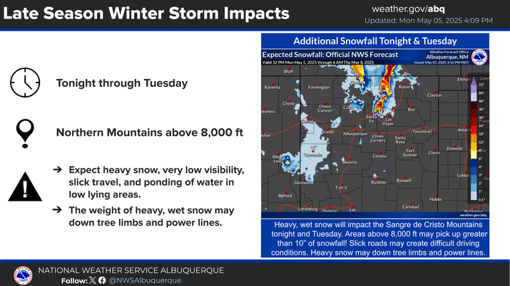
Much colder temperatures tonight, 10 to 15 degrees below seasonal averages. Many areas that are past the average last freeze date will see temperatures drop below freezing early morning tomorrow. Sensitive vegetation may be damaged due to these cold temperatures.
A warming and drying trend is forecast across much of the area this week. Gulf moisture will bring chances for thunderstorms to far eastern NM near the TX border beginning Tuesday. Chances for storms will increase Friday and into the weekend across much of eastern NM.


Text Product Selector (Selected product opens in current window)


Submit Storm Report Icon

Submit Storm Report

Key Impacts Icon

Key Impacts

Observations Icon

Local Observations

Webcams Icon

Office Webcams

Satellite Icon

Satellite Imagery

Are You Prepared Icon

Are You Prepared?

Weekly Weather Briefing Icon

Weekly Weather Briefing

Area Forecast Discussion Icon

Area Forecast Discussion

Fire Weather Icon

Fire Weather

Aviation Weather Icon

Aviation Weather

Snow Probabilities Icon

Snow Probabilities

SKYWARN Icon

SKYWARN Spotters

On This Date in Weather History Icon

On This Date

Climate Graphs Icon

Climate Graphs

Drought Monitor Icon

Drought Monitor

Severe Weather Info and Climatology Icon

Severe Weather Climatology

Monsoon Awareness Icon

Monsoon Awareness

Winter Climatology Icon

Winter Climatology