Scattered severe thunderstorms are possible across portions of the northern High Plains Wednesday afternoon and evening. Severe wind gusts are the primary hazard. Gusty winds and low relative humidity will contribute to critical fire weather conditions across parts of the northern Great Plains and Great Basin Wednesday. Read More >
Introduction |
Typical Patterns |
Hazard Awareness |
Statistics |
Albuquerque Maps |
Resources |
Typical Patterns
|
| Dry, westerly winds begin relaxing over the Desert Southwest as broad areas of high pressure develop over the region. This begins a period of excessive heat across the area followed by a slow moistening of the atmosphere as moisture intrusions make their way into the area from many directions. Once the moisture is in place, thunderstorms will develop daily unless dry westerlies scour out the moisture, or significant subsidence beneath a high pressure ridge dries out the atmosphere to the point where storms cannot develop. There are various upper level patterns that lead to productive wet periods of the North American Monsoon. The following four patterns are the most common across the southwest United States. |
|
| Pattern A: | |
|
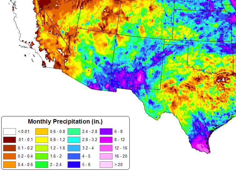
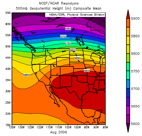
Upper level high pressure centered over the southern Great Plains allows deep-layer south to southeast flow to develop over the desert southwest on the western periphery of the high. This pattern opens the door to moisture pooling over the Gulf of America, northern Mexico, and the Gulf of California. Monsoon “bursts” are common in this pattern, resulting in significant amounts of precipitation for Arizona and New Mexico. Remnant tropical systems from the eastern Pacific can be especially productive for rainfall over the region in this pattern. If the high pressure system is persistent and does not migrate, the summer can be especially wet over central and western New Mexico. The example below shows the mean 500mb geopotential height field (left) and the total precipitation for August 2006 (right). The 2006 monsoon season was the wettest on record for Albuquerque and for the state of New Mexico. |
|
 |
|
| Pattern B: | |
|
Upper level high pressure centered over the Four Corners region or southern Colorado allows easterly waves to shift westward across the southern United States into the desert southwest. Easterly waves can also bring significant increases in moisture, particularly if associated with a remnant tropical system or large convective clusters from the Great Plains. These features typically are preceded by subsidence and a down-tick in storm coverage followed by ascent and significant up-ticks in storm coverage. The example below shows the mean 500mb geopotential height field (left) and the total precipitation for July 2008 (right). Remnant moisture from Hurricane Dolly shifted northwest up the Rio Grande Valley during late July 2008 and resulted in significant flash flooding around Ruidoso. |
|
 |
|
| Pattern C: | |
| Upper level high pressure centered west of NM allows low level moisture from the Great Plains to shift southwest into the area as a result of back door frontal boundaries. This can be particularly true when large convective complexes move off the front range of the Rockies. This pattern tends to be quite favorable for the Rio Grande Valley as storms migrate off the Jemez Mountains down the valley. In this pattern, Albuquerque receives precipitation in the 00-12Z period 2.5 times more often than in the 12-00Z period. North to northwest steering flow in this pattern is also highly favorable for the high plains of eastern New Mexico as convection moves off the central mountain chain. Severe thunderstorms are more likely in this pattern for the eastern plains if enough shear is available in the atmosphere. The example below shows the mean 500mb geopotential height field (left) and the total precipitation for September 2009 (right). | |
 |
|
| Pattern D: | |
|
A sprawling area of upper level high pressure centered directly over New Mexico and Arizona suppresses moisture intrusions into New Mexico, leads to warming mid level temperatures, stronger subsidence, and forces the development of showers and storms to rely heavily on the recycling of low level moisture already in place. Very light steering flow in this pattern leads to slow storm motions and increases the risk for flash flooding from highly localized heavy rainfall. The example below shows the mean 500mb geopotential height field (left) and the total precipitation for July 2007 (right). Note the precipitation maximums across New Mexico are Arizona are more spotty and confined to areas in and around the higher terrain. |
|
 |
|
|
For a more detailed summary of monsoon patterns across the southwestern United States refer to the Tuscon National Weather Service Monsoon Feature. |
|
|
|
|