 |
|
What is a Heat Burst? Heat bursts are interesting, relatively rare, atmospheric nighttime events characterized by gusty winds, a rapid increase in surface temperature, and a decrease in surface dewpoint associated with a dissipating thunderstorm. What causes a Heat Burst?
There are two main atmospheric ingredients that are necessary for a heat burst to occur. The first is a dissipating thunderstorm or shower. Second, the midlevel atmospheric environment must be hot and dry, combined with a shallow surface inversion. Thunderstorms develop when moist, unstable air is given a nudge upward. Moisture in the cloud condenses and later falls as precipitation. Once the thunderstorm loses its updraft, the thunderstorm is said to be downdraft dominated. When this occurs with a hot and dry atmospheric midlevel in place, the moisture associated with the downdraft evaporates and initially cools this layer, increasing its rate of descent toward the surface. However, the descending air will stop cooling once all the moisture has evaporated, therefore causing adiabatic (compressional) warming and mixing of the warm (inversion) layer. The heat burst will occur once the warm and dry air descends to the surface. When and where do they typically occur? Heat bursts generally occur in the late spring and summer seasons. Spring and summertime thunderstorm activity is generally associated with daytime heating, and these said thunderstorms begin to dissipate during the evening hours because they lose their main source of energy. Accordingly, you can usually expect heat bursts to occur in the evening or overnight hours. In New Mexico, heat bursts are most common across the eastern plains. Thunderstorms tend to roll off the higher terrain during the afternoon hours and across the plains during the evening and overnight periods. Generally, a surface inversion will already be in place once thunderstorms begin to dissipate. It is possible for heat bursts to occur west of the central mountain chain if the appropriate conditions are in place, however, a sparse surface observations make it difficult to quantify such events. What are the effects of a Heat Burst? Heat bursts cause a rapid increase in surface temperature, a substantial decrease in surface dewpoint, and on some occasions damaging winds. Recorded temperatures have been known to exceed 100 degrees. This was the case in Wichita, Kansas shortly after midnight on June 9, 2011. The temperature rose from 85 degrees at 1222 am to 102 degrees at 1242 am. Wind speeds have also been known to exceed 70 or 80 mph, as was the case near Clovis, New Mexico below. Winds associated with heat bursts have the potential to rip roofs off buildings, damage trees, or just relocate lawn furniture. |
|
Examples of Heat Bursts in New Mexico |
|
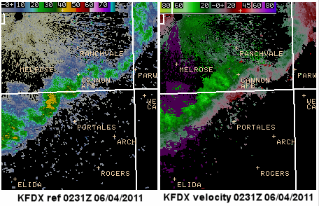
On June 3, 2011, the Cannon Air Force Base (KCVS) recorded a wind gust of 90 mph (78 knots) at 0230Z (8:30 pm MDT). No severe thunderstorms were in the area, only lingering showers from earlier thunderstorm activity. The 90 mph wind gust was caused by a heat burst. At 755 pm, the temperature at KCVS was 71°F and 35 minutes later it jumped to 77°F, which correlates to the onset of the strong winds. KCVS also recorded a drop in dewpoint temperature from 50°F to 43°F during the same time frame. |
|
The 90 mph wind gust was recorded at 0230z, just 1 minute prior to the reflectivity (left) and velocity (right) images from the Cannon AFB radar (KFDX) below. The thick white lines in the images are county borders., and velocities are in knots. The reflectivity image clearly shows light showery precipitation in a serpentine (thin, snake-like) structure (though not shown, the weak reflectivities snaked well into Texas). This type of reflectivity structure is common during heat bursts. However, in the velocity image, there is no indication that there were winds anywhere near 90 mph. This shows that the impact from heat bursts can be very localized, and hard to warn for. |
|
|
| Around 20 minutes later, the KFDX velocity image depicts stronger winds, but generally around the 50 knot range. The velocity images also clearly show a divergent pattern at both 0231Z and 0252Z. |
|
|
|
Below is a graph of the observations at Cannon Air Force Base on June 3, 2011, illustrating the temperature increase and associated dew point decrease (described above) at the time of the heat burst (purple box). |
|
|
|
Another strong heat burst occurred almost 6 hours later near Clayton. This time, however, the temperature rose a whopping 14 degrees in the middle of the night. Between 1255 and 155 am, the temperature jumped from 63 to 77 degrees, while the dewpoint dropped from 46 to 36 degrees. The wind gust at the Clayton ASOS peaked at 56 knots (64 mph). This rather unique event was described in a separate feature, available here. |
|
Around 951 pm MDT (0351Z) on June 19, 2011, a possible heat burst occurred west of the central mountains. The Albuquerque radar (KABX) reflectivity images (loop below) show a prominent snake-like structure (or radar signature) to the showers west of Cuba. Unfortunately, the lack of surface observations in this area of New Mexico cannot prove or deny that a heat burst occurred. However, at the Mesa Chivato RAWS site, approximately 15 miles southeast of the the radar signature, the temperature increased 4 degrees, from 63 to 67, between 851 and 951 pm, though the dewpoint only decreased one degree over this time frame. |
|
|