|
Characteristics of High Wind Events across Northern and Central New Mexico |
|
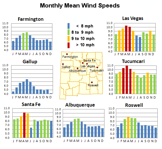
Anyone who is familiar with the climate in New Mexico knows the windiest time of the year is during the Spring months of April and May, with March and June often times not far behind. The graphs below depict mean monthly wind speeds at seven locations across the state - the Spring wind maximum is evident at all sites. High wind events are relatively common across New Mexico, and these strong winds can have a significant impact to lives and property. Strong winds can damage buildings and uproot trees, but can also produce areas of blowing dust that can reduce visibilities making road travel hazardous. NWS Albuquerque issues high wind warnings when winds are expected to have sustained speeds of 40 mph or greater and/or instantaneous gusts of 58 mph or higher. A study was recently completed to determine the frequency of high wind events across New Mexico, and to evaluate the synoptic regime associated with these events. This study showed that high wind events are also most common in the Spring. High wind events often have a westerly component. During the Spring months two factors work in tandem to create strong winds. By March or April, the polar jet stream has started migrating northward but can still often influence the southwest U.S., such that wind speeds increase dramatically with height. Meanwhile, the sun angle is getting higher in the sky and creating greater heating near the surface of the earth. The heated surface air rises to a greater depth of the atmosphere during these spring months, often to a height between 7,500 and 10,000 feet above the surface. The rising air mixes with stronger winds aloft, resulting in stronger and turbulent winds mixing down to the surface. Strong surface pressure gradients can enhance surface winds. High wind events across New Mexico can also occur with strong surface fronts, especially those that race through the eastern plains. Archived wind data can be difficult to obtain. This study was completed using data from eight airport sites across northern and central New Mexico - the seven sites listed in the figure below, and also Clayton in the northeast corner of the state. Some sites had more available data than others, resulting in more robust statistics. It is also important to note that there are locations in New Mexico that experience stronger winds, but have no record of observations available. The complete study is available in pdf format from this link.
|
 |